File:Pommersfelden BW 2011-07-27 17-05-16.jpg
Jump to navigation
Jump to search

Size of this preview: 800 × 267 pixels. Other resolutions: 320 × 107 pixels | 640 × 214 pixels | 1,024 × 342 pixels | 1,280 × 427 pixels | 2,560 × 854 pixels | 7,991 × 2,666 pixels.
Original file (7,991 × 2,666 pixels, file size: 11.28 MB, MIME type: image/jpeg)
Captions
Captions
Add a one-line explanation of what this file represents
Summary
Object
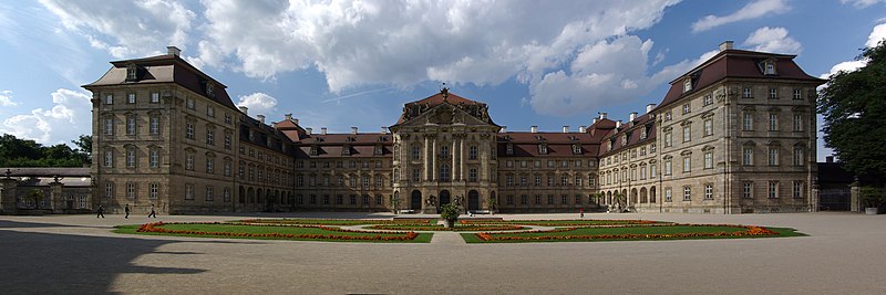
| Schloss Weißenstein
|
|||||||||||||||||||||||||||||||||||||||||||||||||||||||||||||||||
|---|---|---|---|---|---|---|---|---|---|---|---|---|---|---|---|---|---|---|---|---|---|---|---|---|---|---|---|---|---|---|---|---|---|---|---|---|---|---|---|---|---|---|---|---|---|---|---|---|---|---|---|---|---|---|---|---|---|---|---|---|---|---|---|---|---|
| Architect |
|
 | |||||||||||||||||||||||||||||||||||||||||||||||||||||||||||||||
| Title |
Schloss Weißenstein |
||||||||||||||||||||||||||||||||||||||||||||||||||||||||||||||||
| Object type |
château / palace / museum / Ortsteil |
||||||||||||||||||||||||||||||||||||||||||||||||||||||||||||||||
| Description |
Deutsch: Das Schloss Weißenstein liegt bei Pommersfelden bei Bamberg im Landkreis Bamberg in Oberfranken. Erbaut wurde es zwischen 1711 und 1718 unter Lothar Franz von Schönborn, dem Bamberger Fürstbischof und Kurfürst von Mainz. Das Schloss diente dem Kurfürsten Lothar Franz von Schönborn als private Sommerresidenz und ist bis heute im Besitz der Familie Schönborn
English: Schloss Weißenstein in Pommersfelden, Bavaria. |
||||||||||||||||||||||||||||||||||||||||||||||||||||||||||||||||
| Date |
1718 |
||||||||||||||||||||||||||||||||||||||||||||||||||||||||||||||||
| Object location |
|
||||||||||||||||||||||||||||||||||||||||||||||||||||||||||||||||
| Object history |
|
||||||||||||||||||||||||||||||||||||||||||||||||||||||||||||||||
| Authority file | |||||||||||||||||||||||||||||||||||||||||||||||||||||||||||||||||
| Other versions |
|
||||||||||||||||||||||||||||||||||||||||||||||||||||||||||||||||

Photograph
| Date | |
| Source | Own work |
| Author | Berthold Werner |
| Camera location | | View this and other nearby images on: OpenStreetMap |
|---|
Licensing
I, the copyright holder of this work, hereby publish it under the following licenses:

|
Permission is granted to copy, distribute and/or modify this document under the terms of the GNU Free Documentation License, Version 1.2 or any later version published by the Free Software Foundation; with no Invariant Sections, no Front-Cover Texts, and no Back-Cover Texts. A copy of the license is included in the section entitled GNU Free Documentation License. |
This file is licensed under the Creative Commons Attribution-Share Alike 3.0 Unported, 2.5 Generic, 2.0 Generic and 1.0 Generic license.
- You are free:
- to share – to copy, distribute and transmit the work
- to remix – to adapt the work
- Under the following conditions:
- attribution – You must give appropriate credit, provide a link to the license, and indicate if changes were made. You may do so in any reasonable manner, but not in any way that suggests the licensor endorses you or your use.
- share alike – If you remix, transform, or build upon the material, you must distribute your contributions under the same or compatible license as the original.
You may select the license of your choice.
File history
Click on a date/time to view the file as it appeared at that time.
| Date/Time | Thumbnail | Dimensions | User | Comment | |
|---|---|---|---|---|---|
| current | 16:31, 31 July 2011 | 7,991 × 2,666 (11.28 MB) | Berthold Werner (talk | contribs) |
You cannot overwrite this file.
File usage on Commons
The following 2 pages use this file:
File usage on other wikis
The following other wikis use this file:
- Usage on bcl.wikipedia.org
- Usage on cs.wikipedia.org
- Usage on en.wikipedia.org
- Usage on es.wikipedia.org
- Usage on fr.wikipedia.org
- Usage on hr.wikipedia.org
- Usage on it.wikipedia.org
- Usage on lt.wikipedia.org
- Usage on pt.wikipedia.org
- Usage on sl.wikipedia.org
- Usage on th.wikipedia.org
- Usage on uk.wikipedia.org