File:Porta Caribe.svg
Jump to navigation
Jump to search

Size of this PNG preview of this SVG file: 800 × 450 pixels. Other resolutions: 320 × 180 pixels | 640 × 360 pixels | 1,024 × 576 pixels | 1,280 × 720 pixels | 2,560 × 1,440 pixels | 1,058 × 595 pixels.
Original file (SVG file, nominally 1,058 × 595 pixels, file size: 151 KB)
Captions
Captions
Add a one-line explanation of what this file represents
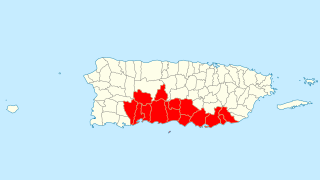
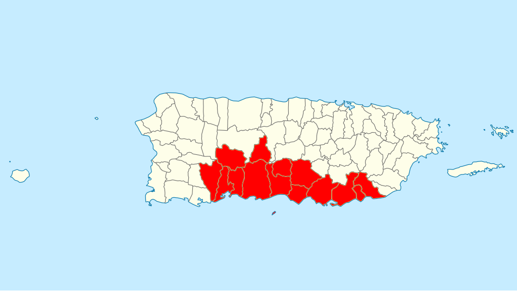
| Description | Quadratische Plattkarte, N-S-Streckung 105 %. Geographische Begrenzung der Karte: * N: 19.0° N * S: 17.5° N * W: 68.0° W * O: 65.2° W Equirectangular projection, N/S stretching 105 %. Geographic limits of the map: * N: 19.0° N * S: 17.5° N * W: 68.0° W * E: 65.2° W |
| Date | (UTC) |
| Source | |
| Author |
|
| This is a retouched picture, which means that it has been digitally altered from its original version. Modifications: Highlighted "Porta Caribe" Tourist Region. The original can be viewed here: USA Puerto Rico location map.svg:
|
I, the copyright holder of this work, hereby publish it under the following license:
This file is licensed under the Creative Commons Attribution-Share Alike 3.0 Unported license.
- You are free:
- to share – to copy, distribute and transmit the work
- to remix – to adapt the work
- Under the following conditions:
- attribution – You must give appropriate credit, provide a link to the license, and indicate if changes were made. You may do so in any reasonable manner, but not in any way that suggests the licensor endorses you or your use.
- share alike – If you remix, transform, or build upon the material, you must distribute your contributions under the same or compatible license as the original.
Original upload log
[edit]
This image is a derivative work of the following images:
- File:USA_Puerto_Rico_location_map.svg licensed with Cc-by-sa-3.0
- 2009-06-19T07:13:05Z NordNordWest 1058x595 (117123 Bytes) {{Information |Description= {{de|Positionskarte von [[:de:Puerto Rico|Puerto Rico]], [[:de:USA|USA]]}} Quadratische Plattkarte, N-S-Streckung 105 %. Geographische Begrenzung der Karte: * N: 19.0° N * S: 17.5° N * W: 68.0°
Uploaded with derivativeFX
File history
Click on a date/time to view the file as it appeared at that time.
| Date/Time | Thumbnail | Dimensions | User | Comment | |
|---|---|---|---|---|---|
| current | 17:35, 31 October 2010 | | 1,058 × 595 (151 KB) | Mercy11 (talk | contribs) | Added highlight for Caja de Muertos Island, which is also part of the Region |
| 17:24, 31 October 2010 |  | 1,058 × 595 (150 KB) | Mercy11 (talk | contribs) | {{Information |Description={{de|Positionskarte von Puerto Rico, USA}} Quadratische Plattkarte, N-S-Streckung 105 %. Geographische Begrenzung der Karte: * N: 19.0° N * S: 17.5° N * W: 68.0° W * O: 65.2° W {{en|Location m |
You cannot overwrite this file.
File usage on Commons
There are no pages that use this file.
File usage on other wikis
The following other wikis use this file:
- Usage on en.wikipedia.org