File:Pyrenees topographic map-en.svg
Jump to navigation
Jump to search

Size of this PNG preview of this SVG file: 800 × 475 pixels. Other resolutions: 320 × 190 pixels | 640 × 380 pixels | 1,024 × 608 pixels | 1,280 × 760 pixels | 2,560 × 1,520 pixels | 3,200 × 1,900 pixels.
Original file (SVG file, nominally 3,200 × 1,900 pixels, file size: 6.3 MB)
Captions
Captions
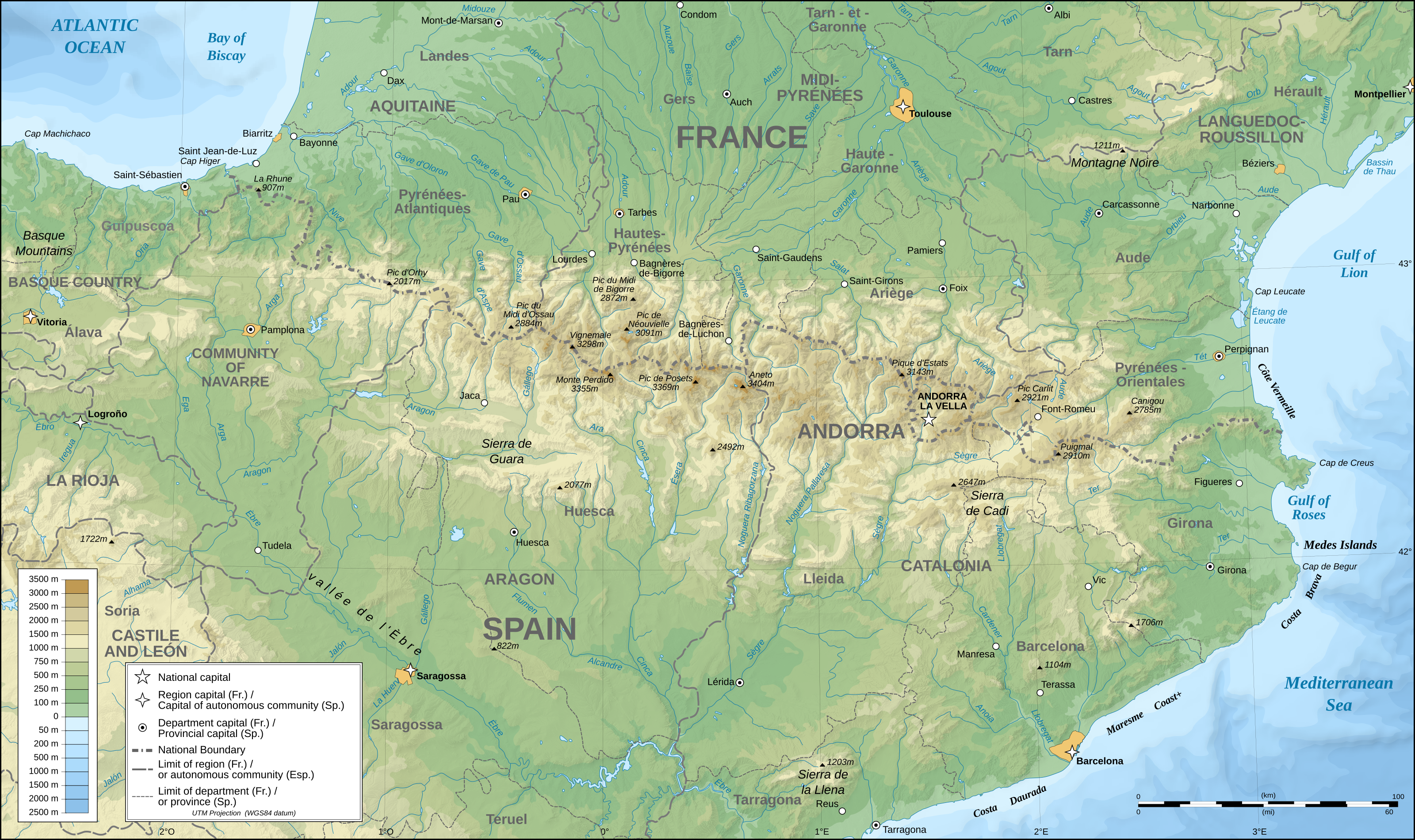
Topographic map of the Pyrenees Mountains
| Description |
English: Topographic map in English of the Pyrenees Mountains. Note: The shaded relief is a raster image embedded in the SVG file. Français : Carte topographique des Pyrénées en english.
UTM projection; WGS84 datum; shaded relief (composite image of N-W, W and N lightning positions);Note : Le relief ombré est une image bitmap embarquée dans le fichier SVG. *The approximate horizontal accuracy of topographic data and shore/lakes limits is 1,125 m (per pixel). This map should not be printed over a 1:1 ratio (27.09 x 16.09cm), which corresponds to a scale of 1:2,010,221. *Approximate scale of the bathymetry: 1:7,708,000 (precision: 1,927 m) |
| Date | (UTC) |
| Source | |
| Author |
|
| This is a retouched picture, which means that it has been digitally altered from its original version. Modifications: translation into English. The original can be viewed here: Pyrenees topographic map-fr.svg:
|
I, the copyright holder of this work, hereby publish it under the following licenses:
This file is licensed under the Creative Commons Attribution-Share Alike 2.5 Generic, 2.0 Generic and 1.0 Generic license.
- You are free:
- to share – to copy, distribute and transmit the work
- to remix – to adapt the work
- Under the following conditions:
- attribution – You must give appropriate credit, provide a link to the license, and indicate if changes were made. You may do so in any reasonable manner, but not in any way that suggests the licensor endorses you or your use.
- share alike – If you remix, transform, or build upon the material, you must distribute your contributions under the same or compatible license as the original.
| This file is licensed under the Creative Commons Attribution-Share Alike 3.0 Unported license. | ||
| ||
| This licensing tag was added to this file as part of the GFDL licensing update. |

|
Permission is granted to copy, distribute and/or modify this document under the terms of the GNU Free Documentation License, Version 1.2 or any later version published by the Free Software Foundation; with no Invariant Sections, no Front-Cover Texts, and no Back-Cover Texts. A copy of the license is included in the section entitled GNU Free Documentation License. |
You may select the license of your choice.
Original upload log
[edit]
This image is a derivative work of the following images:
- File:Pyrenees_topographic_map-fr.svg licensed with Cc-by-sa-2.5,2.0,1.0, Cc-by-sa-3.0-migrated, GFDL
- 2008-09-23T15:49:03Z Sting 3200x1900 (6608359 Bytes) Using ETOPO1 data for bathymetry; new standard colors
- 2007-07-02T00:25:17Z Sting 3200x1900 (6191391 Bytes) + projection info in key ; + major cities areas ; some corrections in the rivers
- 2007-06-25T20:30:25Z Sting 3200x1900 (6166321 Bytes) + key for borders
- 2007-05-31T21:18:03Z Sting 3200x1900 (6163256 Bytes) Some corrections
- 2007-05-30T18:23:51Z Sting 3200x1900 (6163275 Bytes) {{Information |Description=Topographic map in French of the [[:en:Pyrenees|Pyrenees mountains]] |Source=Own work ;Topographic map : [http://www2.jpl.nasa.gov/srtm NASA Shuttle Radar Topography Mission] (SRTM3 v.2) (public dom
File history
Click on a date/time to view the file as it appeared at that time.
| Date/Time | Thumbnail | Dimensions | User | Comment | |
|---|---|---|---|---|---|
| current | 00:25, 28 May 2011 | | 3,200 × 1,900 (6.3 MB) | RedWolf (talk | contribs) | {{Information |Description={{en|Topographic map in English of the Pyrenees mountains.<br/>''Note:'' The shaded relief is a raster image embedded in the SVG file.}} {{fr|Carte topographique des Pyrénées en english.<br/ |
You cannot overwrite this file.
File usage on Commons
The following 12 pages use this file:
- File:Pyrenees map shaded relief-fr.svg
- File:Pyrenees relief map with rivers-fr.svg
- File:Pyrenees topo map-blank.jpg
- File:Pyrenees topographic map-ca.svg
- File:Pyrenees topographic map-de.svg
- File:Pyrenees topographic map-eo.svg
- File:Pyrenees topographic map-es.svg
- File:Pyrenees topographic map-fr.svg
- File:Pyrenees topographic map-mk.svg
- File:Pyrenees topographic map-pl.svg
- File:Pyrenees topographic map-ru.svg
- Template:Other versions/Pyrenees topographic map
File usage on other wikis
The following other wikis use this file:
- Usage on am.wikipedia.org
- Usage on ar.wikipedia.org
- Usage on bg.wikipedia.org
- Usage on bh.wikipedia.org
- Usage on bn.wikipedia.org
- Usage on ca.wikipedia.org
- Usage on ceb.wikipedia.org
- Usage on cs.wikipedia.org
- Usage on da.wikipedia.org
- Usage on en.wikipedia.org
- Pyrenees
- Col du Tourmalet
- Canigou
- Aneto
- Pic du Midi de Bigorre
- Pre-Pyrenees
- Alp 2500
- Masella
- Vignemale
- Monte Perdido
- Pic du Midi d'Ossau
- Montsec Range
- Larrun
- Pica d'Estats
- Formigal Ski Resort
- Candanchú
- Astún
- Panticosa-Los Lagos
- Cerler
- Col d'Aubisque
- Mallos de Riglos
- Collarada
- Pla d'Adet
- Mount Baigura
- Baqueira-Beret
- Balaïtous
- Col d'Ares
- Col d'Aspin
- Vallnord
- Pic Long
- Plateau de Beille
- Corbières Massif
- Hautza
- La Mongie
- Pic del Port Vell
- Pic de Sanfonts
- Port de Pailhères
View more global usage of this file.