File:ROC PRC comparison eng.jpg
ROC_PRC_comparison_eng.jpg (770 × 600 pixels, file size: 239 KB, MIME type: image/jpeg)
Captions
Captions

|
File:ROC vs PRC.svg is a vector version of this file. It should be used in place of this JPG file when not inferior.
File:ROC PRC comparison eng.jpg → File:ROC vs PRC.svg
For more information, see Help:SVG. |
 |

|
This map has been uploaded by Electionworld from en.wikipedia.org to enable the |
Summary
[edit]
| Description |
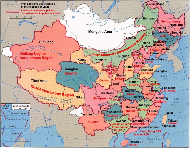
English: Comparison between Republic of China and People's Republic of China administrative divisions.
Adapted into English by Pryaltonian from the Chinese Wikipedia. The original ROC map included more cities, but the adaptation removed non-central municipalities to clean up the image. Therefore, this image contains: Republic of China
People's Republic of China
The image also includes the addition of Chongqing as a municipality and the Gansu-Qinghai border change. Comments, suggestions, adaptations, critiques are all welcome. |
| Date | |
| Source | Own work |
| Author | Electionworld |
Licensing
[edit]

|
Permission is granted to copy, distribute and/or modify this document under the terms of the GNU Free Documentation License, Version 1.2 or any later version published by the Free Software Foundation; with no Invariant Sections, no Front-Cover Texts, and no Back-Cover Texts. A copy of the license is included in the section entitled GNU Free Documentation License. |
| This file is licensed under the Creative Commons Attribution-Share Alike 3.0 Unported license. | ||
| ||
| This licensing tag was added to this file as part of the GFDL licensing update. |
GNU was used on the Chinese page, so same copyright information should apply. -Pryaltonian 04:45, 3 September 2006 (UTC)
File history
Click on a date/time to view the file as it appeared at that time.
| Date/Time | Thumbnail | Dimensions | User | Comment | |
|---|---|---|---|---|---|
| current | 19:48, 18 January 2015 | | 770 × 600 (239 KB) | Wwbread (talk | contribs) | Part of Bhutan and Russia was Rep. China. It has been marked in this map but not painted white. Also marked Nanking and Peking by two bigger stars. |
| 14:03, 16 December 2006 |  | 770 × 600 (316 KB) | Electionworld (talk | contribs) | {{ew|en|Pryaltonian}} == Legend details == * Black dotted lines are political boundaries drawn by the ROC. The formal names of these political entities are in black text. * Red solid lines are political boundaries drawn by the [[P |
You cannot overwrite this file.
File usage on Commons
The following 2 pages use this file:
File usage on other wikis
The following other wikis use this file:
- Usage on en.wikipedia.org
- Talk:Chinese Soviet Republic
- Talk:Sino-Indian War
- Talk:Chinese constellations
- Talk:Black-faced spoonbill
- User:Pryaltonian
- Talk:Yixian Formation
- Talk:Shanxia
- Talk:Stegosaurides
- Talk:Tianchisaurus
- Talk:Heishansaurus
- Talk:Parama China kingdom
- Talk:Pingxing Pass
- Talk:Eleutherococcus senticosus
- Talk:List of Chinese star names
- Template:WikiProject China
- Talk:Chinese paddlefish
- File talk:ROC PRC comparison eng.jpg
- Template talk:WikiProject China
- Talk:Qingdao
- File talk:Zhengzhou location.png
- Talk:Wu (state)
- Wikipedia talk:WikiProject China/Cartography
- Talk:Snakehead (gang)
- Talk:Morina nepalensis
- User talk:Nlu/archive34
- Talk:Qabiao language
- Talk:Nectocaris
- Talk:Daurian starling
- Talk:Reed parrotbill
- Talk:Chinese penduline tit
- Talk:Chinese thrush
- Talk:Zhejiangosaurus
- Talk:Philippen's striped turtle
- Talk:Chinese false-eyed turtle
- Talk:Mutianyu
- Talk:Wuji County
- Talk:Aristolochia thwaitesii
- Talk:Chinese star maps
- Talk:Hamamelis mollis
- Talk:Jiufotang Formation
- Talk:North Linkor Road
- Talk:Beijing–Datong Expressway
- Talk:Ailurarctos
- Talk:Wan Chai Cargo Handling Basin
- Talk:Platostoma palustre
- Talk:China National Highway 324
- Template:WikiProject China/sandbox
- Talk:Paleobiota of the Yixian Formation
- Talk:Tiaojishan Formation
- Talk:Five Lotus Spring
View more global usage of this file.