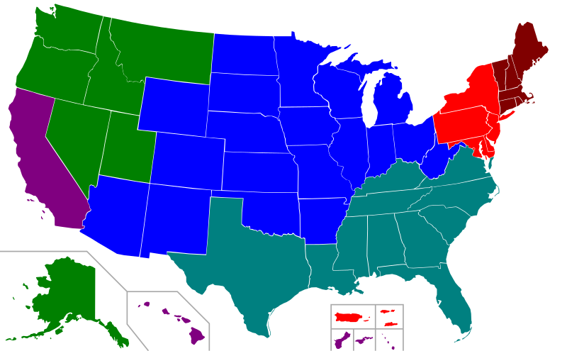
File:Regional accreditation map.svg

Original file (SVG file, nominally 959 × 593 pixels, file size: 37 KB)
Captions
Captions
Summary
[edit]| DescriptionRegional accreditation map.svg |
A map of the regional accreditation agencies. Legend: |
||
| Date | (UTC) | ||
| Source |
This file was derived from: Blank USA, w territories.svg: |
||
| Author | File:Blank USA, w territories.svg: Lokal_Profil | ||
| Other versions |
Derivative works of this file:
All the below are of the states (and DC) only.
|
||
| SVG development InfoField |
|
Licensing
[edit]| This file is licensed under the Creative Commons Attribution-Share Alike 3.0 Unported license. | ||
| ||
| This licensing tag was added to this file as part of the GFDL licensing update.http://creativecommons.org/licenses/by-sa/3.0/CC BY-SA 3.0Creative Commons Attribution-Share Alike 3.0truetrue |

|
Permission is granted to copy, distribute and/or modify this document under the terms of the GNU Free Documentation License, Version 1.2 or any later version published by the Free Software Foundation; with no Invariant Sections, no Front-Cover Texts, and no Back-Cover Texts. A copy of the license is included in the section entitled GNU Free Documentation License.http://www.gnu.org/copyleft/fdl.htmlGFDLGNU Free Documentation Licensetruetrue |
Original upload log
[edit]This image is a derivative work of the following images:
- File:Blank_USA,_w_territories.svg licensed with Cc-by-sa-3.0-migrated, GFDL
- 2009-01-30T01:59:59Z Hoshie 959x593 (98189 Bytes) Reverted to version as of 23:58, 14 January 2009 - rv myself; DC can be seen clearly.
- 2009-01-18T23:34:42Z Hoshie 959x593 (102341 Bytes) Put DC in an inset; fixed Tutuila (American Samoa)
- 2009-01-14T23:58:05Z Lokal Profil 959x593 (98189 Bytes) Code cleanup and removed stroke from Guam and American Samoa
- 2009-01-13T05:19:51Z Hoshie 959x593 (101361 Bytes) re did Guam and added American Samoa
- 2007-12-02T16:08:45Z Lokal Profil 959x593 (88960 Bytes) {{Information |Description=A blank map of the United States including Puerto Rico, Guam, the United States Virgin Islands, and the Northern Mariana Islands. |Source=This version was made by [[:User:Lokal_Profil|Lokal_Profil]]
Uploaded with derivativeFX
File history
Click on a date/time to view the file as it appeared at that time.
| Date/Time | Thumbnail | Dimensions | User | Comment | |
|---|---|---|---|---|---|
| current | 08:19, 12 July 2016 |  | 959 × 593 (37 KB) | Newfraferz87 (talk | contribs) | Slash code |
| 21:19, 27 May 2013 |  | 959 × 593 (113 KB) | Presidentman (talk | contribs) | == {{int:filedesc}} == {{Information |Description=A map of the regional accreditation agencies.<br>'''Legend:'''{{Legend|red|MSA}}{{Legend|#800000|NEASC}}{{Legend|blue|NCA}}{{Legend|green|NAC}}{{Legend|#008080|SACS}}{{Legen... |
You cannot overwrite this file.
File usage on Commons
The following page uses this file:
File usage on other wikis
The following other wikis use this file:
- Usage on he.wikipedia.org
- Usage on sh.wikipedia.org
- Asocijacija koledža i škola saveznih država srednjeg Atlantika
- Asocijacija škola i koledža Nove Engleske
- Asocijacija koledža i škola sjevernih i centralnih saveznih država
- Sjeverozapadna komisija za univerzitete i koledže
- Asocijacija koledža i škola američkog Juga
- Zapadna asocijacija škola i koledža
- Šablon:Regionalna akreditacija univerziteta u SAD-u
Metadata
This file contains additional information such as Exif metadata which may have been added by the digital camera, scanner, or software program used to create or digitize it. If the file has been modified from its original state, some details such as the timestamp may not fully reflect those of the original file. The timestamp is only as accurate as the clock in the camera, and it may be completely wrong.
| Short title | US regional accreditation |
|---|---|
| Width | 959 |
| Height | 593 |