File:Relief map of Canada.png
Jump to navigation
Jump to search
Size of this preview: 706 × 599 pixels. Other resolutions: 283 × 240 pixels | 566 × 480 pixels | 905 × 768 pixels | 1,084 × 920 pixels.
Original file (1,084 × 920 pixels, file size: 1.82 MB, MIME type: image/png)
Captions
Captions
Add a one-line explanation of what this file represents
Summary
[edit]| Description |
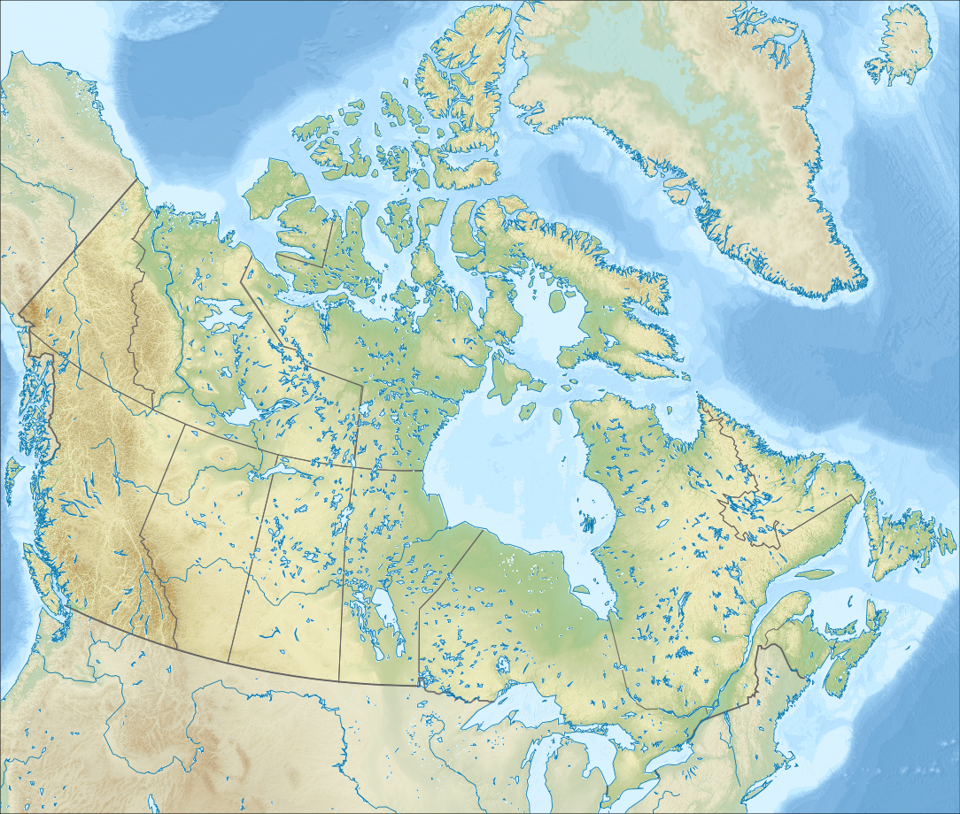
Русский: Физическая карта Канады.
English: Relief map of Canada.
|
| Date | |
| Source |
|
| Author | Nzeemin |
| Other versions |
|

Licensing
[edit]
I, the copyright holder of this work, hereby publish it under the following license:
This file is licensed under the Creative Commons Attribution-Share Alike 3.0 Unported license.
- You are free:
- to share – to copy, distribute and transmit the work
- to remix – to adapt the work
- Under the following conditions:
- attribution – You must give appropriate credit, provide a link to the license, and indicate if changes were made. You may do so in any reasonable manner, but not in any way that suggests the licensor endorses you or your use.
- share alike – If you remix, transform, or build upon the material, you must distribute your contributions under the same or compatible license as the original.
File history
Click on a date/time to view the file as it appeared at that time.
| Date/Time | Thumbnail | Dimensions | User | Comment | |
|---|---|---|---|---|---|
| current | 18:00, 28 September 2012 | | 1,084 × 920 (1.82 MB) | Nzeemin (talk | contribs) | User created page with UploadWizard |
You cannot overwrite this file.
File usage on Commons
There are no pages that use this file.
File usage on other wikis
The following other wikis use this file:
- Usage on ar.wikipedia.org
- Usage on arz.wikipedia.org
- Usage on ast.wikipedia.org
- Usage on az.wikipedia.org
- Qayalı dağlar
- Labrador dənizi
- Bofort dənizi
- Baffin Torpağı
- Annapolis QÇES
- Şablon:Yer xəritəsi Kanada
- Fandi körfəzi
- Fandi Milli Parkı
- Nahanni Milli Parkı
- Vud-Baffalo Milli Parkı
- Qros-Morn Milli Parkı
- Miquaşa Milli Parkı
- Buthia yarımadası
- Dikson-Entrans boğazı
- Hekate boğazı
- Şahzadə Şarlotta boğazı
- Hove boğazı
- Corciya boğazı
- Xuan de Fuka boğazı
- Smit boğazı
- Baffin dənizi
- Devis boğazı
- Robeson boğazı
- Kennedi boğazı
- Parri boğazı
- Danimarka boğazı
- Franklin boğazı
- Şahzadə Qustav-Adolf dənizi
- Nares boğazı
- Fari və Hekla boğazı
- Şahzadə Regent boğazı
- Hudzon boğazı
- Mak-Klintok boğazı
- Dis boğazı
- Dolfin və Yunion boğazı
- Cons boğazı
- Kabot boğazı
- Kanso boğazı
- Nortamberlend boğazı
- Simpson boğazı
- Vaykaunt-Melvill boğazı
- Uels Şahzadəsi (boğaz)
- Barrou boğazı
View more global usage of this file.