File:RomanItaly.svg
Jump to navigation
Jump to search

Size of this PNG preview of this SVG file: 487 × 600 pixels. Other resolutions: 195 × 240 pixels | 390 × 480 pixels | 623 × 768 pixels | 831 × 1,024 pixels | 1,662 × 2,048 pixels | 1,760 × 2,168 pixels.
Original file (SVG file, nominally 1,760 × 2,168 pixels, file size: 2.28 MB)
Captions
Captions
Add a one-line explanation of what this file represents
Summary
[edit]
| Description |
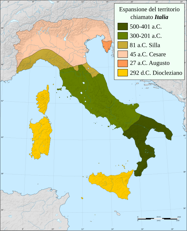
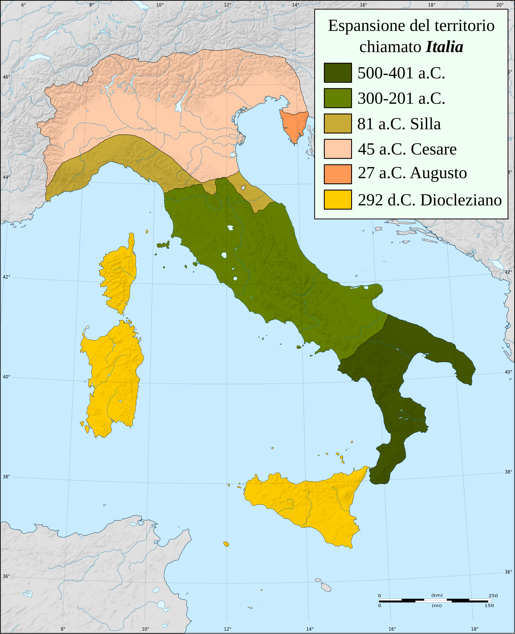
Italiano: Evoluzione geografica dell'Italia nel periodo Romano [1] |
| Date | (UTC) |
| Source |
This file was derived from: RomanItaly.png:  This vector image includes elements that have been taken or adapted from this file: |
| Author |
|
| This is a retouched picture, which means that it has been digitally altered from its original version. Modifications: Vectorized. The original can be viewed here: RomanItaly.png:
|
Licensing
[edit]
I, the copyright holder of this work, hereby publish it under the following licenses:
This file is licensed under the Creative Commons Attribution-Share Alike 3.0 Unported license.
- You are free:
- to share – to copy, distribute and transmit the work
- to remix – to adapt the work
- Under the following conditions:
- attribution – You must give appropriate credit, provide a link to the license, and indicate if changes were made. You may do so in any reasonable manner, but not in any way that suggests the licensor endorses you or your use.
- share alike – If you remix, transform, or build upon the material, you must distribute your contributions under the same or compatible license as the original.

|
Permission is granted to copy, distribute and/or modify this document under the terms of the GNU Free Documentation License, Version 1.2 or any later version published by the Free Software Foundation; with no Invariant Sections, no Front-Cover Texts, and no Back-Cover Texts. A copy of the license is included in the section entitled GNU Free Documentation License. |
You may select the license of your choice.
Original upload log
[edit]
This image is a derivative work of the following images:
- File:RomanItaly.png licensed with Cc-by-sa-3.0, GFDL
- 2010-04-21T20:35:25Z GaiusCrastinus 1240x1472 (1737867 Bytes) new version [[Category:Maps of Italy]]
- 2009-06-30T10:28:14Z GaiusCrastinus 1240x1472 (163569 Bytes) 212--->292
- 2009-06-29T16:26:41Z GaiusCrastinus 1240x1472 (163676 Bytes) corrections
- 2009-06-29T10:40:47Z GaiusCrastinus 1306x1600 (142982 Bytes) {{Information |Description={{it|1=Evoluzione geografica dell'Italia nel periodo Romano [http://italia.onwww.net/italia/testocompleto.htm]}} |Source=Own work by uploader |Author=[[User:GaiusCrastinus|GaiusCrastinus]] |Date=200
Uploaded with derivativeFX
File history
Click on a date/time to view the file as it appeared at that time.
| Date/Time | Thumbnail | Dimensions | User | Comment | |
|---|---|---|---|---|---|
| current | 18:58, 19 June 2013 | | 1,760 × 2,168 (2.28 MB) | Fulvio314 (talk | contribs) | Legend |
| 17:29, 19 June 2013 |  | 1,759 × 2,167 (2.35 MB) | Fulvio314 (talk | contribs) | Reverted to version as of 08:47, 25 May 2013, colors were correct. | |
| 18:15, 3 June 2013 |  | 1,760 × 2,168 (2.36 MB) | Fulvio314 (talk | contribs) | Swap first two colors | |
| 08:47, 25 May 2013 |  | 1,759 × 2,167 (2.35 MB) | Fulvio314 (talk | contribs) | == {{int:filedesc}} == {{Information |Description={{it|1=Evoluzione geografica dell'Italia nel periodo Romano [http://italia.onwww.net/italia/testocompleto.htm]}} |Source={{Derived from|RomanItaly.png|display=50}} |Date=2013-05-25 08:35 (UTC) |Author=*... |
You cannot overwrite this file.
File usage on Commons
The following page uses this file:
File usage on other wikis
The following other wikis use this file:
- Usage on azb.wikipedia.org
- Usage on bg.wikipedia.org
- Usage on fr.wikipedia.org
- Usage on it.wikipedia.org
- Seconda guerra punica
- Guerra sociale
- Sacco di Roma (390 a.C.)
- Battaglia del lago Regillo
- Prima guerra sannitica
- Seconda guerra sannitica
- Terza guerra sannitica
- Battaglia del fiume Allia
- Guerre pirriche
- Foedus Cassianum
- Guerra latina
- Italia romana
- Guerre tra Roma e Veio
- Italia (regione geografica)
- Storia d'Italia
- Guerre romano-celtiche
- Conquista di Rezia ed arco alpino sotto Augusto
- Etimologia del nome Italia
- Roma e le guerre con Equi e Volsci
- Conquista romana della Gallia Cisalpina
- Progetto:Laboratorio grafico/Immagini da migliorare/Archivio risolte/138
- Utente:Francesco Ippolito/Libri/Italia
- Guerre romano-etrusche
- Guerre romano-latine
- Template:Conquista romana dell'Italia
- Storia dell'Italia romana
- Storia militare d'Italia
- Discussioni utente:LukeWiller/Archivio/Archivio46
- Utente:Barjimoa/Sandbox
- Battaglia dello Stretto di Messina (276 a.C.)
- Usage on lv.wikipedia.org
- Usage on nl.wikipedia.org
- Usage on ru.wikipedia.org
- Usage on sh.wikipedia.org
- Usage on sr.wikipedia.org