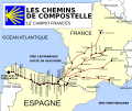
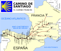
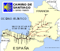
File:Routes de St jacques de Compostelle.svg
From Wikimedia Commons, the free media repository
Jump to navigation
Jump to search

Size of this PNG preview of this SVG file: 712 × 599 pixels. Other resolutions: 285 × 240 pixels | 570 × 480 pixels | 913 × 768 pixels | 1,217 × 1,024 pixels | 2,434 × 2,048 pixels | 1,010 × 850 pixels.
Original file (SVG file, nominally 1,010 × 850 pixels, file size: 119 KB)
File information
Structured data
Captions
Captions
Add a one-line explanation of what this file represents
| DescriptionRoutes de St jacques de Compostelle.svg |
Français : Routes vers St Jacques de Compostelle English: Map of the route of the "French" Way of St. James Español: Mapa de la ruta del Camino de Santiago francés |
| Date | 12/11/2006 |
| Source | Image created by jynus, based on Image:Europe countries.svg by User:Tintazul. |
| Author | historicair 17:25, 16 November 2006 (UTC) |
| Permission (Reusing this file) |
I, the copyright holder of this work, hereby publish it under the following license: This file is licensed under the Creative Commons Attribution-Share Alike 2.5 Generic license.
|
| Other versions |
[edit]
|
This map was improved or created by the Wikigraphists of the Graphic Lab (fr). You can propose images to clean up, improve, create or translate as well. |
File history
Click on a date/time to view the file as it appeared at that time.
| Date/Time | Thumbnail | Dimensions | User | Comment | |
|---|---|---|---|---|---|
| current | 21:47, 23 January 2016 |  | 1,010 × 850 (119 KB) | Augusta 89 (talk | contribs) | Correction de l'emplacement de la majorité des noms localisés sur la carte (principalement en France). Nombreuses corrections typographiques (Clarité -> Charité) et les majuscules en français prennent un accent sur les "E". Utilisation des couleur... |
| 02:09, 19 May 2014 |  | 1,010 × 850 (123 KB) | Vivaelcelta (talk | contribs) | Corrections | |
| 02:03, 19 May 2014 |  | 1,010 × 850 (123 KB) | Vivaelcelta (talk | contribs) | Corrections | |
| 02:02, 19 May 2014 |  | 1,010 × 850 (123 KB) | Vivaelcelta (talk | contribs) | Corrections | |
| 02:00, 19 May 2014 |  | 1,010 × 850 (123 KB) | Vivaelcelta (talk | contribs) | Corrections | |
| 18:17, 16 November 2006 |  | 1,010 × 850 (116 KB) | Historicair (talk | contribs) | ||
| 17:25, 16 November 2006 |  | 1,010 × 850 (114 KB) | Historicair (talk | contribs) | {{Information |Description={{fr|Routes vers St Jacques de Compostelle}} {{en|Map of the route of the "French" Way of St. James}} {{es|Mapa de la ruta del Camino de Santiago francés}} |Source=Image created by User:Tintazul, based on [[:Image:Europe c |
You cannot overwrite this file.
File usage on Commons
The following 10 pages use this file:
- Way of St. James
- User:Chumwa/OgreBot/Potential transport maps/2016 January 21-31
- User:Chumwa/OgreBot/Transport Maps/2016 January 21-31
- User:Chumwa/OgreBot/Travel and communication maps/2016 January 21-31
- File:French Ways of St. James.svg
- File:Routes de St jacques de Compostelle.svg
- File:Ruta del Camino de Santiago Frances.svg
- File:Ruta do Camiño de Santiago francés.png
- File:Rutas do Camiño de Santiago francés.svg
- Template:Other versions/French Ways of St. James
File usage on other wikis
The following other wikis use this file:
- Usage on br.wikipedia.org
- Usage on fr.wikipedia.org
- Usage on he.wikipedia.org
- Usage on hr.wikipedia.org
- Usage on hy.wikipedia.org
- Usage on lb.wikipedia.org
- Usage on oc.wikipedia.org
- Usage on pl.wikipedia.org
- Usage on pt.wikipedia.org
- Usage on ro.wikipedia.org
- Usage on ru.wikipedia.org
- Usage on sh.wikipedia.org
- Usage on sl.wikipedia.org
- Usage on vi.wikipedia.org
Metadata
This file contains additional information such as Exif metadata which may have been added by the digital camera, scanner, or software program used to create or digitize it. If the file has been modified from its original state, some details such as the timestamp may not fully reflect those of the original file. The timestamp is only as accurate as the clock in the camera, and it may be completely wrong.
| Width | 1010 |
|---|---|
| Height | 850 |


