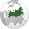
File:Russian Federation (orthographic projection) - Annexed Territories disputed.svg
From Wikimedia Commons, the free media repository
Jump to navigation
Jump to search

Size of this PNG preview of this SVG file: 536 × 537 pixels. Other resolutions: 240 × 240 pixels | 479 × 480 pixels | 767 × 768 pixels | 1,022 × 1,024 pixels | 2,044 × 2,048 pixels.
Original file (SVG file, nominally 536 × 537 pixels, file size: 442 KB)
File information
Structured data
Captions
Captions
Russia on the globe with the annexed territories marked
Россия на глобальной карте мира с аннексированными территориями, отмеченными как заявленные.
Küresel dünya haritasında Rusya'nın ilhak ettiği topraklar iddia edildiği gibi işaretlenmiştir.
Globe terrestre avec la Russie en vert.
Summary
[edit]The factual accuracy of this map or the file name is disputed.
Reason: This map violates NPOV rules because it contains national and political boundaries that are disputed and not currently recognized under international law. For that reason it should not be used on Wikipedia projects where NPOV applies. |  |
| DescriptionRussian Federation (orthographic projection) - Annexed Territories disputed.svg |
English: Russia on the globe with the annexed territories marked as claimed |
| Date | |
| Source | Own work |
| Author | UnixBased |
| Other versions |
|
Licensing
[edit]I, the copyright holder of this work, hereby publish it under the following license:
This file is licensed under the Creative Commons Attribution-Share Alike 4.0 International license.
- You are free:
- to share – to copy, distribute and transmit the work
- to remix – to adapt the work
- Under the following conditions:
- attribution – You must give appropriate credit, provide a link to the license, and indicate if changes were made. You may do so in any reasonable manner, but not in any way that suggests the licensor endorses you or your use.
- share alike – If you remix, transform, or build upon the material, you must distribute your contributions under the same or compatible license as the original.
File history
Click on a date/time to view the file as it appeared at that time.
| Date/Time | Thumbnail | Dimensions | User | Comment | |
|---|---|---|---|---|---|
| current | 13:27, 24 February 2023 |  | 536 × 537 (442 KB) | Stjn (talk | contribs) | Reverted to version as of 23:13, 13 February 2023 (UTC): the file name says 'annexed territories disputed', so it does not include Kuril Islands in its current scope, create a separate file for that purpose |
| 21:08, 17 February 2023 |  | 536 × 537 (442 KB) | Jamie Eilat (talk | contribs) | Please provide some actual sourcing and/or list of countries rather than stating a vague "vast majority of countries". The United States, Ukraine, and European Union (at least) publicly view Japan as having the rightful claim to ownership. And yes, Russia has continuously controlled the islands de-facto since the 40s– that's why the dispute exists. | |
| 23:13, 13 February 2023 |  | 536 × 537 (442 KB) | DecafPotato (talk | contribs) | Reverted to version as of 21:23, 9 January 2023 (UTC) – Yes, the Kuril dispute is ongoing, but the vast majority of countries recognize it as Russian and it has been continuously Russian since the 1940s | |
| 17:35, 9 February 2023 |  | 536 × 537 (442 KB) | Jamie Eilat (talk | contribs) | Reverted to version as of 22:21, 28 October 2022 (UTC) Kuril Islands Dispute is ongoing, and Russian sovereignty is not universally recognized | |
| 21:23, 9 January 2023 |  | 536 × 537 (442 KB) | UnixBased (talk | contribs) | The colour of Kuril Islands is returned to dark green, as it is internationally recognised as part of Russia. | |
| 22:21, 28 October 2022 |  | 536 × 537 (442 KB) | DinoSoupCanada (talk | contribs) | Other version has inaccurate borders. It only shows the right bank of Kherson and smaller, simplified, and inaccurate borders of oblasts. For annexed borders, see File:Ukraine_disputed_regions.svg | |
| 14:37, 25 October 2022 |  | 535 × 535 (474 KB) | Alexassandro (talk | contribs) | Reverted to version as of 10:01, 24 September 2022 (UTC) | |
| 14:36, 25 October 2022 |  | 536 × 537 (442 KB) | Alexassandro (talk | contribs) | Reverted to version as of 15:35, 30 September 2022 (UTC) | |
| 11:28, 25 October 2022 |  | 535 × 535 (474 KB) | Alexassandro (talk | contribs) | Reverted to version as of 10:01, 24 September 2022 (UTC) | |
| 15:35, 30 September 2022 |  | 536 × 537 (442 KB) | Physeters (talk | contribs) | bring back shading |
You cannot overwrite this file.
File usage on Commons
The following 12 pages use this file:
- User talk:Physeters/Archive 2022
- File:Russian Federation (orthographic projection).svg
- File:Russian Federation (orthographic projection) - 2014, 2022 Annexed Territories disputed.svg
- File:Russian Federation (orthographic projection) - All Territorial Disputes.svg
- File:Russian Federation (orthographic projection) - Annexed Territories disputed.svg
- File:Russian Federation (orthographic projection) - Annexed territories as russian core territories.svg
- File:Russian Federation (orthographic projection) - Annexed territories disputed (after 27092022).svg (file redirect)
- File:Russian Federation (orthographic projection) - Crimea disputed.svg
- File:Russian Federation 2014 (orthographic projection) with Crimea.svg
File usage on other wikis
The following other wikis use this file:
- Usage on ace.wikipedia.org
- Usage on ady.wikipedia.org
- Usage on an.wikipedia.org
- Usage on ar.wikipedia.org
- Usage on arz.wikipedia.org
- Usage on av.wikipedia.org
- Usage on azb.wikipedia.org
- Usage on bg.wikipedia.org
- Usage on bxr.wikipedia.org
- Usage on da.wikipedia.org
- Usage on de.wikipedia.org
- Usage on eml.wikipedia.org
- Usage on en.wikipedia.org
- Usage on es.wikipedia.org
- Usage on frr.wikipedia.org
- Usage on fr.wikipedia.org
- Usage on fy.wikipedia.org
- Usage on gag.wikipedia.org
- Usage on gn.wikipedia.org
- Usage on gor.wikiquote.org
- Usage on ha.wikipedia.org
- Usage on hi.wikipedia.org
- Usage on ia.wikipedia.org
- Usage on ilo.wikipedia.org
- Usage on inh.wikipedia.org
- Usage on it.wikipedia.org
- Usage on ja.wikipedia.org
- Usage on ko.wikipedia.org
- Usage on lez.wikipedia.org
- Usage on lld.wikipedia.org
- Usage on mhr.wikipedia.org
- Usage on mi.wikipedia.org
- Usage on mwl.wikipedia.org
- Usage on pap.wikipedia.org
- Usage on pcd.wikipedia.org
- Usage on pt.wikipedia.org
- Usage on scn.wikipedia.org
View more global usage of this file.
Metadata
This file contains additional information such as Exif metadata which may have been added by the digital camera, scanner, or software program used to create or digitize it. If the file has been modified from its original state, some details such as the timestamp may not fully reflect those of the original file. The timestamp is only as accurate as the clock in the camera, and it may be completely wrong.
| Width | 535.50079 |
|---|---|
| Height | 537.35815 |


