File:Russland Autonomie map.png
Jump to navigation
Jump to search
Size of this preview: 800 × 461 pixels. Other resolutions: 320 × 184 pixels | 640 × 369 pixels | 1,024 × 590 pixels | 1,280 × 737 pixels | 2,560 × 1,475 pixels | 4,650 × 2,679 pixels.
Original file (4,650 × 2,679 pixels, file size: 1.2 MB, MIME type: image/png)
Captions
Captions
Add a one-line explanation of what this file represents
| Description |
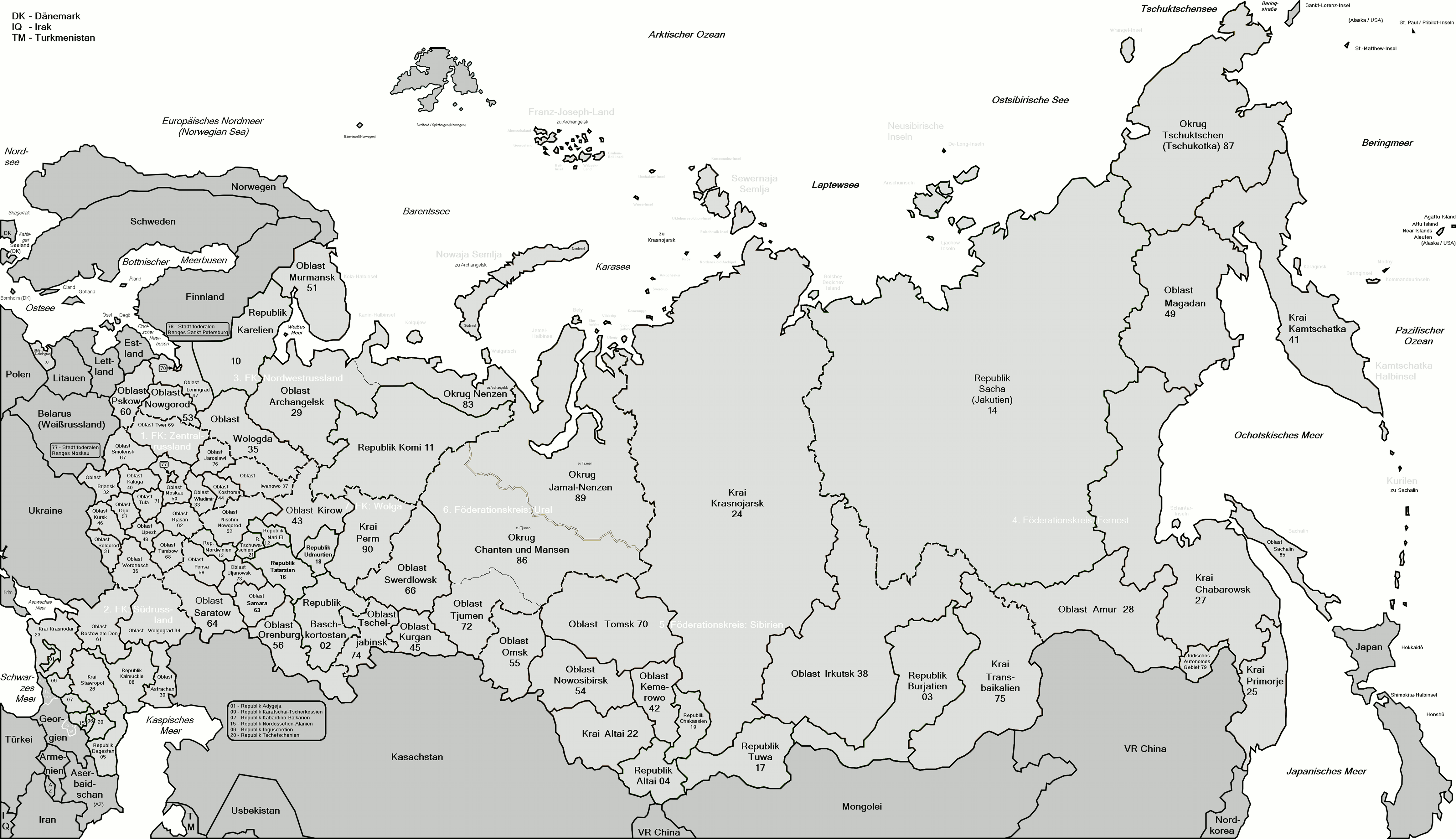
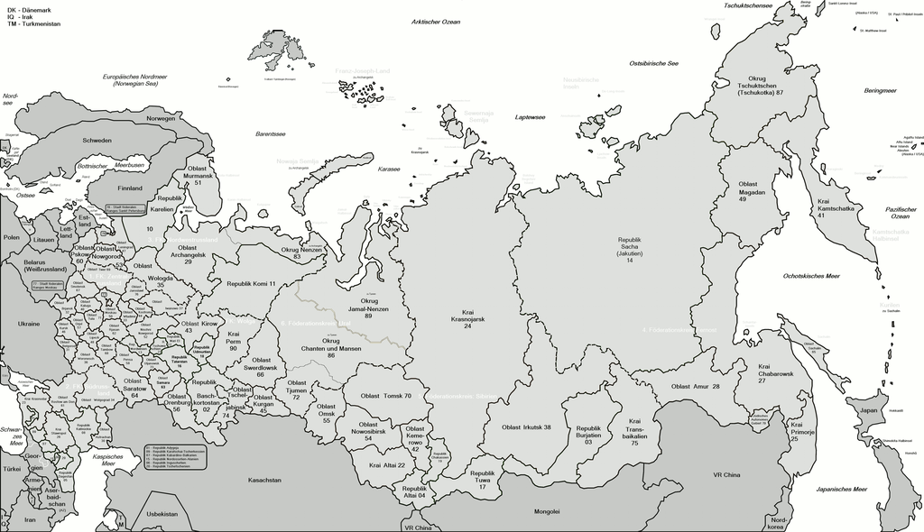
Map of Russia with merged subjects (01.01.2008, last merger Irkutskaya oblast+Ust-Orda Buryat autonomous district.) The subjects are grouped and tagged with their respective ISO 3166-2:RU code for easy creation of derivative maps. |
| Date | (UTC) |
| Source | |
| Author |
|
| This is a retouched picture, which means that it has been digitally altered from its original version. Modifications: add names and numbers, fixing some map bug, new colors and border style, indexed and interlaced. The original can be viewed here: Map of Russian subjects recent.svg:
|
I, the copyright holder of this work, hereby publish it under the following licenses:
This file is licensed under the Creative Commons Attribution 2.5 Generic license.
- You are free:
- to share – to copy, distribute and transmit the work
- to remix – to adapt the work
- Under the following conditions:
- attribution – You must give appropriate credit, provide a link to the license, and indicate if changes were made. You may do so in any reasonable manner, but not in any way that suggests the licensor endorses you or your use.
You may select the license of your choice.
Original upload log
[edit]
This image is a derivative work of the following images:
- File:Map_of_Russian_subjects_recent.svg licensed with Cc-by-2.5, Cc-by-2.5
- 2008-01-17T03:29:40Z Lokal Profil 1092x630 (226515 Bytes) Fixed Chita/Agin-Buryat. Also code cleanup and ID-tagged according to [[:en:ISO 3166-2:RU]]
- 2008-01-03T22:12:01Z Fremantleboy 1092x630 (195867 Bytes)
- 2007-05-24T12:57:17Z Fremantleboy 1092x630 (189700 Bytes) == Beschreibung == {{Information |Description=Map of Russia with merged subjects (01.07.2007) |Source=own work - selbst erstellt |Date=24. May 2007 - 24. Mai 2007 |Author=[[user:fremantleboy]] |Permission= |other
- 2007-05-24T12:39:34Z Fremantleboy 1092x630 (189547 Bytes) == Beschreibung == {{Information |Description=Map of Russia with merged subjects (01.07.2007) |Source=own work - selbst erstellt |Date=24. May 2007 - 24. Mai 2007 |Author=[[user:fremantleboy]] |Permission= |other
Uploaded with derivativeFX
File history
Click on a date/time to view the file as it appeared at that time.
| Date/Time | Thumbnail | Dimensions | User | Comment | |
|---|---|---|---|---|---|
| current | 10:14, 12 February 2009 | | 4,650 × 2,679 (1.2 MB) | Loki de (talk | contribs) | downsize from 5000x2881 to 4650x2679, saveing max thumbnale size |
| 09:21, 12 February 2009 |  | 5,000 × 2,881 (590 KB) | Loki de (talk | contribs) | {{Information |Description=Map of Russia with merged subjects (01.01.2008, last merger Irkutskaya oblast+Ust-Orda Buryat autonomous district.)<br> The subjects are grouped and tagged with their respec |
You cannot overwrite this file.
File usage on Commons
There are no pages that use this file.