File:Rzeczpospolita Rozbiory 2.png
Jump to navigation
Jump to search
Size of this preview: 727 × 599 pixels. Other resolutions: 291 × 240 pixels | 582 × 480 pixels | 932 × 768 pixels | 1,242 × 1,024 pixels | 1,902 × 1,568 pixels.
Original file (1,902 × 1,568 pixels, file size: 296 KB, MIME type: image/png)
Captions
Captions
Add a one-line explanation of what this file represents
Summary
[edit]
|
This historical map image could be re-created using vector graphics as an SVG file. This has several advantages; see Commons:Media for cleanup for more information. If an SVG form of this image is available, please upload it and afterwards replace this template with
{{vector version available|new image name}}.
It is recommended to name the SVG file “Rzeczpospolita Rozbiory 2.svg”—then the template Vector version available (or Vva) does not need the new image name parameter. |
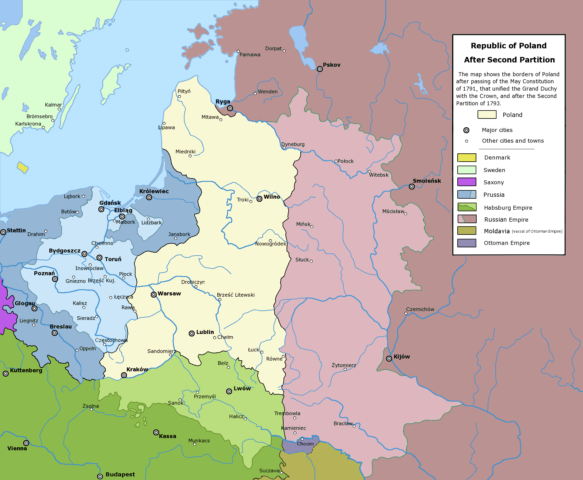
Poland after the Second Partition.
Licensing
[edit]The following is a list of maps created by Halibutt and uploaded to commons, as well as their present and projected derivatives.
| Parent Image | Image | Description | |||||||||||
|---|---|---|---|---|---|---|---|---|---|---|---|---|---|
| Maps by Halibutt | |||||||||||||
| Image:Rzeczpospolita.png | Image:Rzeczpospolita.png | The Republic in 17th and 18th century | |||||||||||
| Image:Rzeczpospolita 1600.png | The Republic after the Treaty of Dywilino | ||||||||||||
| Image:Rzeczpospolita voivodships.png | Voivodships of The Republic | ||||||||||||
| Image:Rzeczpospolita_Potop.png | The Republic during The Deluge and Chmielnicki Uprising, with major battles of the era marked | ||||||||||||
| Magnates and their lands and domains | |||||||||||||
| 1st • 2nd • 3rd | Partitions of Poland | ||||||||||||
| War of the constitution | |||||||||||||
| Image:Rzeczpospolita.xcf | SOURCE FILE - GIMP format | ||||||||||||
| Image:Poland 1939.png | Image:Poland 1939.png | Poland in 1939 | |||||||||||
| Image:Dywizje wrzesien 1.png | Order of Battle on September 1st, during the Polish Defence War of 1939 | ||||||||||||
| Image:Poland 1939.xcf | SOURCE FILE - GIMP format | ||||||||||||
| Image:Polska kontur bialy.png | Image:Polska kontur bialy.png | Contour map of Poland AD 1999, for use with various locator maps | |||||||||||
| Image:Rzeczpospolita 1923.png | Image:Rzeczpospolita 1923.png | Map of Poland 1918-1939, currently under development | |||||||||||
| Image:PBW March 1919.png | Polish-Bolshevik War - fronts in March of 1919 | ||||||||||||
| Image:PBW December 1919.png | Polish-Bolshevik War - fronts in December of 1919 | ||||||||||||
| Image:PBW June 1920.png | Polish-Bolshevik War - fronts in July of 1920 | ||||||||||||
| Image:PBW August 1920.png | Polish-Bolshevik War - fronts in August of 1920 | ||||||||||||
| Polish Defence War of 1939 | |||||||||||||
| Polish areas annexed by Germany, Lithuania, Slovakia and the Soviet Union | |||||||||||||
| German concentration camps in Poland | |||||||||||||
| Curzon line | |||||||||||||
| Major battles of the Polish-Bolshevik War | |||||||||||||
| names • no names | Polish/Czechoslovak/Lithuanian/German/Ukrainian claims in 1920's | ||||||||||||
| Image:Rzeczpospolita Central Lithuania.png | Central Lithuania | ||||||||||||
| Image:Rzeczpospolita Lithuania claims.png | Central Lithuania as compared with other Lithuanian claims | ||||||||||||
| Image:Rzeczpospolita 1789-1920.png | Post-1922 borders compared with the territory of Poland before the partitions | ||||||||||||
| Warsaw Uprising and the Operation Tempest | |||||||||||||
| Poland partitioned between the Soviets and the Germans | |||||||||||||
| Image:Rzeczpospolita 1939 Polish divisions.png | Polish divisions on September 1, 1939 | ||||||||||||
| Home Army inspectorates | |||||||||||||
| Image:Rzeczpospolita 1922.xcf | SOURCE FILE - GIMP format | ||||||||||||
| Image:Rzeczpospolita 1937.svg | Vector version!!!! | layered version available on request | |||||||||||
Since the legal status of the above comment has been questioned, I hereby grant anyone the right to treat it as either a standard copyright notice, invariant section, legal statement, legal advice, friendly suggestion or a mere comment, depending on his or hers own choice. |
|

File history
Click on a date/time to view the file as it appeared at that time.
| Date/Time | Thumbnail | Dimensions | User | Comment | |
|---|---|---|---|---|---|
| current | 03:55, 6 January 2018 | | 1,902 × 1,568 (296 KB) | Alphathon (talk | contribs) | General cleanup |
| 19:28, 18 July 2016 |  | 1,902 × 1,568 (332 KB) | Poeticbent (talk | contribs) | further correction for vision impared | |
| 16:20, 18 July 2016 |  | 1,902 × 1,568 (331 KB) | Poeticbent (talk | contribs) | adjust to match others | |
| 16:14, 18 July 2016 |  | 1,902 × 1,568 (331 KB) | Poeticbent (talk | contribs) | per en:Talk:Partitions of Poland - accessibility for people with color vision impairment, dead space cropped | |
| 14:43, 6 May 2016 |  | 2,000 × 1,568 (213 KB) | Julieta39 (talk | contribs) | Cosmetic changes according with the sources cited in the discussion page of this day. | |
| 14:44, 24 February 2010 |  | 2,000 × 1,568 (195 KB) | Dcoetzee (talk | contribs) | Remove watermark, pngcrush | |
| 01:30, 31 January 2009 |  | 2,000 × 1,568 (281 KB) | Mareklug (talk | contribs) | corrected mistake: legend color for H. Empire was off color (not green but white) | |
| 20:53, 16 February 2006 |  | 2,000 × 1,568 (281 KB) | Tomekpe (talk | contribs) | Corrected mistakes: * Silesia at the time belonged to Prussia, whereas the map shows it belonging to Austria. * Sweden no longer had Estonia. * Denmark no longer had the island off the coast of Estonia. * The Ottoman Empire did not control Hungary and Mo | |
| 21:31, 25 December 2005 |  | 2,000 × 1,568 (284 KB) | Tomekpe (talk | contribs) | Halibutt's graphic with changing polish-russian border (Krasny Horodok area). Also deleted white rectangle. | |
| 13:41, 10 January 2005 |  | 2,000 × 1,568 (286 KB) | Halibutt (talk | contribs) | Poland after the 2nd Partition<br>{{User:Halibutt/maps}}<br>{{User:Halibutt/GFDL}}<br>Category:Maps of Poland<br>Category:Historical maps |
You cannot overwrite this file.
File usage on Commons
The following 4 pages use this file:
File usage on other wikis
The following other wikis use this file:
- Usage on ar.wikipedia.org
- Usage on azb.wikipedia.org
- Usage on be-tarask.wikipedia.org
- Usage on be.wikipedia.org
- Usage on bg.wikipedia.org
- Usage on br.wikipedia.org
- Usage on ca.wikipedia.org
- Usage on cs.wikipedia.org
- Usage on de.wikipedia.org
- Usage on dsb.wikipedia.org
- Usage on el.wikipedia.org
- Usage on en.wikipedia.org
- Usage on es.wikipedia.org
- Usage on et.wikipedia.org
- Usage on fa.wikipedia.org
- Usage on fi.wikipedia.org
- Usage on fr.wikipedia.org
- Usage on gl.wikipedia.org
View more global usage of this file.