File:SBB 2015.svg
From Wikimedia Commons, the free media repository
Jump to navigation
Jump to search

Size of this PNG preview of this SVG file: 800 × 465 pixels. Other resolutions: 320 × 186 pixels | 640 × 372 pixels | 1,024 × 595 pixels | 1,280 × 743 pixels | 2,560 × 1,487 pixels | 1,615 × 938 pixels.
Original file (SVG file, nominally 1,615 × 938 pixels, file size: 2.99 MB)
File information
Structured data
Captions
Captions
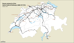
Map of Swiss Federal Railways network
| DescriptionSBB 2015.svg |
Deutsch: Karte des Streckennetzes der Schweizerischen Bundesbahnen (SBB)
English: Map of Swiss Federal Railways network
Français : Carte du réseau des Chemins de fer fédéraux suisses (CFF)
Italiano: Carta della rete ferroviaria delle Ferrovie Federali Svizzere (FFS) |
| Date | |
| Source |
Own work Map was created using Open Street Map |
| Author | de:Benutzer:Pechristener |
| Permission (Reusing this file) |
Map data (c) OpenStreetMap (and) contributors, CC-BY-SA |
| Other versions |
Status 2016 including Gotthard base tunnel:  |
This file is licensed under the Creative Commons Attribution-Share Alike 2.0 Generic license.
- You are free:
- to share – to copy, distribute and transmit the work
- to remix – to adapt the work
- Under the following conditions:
- attribution – You must give appropriate credit, provide a link to the license, and indicate if changes were made. You may do so in any reasonable manner, but not in any way that suggests the licensor endorses you or your use.
- share alike – If you remix, transform, or build upon the material, you must distribute your contributions under the same or compatible license as the original.
This W3C-unspecified vector image was created with Inkscape .
File history
Click on a date/time to view the file as it appeared at that time.
| Date/Time | Thumbnail | Dimensions | User | Comment | |
|---|---|---|---|---|---|
| current | 09:39, 14 February 2015 |  | 1,615 × 938 (2.99 MB) | Pechristener (talk | contribs) | {{Information |Description = {{en|Map of Swiss Federal Railways network.}}{{de|Karte des Streckennetzes der Schweizerische Bundesbahnen.}} |Source = {{own}} Map was created using... |
You cannot overwrite this file.
File usage on Commons
The following 5 pages use this file:
File usage on other wikis
The following other wikis use this file:
- Usage on ca.wikipedia.org
- Usage on cs.wikipedia.org
- Usage on el.wikipedia.org
- Usage on eo.wikipedia.org
- Usage on es.wikipedia.org
- Usage on gl.wikipedia.org
- Usage on te.wikipedia.org
- Usage on tr.wikipedia.org
- Usage on uk.wikipedia.org
- Usage on www.wikidata.org
Metadata
This file contains additional information such as Exif metadata which may have been added by the digital camera, scanner, or software program used to create or digitize it. If the file has been modified from its original state, some details such as the timestamp may not fully reflect those of the original file. The timestamp is only as accurate as the clock in the camera, and it may be completely wrong.
| Width | 1615.05 |
|---|---|
| Height | 937.79 |