File:Sarajevo - 36-44.jpg
Jump to navigation
Jump to search
Size of this preview: 441 × 600 pixels. Other resolutions: 176 × 240 pixels | 353 × 480 pixels | 565 × 768 pixels | 753 × 1,024 pixels | 1,506 × 2,048 pixels | 3,644 × 4,955 pixels.
Original file (3,644 × 4,955 pixels, file size: 5.26 MB, MIME type: image/jpeg)
Captions
Captions
Add a one-line explanation of what this file represents
|
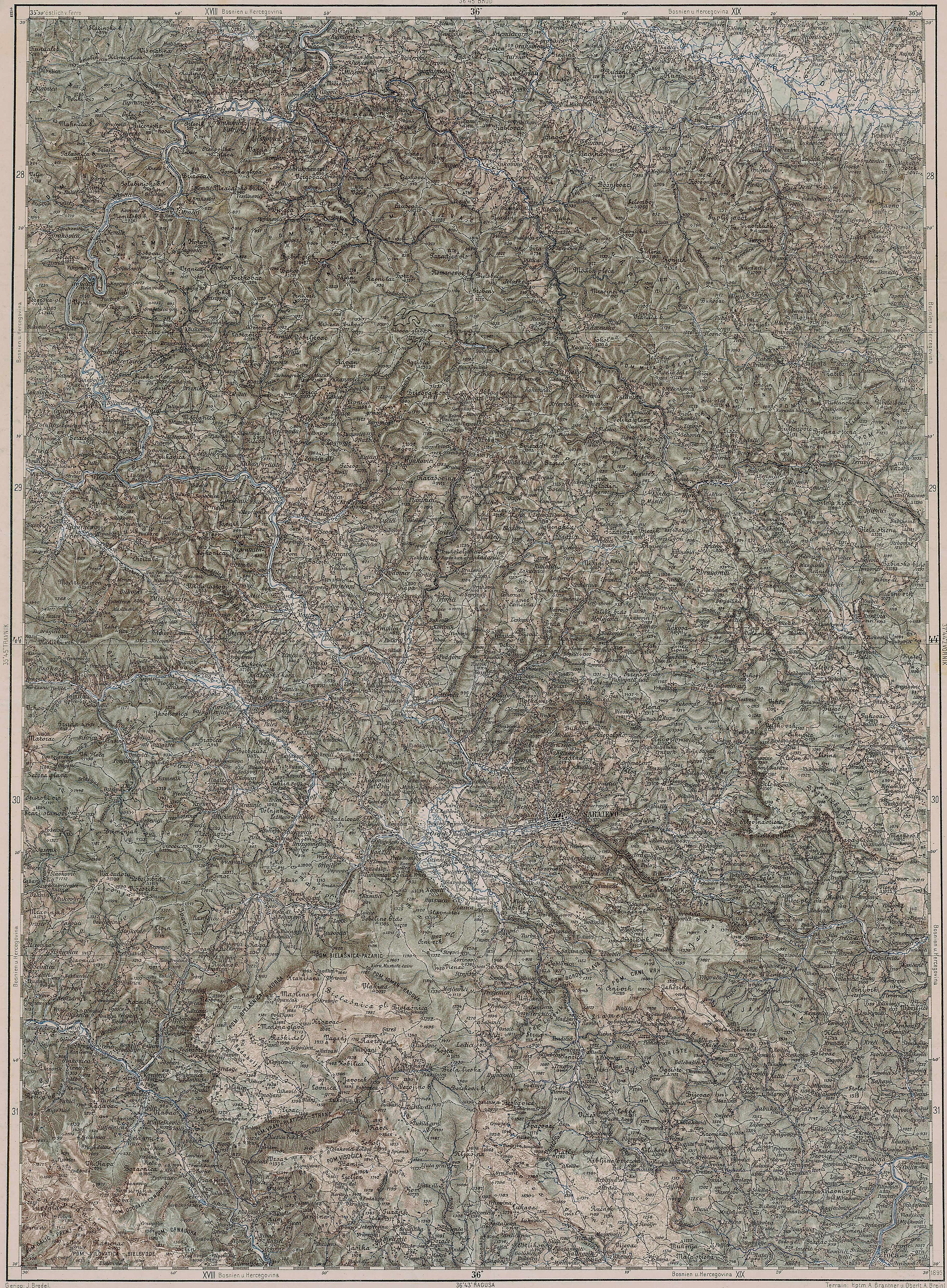
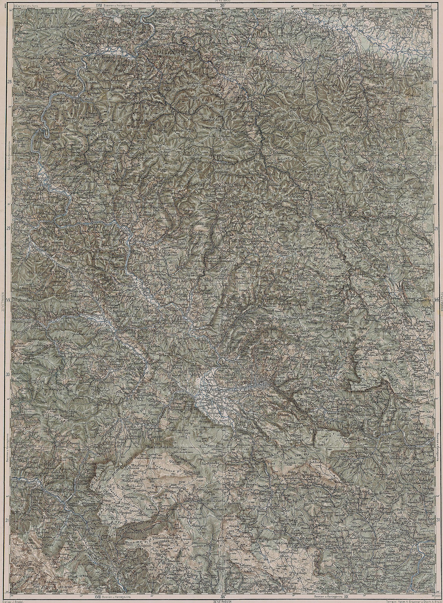
Deutsch: Blatt 36-44 der Generalkarte von Mitteleuropa 1:200.000 der Franzisco-Josephinischen Landesaufnahme, Österreich-Ungarn, ab 1887. Die Blattmitte liegt bei 44° n.Br. und 36° ö.L. (östlich von Ferro, nicht Greenwich!). English: Sheet 36-44 of the General Map of Central Europe, scale 1:200,000, edited 1887 ff. See 3rd Military Mapping Survey of Austria-Hungary for details. The center of the sheet is 44° North, 36° East (east of Ferro, not Greenwich!).
← Nachbarblätter. Klicken Sie auf eine Miniatur, um zu diesem Blatt zu gelangen.
← Neighbouring sheets. Click thumbnail to navigate |


.jpg)
Summary
[edit]
| Description | 3rd Military Mapping Survey of Austria-Hungary - Sarajevo |
| Date | between 1895 and 1914 |
| Source | http://lazarus.elte.hu/hun/moterkep.htm - László ZENTAI |
| Author | Military mapping authority of Austria-Hungary |
Licensing
[edit]
|
This work is in the public domain in its country of origin and other countries and areas where the copyright term is the author's life plus 100 years or fewer. This work is in the public domain in the United States because it was published (or registered with the U.S. Copyright Office) before January 1, 1929. | |
| This file has been identified as being free of known restrictions under copyright law, including all related and neighboring rights. | |
File history
Click on a date/time to view the file as it appeared at that time.
| Date/Time | Thumbnail | Dimensions | User | Comment | |
|---|---|---|---|---|---|
| current | 08:16, 21 March 2007 | | 3,644 × 4,955 (5.26 MB) | Szilas (talk | contribs) | == Összefoglaló == 3rd Military Mapping Survey of Austria-Hungary - Sarajevo Source: http://lazarus.elte.hu/hun/moterkep.htm - László ZENTAI Category:3rd Military Mapping Survey of Austria-Hungary == Licensing == {{PD-old}} |
You cannot overwrite this file.
File usage on Commons
The following 9 pages use this file:
File usage on other wikis
The following other wikis use this file:
- Usage on hu.wikibooks.org