File:Sea of Okhotsk map with state labels.png
From Wikimedia Commons, the free media repository
(Redirected from File:Sea of Okhotsk map.png)

Size of this preview: 657 × 599 pixels. Other resolutions: 263 × 240 pixels | 526 × 480 pixels | 990 × 903 pixels.
Original file (990 × 903 pixels, file size: 84 KB, MIME type: image/png)
File information
Structured data
Captions
Captions
Add a one-line explanation of what this file represents
Kort af Okotskhafi
Северо-Восточная Азия — географический субрегион Азии, северо-восточная часть суши которого и острова ограничены Тихим океаном
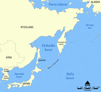
Location of the Sea of Okhotsk
Summary
[edit]| DescriptionSea of Okhotsk map with state labels.png |
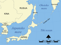
English: This is a map showing the location of the Sea of Okhotsk, with nation states listed. The sea is bordered by Russia and Japan. It also shows parts of the countries and territories that make up the region of Northeast Asia. |
| Date | |
| Source | Own work |
| Author | NormanEinstein |
| Other versions |
Derivative works of this file:
 |
Licensing
[edit]I, the copyright holder of this work, hereby publish it under the following license:

|
Permission is granted to copy, distribute and/or modify this document under the terms of the GNU Free Documentation License, Version 1.2 or any later version published by the Free Software Foundation; with no Invariant Sections, no Front-Cover Texts, and no Back-Cover Texts. A copy of the license is included in the section entitled GNU Free Documentation License.http://www.gnu.org/copyleft/fdl.htmlGFDLGNU Free Documentation Licensetruetrue |
| This file is licensed under the Creative Commons Attribution-Share Alike 3.0 Unported license. | ||
| ||
| This licensing tag was added to this file as part of the GFDL licensing update.http://creativecommons.org/licenses/by-sa/3.0/CC BY-SA 3.0Creative Commons Attribution-Share Alike 3.0truetrue |
File history
Click on a date/time to view the file as it appeared at that time.
| Date/Time | Thumbnail | Dimensions | User | Comment | |
|---|---|---|---|---|---|
| current | 17:13, 23 April 2010 |  | 990 × 903 (84 KB) | Ras67 (talk | contribs) | cropped |
| 10:58, 4 August 2007 |  | 1,000 × 913 (85 KB) | Nihad Hamzic (talk | contribs) | Greatly reduced file size by removing the alpha channel, what enabled me to losslessly reduce the color domain do 8-bit. If alpha channel is indeed needed, then revert this image. | |
| 15:40, 24 October 2005 |  | 1,000 × 913 (408 KB) | NormanEinstein (talk | contribs) | This is a map showing the location of the Sea of Okhotsk. The sea is bordered by Russia and Japan. Created by NormanEinstein, October 24, 2005. {{GFDL-self}} Category:Maps of seas |
You cannot overwrite this file.
File usage on Commons
The following 13 pages use this file:
File usage on other wikis
The following other wikis use this file:
- Usage on ace.wikipedia.org
- Usage on af.wikipedia.org
- Usage on als.wikipedia.org
- Usage on ar.wikipedia.org
- Usage on ast.wikipedia.org
- Usage on avk.wikipedia.org
- Usage on azb.wikipedia.org
- Usage on az.wikipedia.org
- Usage on az.wiktionary.org
- Usage on bat-smg.wikipedia.org
- Usage on be-tarask.wikipedia.org
- Usage on be.wikipedia.org
- Usage on bg.wikipedia.org
- Usage on bn.wikipedia.org
- Usage on br.wikipedia.org
- Usage on bxr.wikipedia.org
- Usage on ca.wikipedia.org
- Usage on ca.wikinews.org
- Usage on ckb.wikipedia.org
- Usage on cs.wikipedia.org
- Usage on cy.wikipedia.org
- Usage on da.wikipedia.org
- Usage on de.wikipedia.org
- Usage on dsb.wikipedia.org
- Usage on el.wikipedia.org
- Usage on en.wikipedia.org
View more global usage of this file.


