File:Sequoyah map.jpg
Jump to navigation
Jump to search

Size of this preview: 546 × 599 pixels. Other resolutions: 219 × 240 pixels | 437 × 480 pixels | 699 × 768 pixels | 933 × 1,024 pixels | 1,865 × 2,048 pixels | 4,390 × 4,820 pixels.
Original file (4,390 × 4,820 pixels, file size: 9.65 MB, MIME type: image/jpeg)
Captions
Captions
Add a one-line explanation of what this file represents
Summary
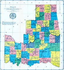
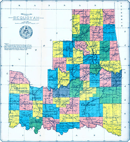
[edit]| Description | This map of the ‘State of Sequoyah’ - complete with a proposed State Seal - was compiled from the USGS Map of Indian Territory (1902), revised to include the county divisions made under direction of Sequoyah Statehood Convention (1905), by D.W. Bolich, a civil engineer at Muskogee. It was found at this page of the McCasland Digital Collection of Early Oklahoma & Indian Territory Maps at the Oklahoma State University Library. |
| Date | |
| Source | http://www.library.okstate.edu/scua/collect/maps/index.htm |
| Author | D.W. Bolich |
| Other versions |
.jpg)

|
This proposed entity map image could be re-created using vector graphics as an SVG file. This has several advantages; see Commons:Media for cleanup for more information. If an SVG form of this image is available, please upload it and afterwards replace this template with
{{vector version available|new image name}}.
It is recommended to name the SVG file “Sequoyah map.svg”—then the template Vector version available (or Vva) does not need the new image name parameter. |


Licensing
[edit]
This media file is in the public domain in the United States. This applies to U.S. works where the copyright has expired, often because its first publication occurred prior to January 1, 1929, and if not then due to lack of notice or renewal. See this page for further explanation.
|
 | |
 |
File history
Click on a date/time to view the file as it appeared at that time.
| Date/Time | Thumbnail | Dimensions | User | Comment | |
|---|---|---|---|---|---|
| current | 05:01, 26 April 2015 | | 4,390 × 4,820 (9.65 MB) | Chumwa (talk | contribs) | some enhancements |
| 08:08, 4 August 2012 |  | 4,152 × 4,632 (3.49 MB) | Mallowtek (talk | contribs) | remove border and improve contrast | |
| 02:37, 16 July 2007 |  | 4,517 × 5,009 (3.91 MB) | Ravedave (talk | contribs) | {{Information |Description= This map of the ‘State of Sequoyah’ - complete with a proposed State Seal - was compiled from the USGS Map of Indian Territory (1902), revised to include the county divisions made under direction of Sequoyah Statehood Conve |
You cannot overwrite this file.
File usage on Commons
The following 3 pages use this file:
File usage on other wikis
The following other wikis use this file:
- Usage on bcl.wikipedia.org
- Usage on be.wikipedia.org
- Usage on ca.wikipedia.org
- Usage on de.wikipedia.org
- Usage on en.wikipedia.org
- Usage on it.wikipedia.org
- Usage on ru.wikipedia.org
- Проект:Тематическая неделя/Неделя южных штатов
- Секвойя (штат)
- Проект:Тематическая неделя/Неделя Соединённых Штатов Америки
- Проект:Тематическая неделя/II Неделя Соединённых Штатов Америки
- Проект:Тематическая неделя/III Неделя Соединённых Штатов Америки
- Проект:Тематическая неделя/IV Неделя Соединённых Штатов Америки
- Проект:Тематическая неделя англоязычных регионов мира/Неделя Соединённых Штатов Америки
- Usage on uk.wikipedia.org