File:Sh location atlantik3.png
Jump to navigation
Jump to search
No higher resolution available.
Sh_location_atlantik3.png (729 × 490 pixels, file size: 87 KB, MIME type: image/png)
Captions
Captions
Add a one-line explanation of what this file represents
| Description |
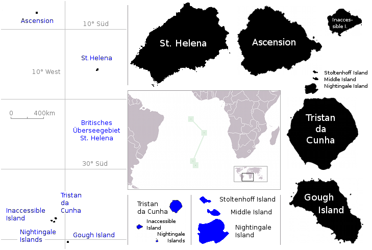
English: Location of the British overseas territory of Saint Helena in the Atlantic Ocean Deutsch: Karte von St. Helena (Deutsch) English: Map of St. Helena (German) |
| Date | (UTC) |
| Source | |
| Author |
|
| This is a retouched picture, which means that it has been digitally altered from its original version. Modifications: cominations for dimensions. The original can be viewed here: St Helena Atlantik.png:
|
| I, the copyright holder of this work, release this work into the public domain. This applies worldwide. In some countries this may not be legally possible; if so: I grant anyone the right to use this work for any purpose, without any conditions, unless such conditions are required by law. |
Original upload log
[edit]
This image is a derivative work of the following images:
- File:LocationStHelena.PNG licensed with PD-self
- 2009-07-23T09:03:17Z Telim tor 465x303 (12567 Bytes) with frame
- 2009-07-23T08:53:25Z Telim tor 465x303 (9212 Bytes) == {{int:filedesc}} == {{Information |Description={{en|Location of the British overseas territory of Saint Helena in the Atlantic Ocean}} |Source={{own}} |Date=2009-07-23 |Author=[[:User:Telim tor|Telim tor]] |Permission= |ot
- File:St_Helena_Atlantik.png licensed with PD-USGov-CIA-WF
- 2007-01-19T09:51:53Z Raymond 328x624 (17911 Bytes) {{Information |Description={{en|Map of St. Helena (German)}} |Source=[[:de:Image:St Helena Atlantik.png]] * 23:34, 3. Mär. 2006 . . Flominator . . 328 x 624 (17.911 Bytes) (Auf eine alte Version zurückgesetzt) * 23:34, 3. M
Uploaded with derivativeFX
File history
Click on a date/time to view the file as it appeared at that time.
| Date/Time | Thumbnail | Dimensions | User | Comment | |
|---|---|---|---|---|---|
| current | 10:29, 4 September 2009 | | 729 × 490 (87 KB) | Loki de (talk | contribs) | {{Information |Description={{en|Location of the British overseas territory of Saint Helena in the Atlantic Ocean}}{{de|Karte von St. Helena (Deutsch)}} {{en|Map of St. Helena (German)}} |Source=*File:LocationStHelena.PNG *[[:File:St_Helena_Atlantik. |
You cannot overwrite this file.
File usage on Commons
The following 12 pages use this file:
- File:United Kingdom (overseas+crown dependencies), administrative divisions - Nmbrs (marker).svg
- File:United Kingdom (overseas+crown dependencies), administrative divisions - Nmbrs (multiple zoom).svg
- File:United Kingdom (overseas+crown dependencies), administrative divisions - Nmbrs (single zoom).svg
- File:United Kingdom (overseas+crown dependencies), administrative divisions - de (marker).svg
- File:United Kingdom (overseas+crown dependencies), administrative divisions - de (multiple zoom).svg
- File:United Kingdom (overseas+crown dependencies), administrative divisions - de (single zoom).svg
- File:United Kingdom (overseas-crown dependencies), administrative divisions - Nmbrs (marker).svg
- File:United Kingdom (overseas-crown dependencies), administrative divisions - Nmbrs (multiple zoom).svg
- File:United Kingdom (overseas-crown dependencies), administrative divisions - Nmbrs (single zoom).svg
- File:United Kingdom (overseas-crown dependencies), administrative divisions - de (marker).svg
- File:United Kingdom (overseas-crown dependencies), administrative divisions - de (multiple zoom).svg
- File:United Kingdom (overseas-crown dependencies), administrative divisions - de (single zoom).svg
,_administrative_divisions_-_Nmbrs_(marker).svg)
,_administrative_divisions_-_Nmbrs_(multiple_zoom).svg)
,_administrative_divisions_-_Nmbrs_(single_zoom).svg)
,_administrative_divisions_-_de_(marker).svg)
,_administrative_divisions_-_de_(multiple_zoom).svg)
,_administrative_divisions_-_de_(single_zoom).svg)
File usage on other wikis
The following other wikis use this file:
- Usage on az.wiktionary.org
- Usage on de.wikipedia.org
- Usage on ig.wikipedia.org