File:Snow-cholera-map.jpg
Jump to navigation
Jump to search
Size of this preview: 613 × 599 pixels. Other resolutions: 246 × 240 pixels | 491 × 480 pixels | 889 × 869 pixels.
Original file (889 × 869 pixels, file size: 248 KB, MIME type: image/jpeg)
Captions
Captions
Add a one-line explanation of what this file represents
Summary
[edit]
| Description |
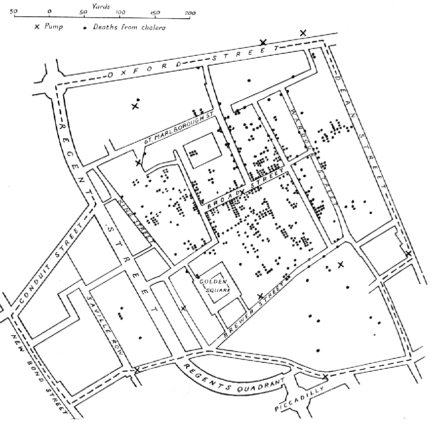
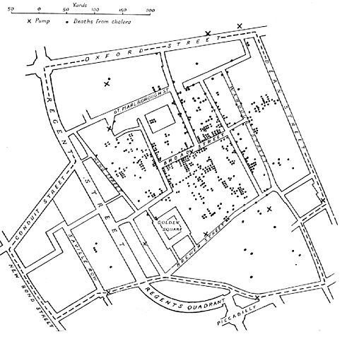
English: A variant of the original map drawn by Dr. John Snow (1813-1858), a British physician who is one of the founders of medical epidemiology, showing cases of cholera in the London epidemics of 1854, clustered around the locations of water pumps.
Español: Mapa original dibujado por el Dr. John Snow (1813-1858), médico inglés precursor de la epidemiología, que muestra los casos de cólera en la epidemia ocurrida en Londres en 1854. Los puntos muestran la localización de las personas afectadas por beber agua de los pozos (cruces)
Português: Mapa original elaborado pelo Dr. John Snow (1813-1858), médico britânico, um dos precursores da epidemiologia. O mapa mostra casos de cólera numa epidemia ocorrida em Londres em 1854. Os pontos indicam a localização de pessoas afetadas pela cólera por consumir água de poços, indicados pelas cruzes.
Nederlands: De originele kaart gemaakt door Dr. John Snow (1813-1858), een Engelse arts en een van de grondleggers van de medische epidemiologie, laat zien waar gevallen van cholera plaatsvonden tijdens de Londense epidemie van 1854, in relatie tot de waterpompen (kruisjes).
Deutsch: Variante einer im Original von Dr. John Snow (1813–1858) gezeichneten Karte. Der britische Arzt war ein Pionier der epidemiologischen Erforschung der Cholera. Die Karte zeigt Cholerafälle bei der Epidemie in London 1854, die sich bei einer Wasserpumpe (an der Broad Street) häufen. |
|||||||||
| Source |
Unknown source Transferred from en.wikipedia to Commons. |
|||||||||
| Creator |
after John Snow |
|||||||||
| Geotemporal data | ||||||||||
| Bounding box |
|
|||||||||
| Georeferencing | ||||||||||
| Other versions | File:Snow-cholera-map-1.jpg, the original | |||||||||
Licensing
[edit]
|
This work is in the public domain in its country of origin and other countries and areas where the copyright term is the author's life plus 70 years or fewer. | |
| This file has been identified as being free of known restrictions under copyright law, including all related and neighboring rights. | |
File history
Click on a date/time to view the file as it appeared at that time.
| Date/Time | Thumbnail | Dimensions | User | Comment | |
|---|---|---|---|---|---|
| current | 11:10, 6 November 2005 | | 889 × 869 (248 KB) | Corso (talk | contribs) | *{{english}}The original map drawn by Dr. John Snow (1813-1858), a British physician who is one of the founders of medical epidemiology, showing cases of cholera in the London epidemics of 1854, clustered around the locations of water pumps. *{{spanish}} |
You cannot overwrite this file.
File usage on Commons
There are no pages that use this file.
File usage on other wikis
The following other wikis use this file:
- Usage on ast.wikipedia.org
- Usage on bg.wikipedia.org
- Usage on bn.wikipedia.org
- Usage on bs.wikipedia.org
- Usage on ca.wikipedia.org
- Usage on cs.wikipedia.org
- Usage on de.wikipedia.org
- Usage on en.wikipedia.org
- Usage on en.wikiversity.org
- Usage on eo.wikipedia.org
- Usage on es.wikipedia.org
- Usage on et.wikipedia.org
- Usage on eu.wikipedia.org
- Usage on ext.wikipedia.org
- Usage on fi.wikipedia.org
- Usage on fr.wikipedia.org
- Usage on hi.wikipedia.org
- Usage on hr.wikipedia.org
- Usage on hu.wikipedia.org
- Usage on io.wikipedia.org
- Usage on it.wikipedia.org
- Usage on ja.wikipedia.org
View more global usage of this file.