File:South Georgia and South Sandwich Islands.png
Jump to navigation
Jump to search
No higher resolution available.
South_Georgia_and_South_Sandwich_Islands.png (337 × 360 pixels, file size: 6 KB, MIME type: image/png)
Captions
Captions
Add a one-line explanation of what this file represents
Summary
[edit]
| Description |
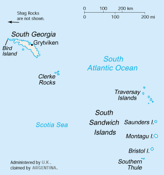
English: Map of South Georgia and the South Sandwich Islands.
Español: Mapa de las Islas Sandwich del Sur e Islas Georgias del Sur. |
| Source | |
| Author | |
| Other versions | Slovene version: File:South Georgia and South Sandwich Islands-sl.png |
This image is in the public domain because it contains materials that originally came from the United States Central Intelligence Agency's World Factbook.
|
 |
derivative works
[edit]
Derivative works of this file:
File history
Click on a date/time to view the file as it appeared at that time.
| Date/Time | Thumbnail | Dimensions | User | Comment | |
|---|---|---|---|---|---|
| current | 16:51, 15 January 2014 | | 337 × 360 (6 KB) | Andy king50 (talk | contribs) | -frame |
| 07:31, 6 November 2005 |  | 341 × 366 (6 KB) | Civvi~commonswiki (talk | contribs) | from en.wiki en:Image:South Georgia and South Sandwich Islands.png {{PD-USGov-CIA-WF}} Category:South Georgia and the South Sandwich Islands |
You cannot overwrite this file.
File usage on Commons
The following 5 pages use this file:
- Atlas of South Georgia and the South Sandwich Islands
- File:South Georgia and South Sandwich Islands He.png
- File:South Georgia and the South Sandwich Islands-CIA WFB Map.png (file redirect)
- File:South Georgia and the South Sandwich Islands on the globe (Antarctica centered).svg
- File:South Georgia and the South Sandwich Islands on the globe (South America centered).svg
.svg)
.svg)
File usage on other wikis
The following other wikis use this file:
- Usage on af.wikipedia.org
- Usage on ang.wikipedia.org
- Usage on ast.wikipedia.org
- Usage on be-tarask.wikipedia.org
- Usage on ca.wikipedia.org
- Usage on ceb.wikipedia.org
- Usage on da.wikipedia.org
- Usage on de.wikipedia.org
- Usage on de.wikivoyage.org
- Usage on dsb.wikipedia.org
- Usage on el.wikipedia.org
- Usage on en.wikipedia.org
- List of islands of South America
- Corbeta Uruguay base
- Second German Antarctic Expedition
- Category:Islands of South Georgia and the South Sandwich Islands
- Category:Islands of South Georgia
- South Georgia and the South Sandwich Islands sovereignty dispute
- Index of South Georgia and the South Sandwich Islands–related articles
- Category:Islands of the South Sandwich Islands
- Usage on en.wikisource.org
- Usage on eo.wikipedia.org
- Usage on es.wikipedia.org
- Usage on fa.wikipedia.org
- Usage on fi.wikipedia.org
- Usage on fr.wikipedia.org
- Usage on fr.wikivoyage.org
- Usage on fy.wikipedia.org
- Usage on gl.wikipedia.org
- Usage on he.wikipedia.org
- Usage on hr.wikipedia.org
- Usage on hsb.wikipedia.org
- Usage on hu.wikipedia.org
View more global usage of this file.