File:Spanish Caribbean Islands in the American Viceroyalties 1600.png
Jump to navigation
Jump to search
Size of this preview: 800 × 477 pixels. Other resolutions: 320 × 191 pixels | 640 × 381 pixels | 1,024 × 610 pixels | 1,600 × 953 pixels.
Original file (1,600 × 953 pixels, file size: 384 KB, MIME type: image/png)
Captions
Captions
Add a one-line explanation of what this file represents
Summary
[edit]| Description |
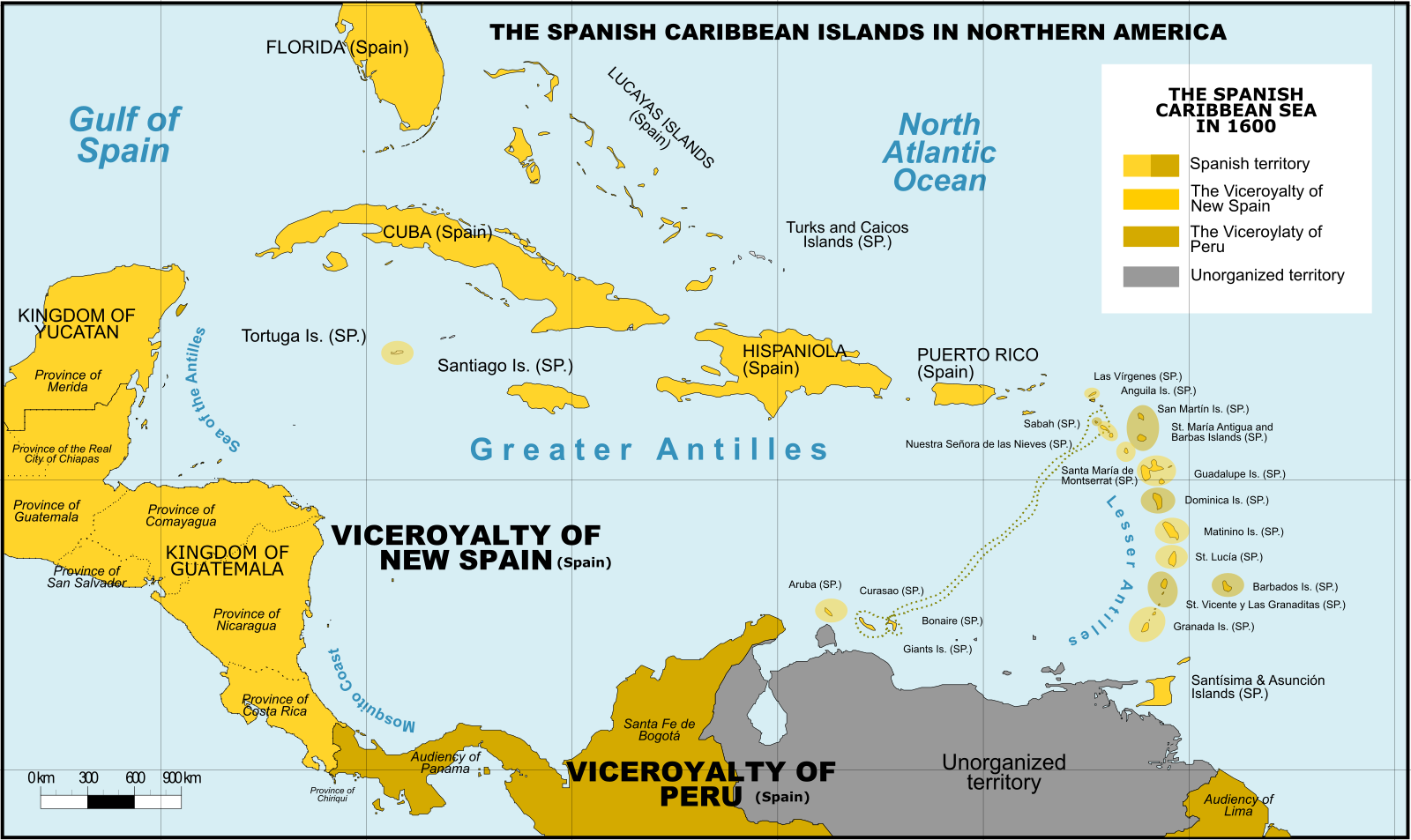
English: Spanish Caribbean Islands 1600
Spanish Overseas territories
|
||
| Date | |||
| Source |
This image was created with Adobe Photoshop. |
||
| Author | Giggette | ||
| Other versions |
|

.png)
.png)
Licensing
[edit]
I, the copyright holder of this work, hereby publish it under the following licenses:
This file is licensed under the Creative Commons Attribution-Share Alike 3.0 Unported license.
- You are free:
- to share – to copy, distribute and transmit the work
- to remix – to adapt the work
- Under the following conditions:
- attribution – You must give appropriate credit, provide a link to the license, and indicate if changes were made. You may do so in any reasonable manner, but not in any way that suggests the licensor endorses you or your use.
- share alike – If you remix, transform, or build upon the material, you must distribute your contributions under the same or compatible license as the original.

|
Permission is granted to copy, distribute and/or modify this document under the terms of the GNU Free Documentation License, Version 1.2 or any later version published by the Free Software Foundation; with no Invariant Sections, no Front-Cover Texts, and no Back-Cover Texts. A copy of the license is included in the section entitled GNU Free Documentation License. |
You may select the license of your choice.
File history
Click on a date/time to view the file as it appeared at that time.
| Date/Time | Thumbnail | Dimensions | User | Comment | |
|---|---|---|---|---|---|
| current | 02:53, 21 November 2016 | | 1,600 × 953 (384 KB) | Giggette (talk | contribs) | DTLS |
| 09:39, 11 December 2015 |  | 1,501 × 894 (354 KB) | Giggette (talk | contribs) | Spanish names | |
| 19:05, 7 May 2014 |  | 1,499 × 893 (352 KB) | Giggette (talk | contribs) | Viceroyalty of Peru | |
| 16:18, 7 May 2014 |  | 1,500 × 981 (359 KB) | Giggette (talk | contribs) | Details | |
| 19:11, 3 May 2014 |  | 1,622 × 1,061 (420 KB) | Giggette (talk | contribs) | Details | |
| 06:16, 3 May 2014 |  | 1,622 × 1,061 (384 KB) | Giggette (talk | contribs) | {{Information |Description ={{en|1=Spanish Caribbean Islands 1600}} |Source ={{own}} |Author =Giggette |Date = |Permission = |other_versions = }} |
You cannot overwrite this file.
File usage on Commons
The following 8 pages use this file:
- User:Giggette
- User:Giggette/cylindrical maps
- File:Mexico 1824 (equirectangular projection).png
- File:Second Mexican Empire (equirectangular projection).png
- File:Spanish Caribbean Islands in the American Viceroyalties 1600.png
- File:Viceroyalty of the New Spain 1800 (without Philippines).png
- File:Viceroyalty of the New Spain 1819 (without Philippines).png
- Category:Captaincy General of Guatemala
.png)
.png)
File usage on other wikis
The following other wikis use this file:
- Usage on af.wikipedia.org
- Usage on azb.wikipedia.org
- Usage on bn.wikipedia.org
- Usage on ca.wikipedia.org
- Usage on cs.wikipedia.org
- Usage on da.wikipedia.org
- Usage on en.wikipedia.org
- Usage on es.wikipedia.org
- Usage on et.wikipedia.org
- Usage on fa.wikipedia.org
- Usage on fr.wikipedia.org
- Usage on ht.wikipedia.org
- Usage on hu.wikipedia.org
- Usage on hy.wikipedia.org
- Usage on hyw.wikipedia.org
- Usage on id.wikipedia.org
- Usage on it.wikipedia.org
- Usage on ja.wikipedia.org
- Usage on la.wikipedia.org
- Usage on no.wikipedia.org
- Usage on pl.wikipedia.org
- Usage on pt.wikipedia.org
- Usage on ru.wikipedia.org
View more global usage of this file.
Metadata
Categories:
- Maps showing 1600
- Maps of the history of the Caribbean
- 1600 in North America
- Maps of the Captaincy General of Cuba
- Maps of subdivisions of the Viceroyalty of New Spain
- Maps of the Viceroyalty of Peru
- Maps of the Captaincy General of Guatemala
- Maps of the Viceroyalty of New Granada
- Maps of the Spanish Americas
- Maps of colonial North America
- Maps of the Captaincy General of Puerto Rico
- Maps of the Captaincy General of Santo Domingo
- Maps of the Captaincy General of Yucatan
- 1600s maps of the Caribbean