File:Sprachen Europas 1990.png
Jump to navigation
Jump to search

Size of this preview: 296 × 600 pixels. Other resolutions: 118 × 240 pixels | 237 × 480 pixels | 379 × 768 pixels | 1,248 × 2,528 pixels.
Original file (1,248 × 2,528 pixels, file size: 94 KB, MIME type: image/png)
Captions
Captions
Add a one-line explanation of what this file represents
This image was copied from wikipedia:de. The original description was:
| Description |
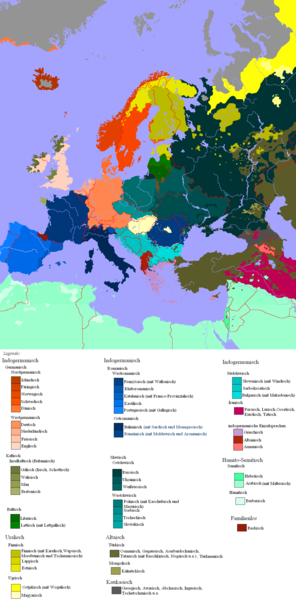
Deutsch: Darstellungskarte mit den europäischen Sprachfamilien um 1990 English: Languages in Europe. |
| Date | |
| Source | de.wikipedia uploaded by Postmann Michael. No further sources are cited. The situation as depicted in this map needs verification, and may need to be corrected. |
| Author | Postmann Michael |
| |
This work has been released into the public domain by its author, Postmann Michael, at the English Wikipedia project. This applies worldwide. In case this is not legally possible: |
| date/time | username | edit summary |
|---|---|---|
| 02:39, 23. Jul 2005 | Postmann Michael | (* Beschreibung: Darstellungskarte mit den europäischen Sprachfamilien um 1990 * Quelle: selbst erstellt * Lizenzstatus: Public Domain {{PD}}) |
File history
Click on a date/time to view the file as it appeared at that time.
| Date/Time | Thumbnail | Dimensions | User | Comment | |
|---|---|---|---|---|---|
| current | 10:44, 6 November 2014 | | 1,248 × 2,528 (94 KB) | Kopiersperre (talk | contribs) | optipng |
| 21:54, 16 June 2011 |  | 1,248 × 2,528 (245 KB) | Maphobbyist (talk | contribs) | Check | |
| 20:06, 15 June 2011 |  | 1,248 × 2,528 (224 KB) | Maphobbyist (talk | contribs) | Breton is only widely spoken in western Brittany. Occitan is not widely spoken as to cover the whole of southern France. Also wrong coloring for Talysh spoken in southern Azerbaijan which is an Iranian language while Lezgin in northern Azerbaijan and sout | |
| 02:17, 25 January 2011 |  | 1,248 × 2,528 (236 KB) | IJA (talk | contribs) | Reverted to version as of 23:02, 23 November 2007 | |
| 17:37, 23 April 2010 |  | 1,248 × 2,528 (283 KB) | AnOicheGhealai (talk | contribs) | Edited Iceland: there are people who live in the center, less basque speakers in France, and less Breton speakers in eastern region of Brittany, French is spoken in Cor. | |
| 23:02, 23 November 2007 |  | 1,248 × 2,528 (236 KB) | Mirko30 (talk | contribs) | corrected some obvious mistakes in the Balkans region | |
| 12:42, 2 May 2006 |  | 1,248 × 2,528 (224 KB) | Crux (talk | contribs) | This image was copied from wikipedia:de. The original description was: {{Information| |Description=Darstellungskarte mit den europäischen Sprachfamilien um 1990 |Source=de.wikipedia uploaded by Postmann Michael |Date=20 |
You cannot overwrite this file.
File usage on Commons
The following 4 pages use this file:
File usage on other wikis
The following other wikis use this file:
- Usage on ar.wikipedia.org
- Usage on en.wikipedia.org
- Usage on eo.wikipedia.org
- Usage on frr.wikipedia.org
- Usage on stq.wikipedia.org
.png)