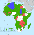
File:States and territories of Africa.svg

Original file (SVG file, nominally 1,564 × 1,633 pixels, file size: 265 KB)
Captions
Captions
Summary
[edit]| DescriptionStates and territories of Africa.svg |
Русский: Государства, колонии и зависимые территории Африки |
||
| Date | |||
| Source |
 Map: |
||
| Author | Kaidor | ||
| SVG development InfoField |
|
Licensing
[edit]- You are free:
- to share – to copy, distribute and transmit the work
- to remix – to adapt the work
- Under the following conditions:
- attribution – You must give appropriate credit, provide a link to the license, and indicate if changes were made. You may do so in any reasonable manner, but not in any way that suggests the licensor endorses you or your use.
- share alike – If you remix, transform, or build upon the material, you must distribute your contributions under the same or compatible license as the original.
File history
Click on a date/time to view the file as it appeared at that time.
| Date/Time | Thumbnail | Dimensions | User | Comment | |
|---|---|---|---|---|---|
| current | 16:52, 20 February 2024 |  | 1,564 × 1,633 (265 KB) | Pacha Tchernof (talk | contribs) | обновление по запросу |
| 22:31, 1 January 2023 |  | 1,564 × 1,633 (265 KB) | Pacha Tchernof (talk | contribs) | Возвращение красного цвета — Лесото | |
| 13:21, 26 December 2022 |  | 1,564 × 1,633 (265 KB) | Pacha Tchernof (talk | contribs) | Updated per request | |
| 23:05, 7 September 2022 |  | 1,564 × 1,633 (268 KB) | Pacha Tchernof (talk | contribs) | Кабо-Верде, регион «Матабелеленд», Канарские острова → в зелёный | |
| 08:08, 26 June 2022 |  | 512 × 535 (220 KB) | Pacha Tchernof (talk | contribs) | Бенин и Экваториальная Гвинея → в зелёный | |
| 11:59, 9 April 2022 |  | 1,564 × 1,633 (268 KB) | Pacha Tchernof (talk | contribs) | Обновление карты на 9 апреля 2022 года (Ранее было заявлено, что не были отмечены Суверенные территории Испании, по факту, об этой неделе есть лишь заготовка, но не подготовленная неделя для проведения, насколько мне видно из текста заготовки) | |
| 15:04, 22 March 2022 |  | 1,564 × 1,633 (268 KB) | Pacha Tchernof (talk | contribs) | Обновление карты за весь 2021 год (2022 год не учтён. Также не отмечены Суверенные территории Испании) | |
| 15:00, 16 January 2021 |  | 1,564 × 1,633 (268 KB) | Kaidor (talk | contribs) | В зелёный → Мозамбик, в красный → Малави | |
| 20:32, 29 December 2020 |  | 1,564 × 1,633 (267 KB) | Kaidor (talk | contribs) | В зелёный → Уганду, Камерун и Нижний Египет. | |
| 17:15, 20 July 2020 |  | 1,564 × 1,633 (268 KB) | Kaidor (talk | contribs) | В зелёный → Тунис. В красный → Ливию. |
You cannot overwrite this file.
File usage on Commons
The following 3 pages use this file:
File usage on other wikis
The following other wikis use this file:
- Usage on ru.wikipedia.org
- Обсуждение участника:Kaidor/Архив/7
- Проект:Графическая мастерская/Заявки/Архив/2022/03
- Проект:Графическая мастерская/Заявки/Архив/2022/12
- Проект:Графическая мастерская/Заявки/Архив/2023/11
- Проект:Графическая мастерская/Заявки/Архив/2024/01
- Проект:Графическая мастерская/Заявки/Архив/2024/07
- Проект:Графическая мастерская/Заявки/Архив/2024/09
Metadata
This file contains additional information such as Exif metadata which may have been added by the digital camera, scanner, or software program used to create or digitize it. If the file has been modified from its original state, some details such as the timestamp may not fully reflect those of the original file. The timestamp is only as accurate as the clock in the camera, and it may be completely wrong.
| Width | 1563.5908 |
|---|---|
| Height | 1633.1915 |