File:Stielers Handatlas 1891 55 Ausschnitt Gaurisankar.jpg
Jump to navigation
Jump to search
No higher resolution available.
Stielers_Handatlas_1891_55_Ausschnitt_Gaurisankar.jpg (559 × 322 pixels, file size: 29 KB, MIME type: image/jpeg)
Captions
Captions
Add a one-line explanation of what this file represents
| Description |
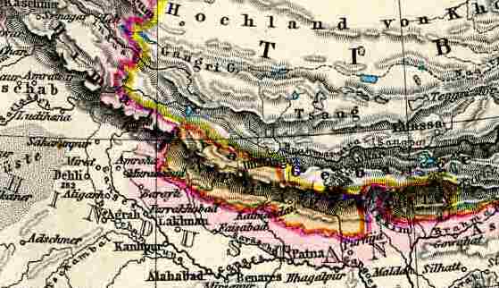
Deutsch: Ausschnitt aus Stielers Handatlas 1891, S. 55, Tafel Asien. Beispiel für einen im deutschsprachigen Raum verbreiteten Irrtum, der höchste Berg der Welt hieße Gauri Sankar. |
| Date | (UTC) |
| Source | |
| Author |
|
| This is a retouched picture, which means that it has been digitally altered from its original version. Modifications: ausschnitt. The original can be viewed here: Stielers Handatlas 1891 55.jpg:
|
|
The author died in Stielers Handatlas 1891, so this work is in the public domain in its country of origin and other countries and areas where the copyright term is the author's life plus 100 years or fewer. This work is in the public domain in the United States because it was published (or registered with the U.S. Copyright Office) before January 1, 1929. | |
| This file has been identified as being free of known restrictions under copyright law, including all related and neighboring rights. | |
Original upload log
[edit]
This image is a derivative work of the following images:
- File:Stielers_Handatlas_1891_55.jpg licensed with PD-old, Stielers Handatlas 1891
- 2006-11-21T17:42:42Z Poccil 3900x3187 (1361226 Bytes) {{Stielers Handatlas 1891|54|56|Asien|Asia}} [[Category:Old maps of Asia]]
Uploaded with derivativeFX
| Annotations | This image is annotated: View the annotations at Commons |
File history
Click on a date/time to view the file as it appeared at that time.
| Date/Time | Thumbnail | Dimensions | User | Comment | |
|---|---|---|---|---|---|
| current | 15:52, 15 January 2010 | | 559 × 322 (29 KB) | Rupert Pupkin (talk | contribs) | {{Information |Description={{Ausschnitt aus Stielers Handatlas 1895, S. 55, Tafel Asien. Beispiel für einen im deutschsprachigen Raum verbreiteten Irrtum, der höchste Berg der Welt hieße Gauri Sankar. |Source= |
You cannot overwrite this file.
File usage on Commons
There are no pages that use this file.
File usage on other wikis
The following other wikis use this file:
- Usage on de.wikipedia.org
- Usage on nds.wikipedia.org
- Usage on sv.wikipedia.org