File:Swedish highspeed rail map 2010.png
Jump to navigation
Jump to search
Size of this preview: 365 × 599 pixels. Other resolutions: 146 × 240 pixels | 450 × 739 pixels.
Original file (450 × 739 pixels, file size: 531 KB, MIME type: image/png)
Captions
Captions
Add a one-line explanation of what this file represents
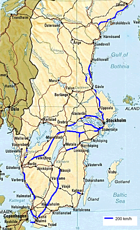
| Description | Map of Swedish railway lines having 200 km/h as maximum speed, and being used at that speed, as of end 2010. |
| Date | (UTC) |
| Source | |
| Author |
|
| Other versions | Derivative works of this file: Swedish highspeed rail map 2012.png |
| This is a retouched picture, which means that it has been digitally altered from its original version. Modifications: Updates for 2009-2010 changes. The original can be viewed here: Swedish highspeed rail map 2008 by BIL.png:
|
I, the copyright holder of this work, hereby publish it under the following license:
| I, the copyright holder of this work, release this work into the public domain. This applies worldwide. In some countries this may not be legally possible; if so: I grant anyone the right to use this work for any purpose, without any conditions, unless such conditions are required by law. |
Original upload log
[edit]
This image is a derivative work of the following images:
- File:Swedish_highspeed_rail_map_2008_by_BIL.png licensed with PD-self
- 2009-07-12T09:56:44Z Tydal 450x609 (403222 Bytes) Tagit bort strax norr om Gävle som inte är 200. Lagt till: Holmsveden-Mo Grindar Västerås N-Västerås C Västerås V-Kolbäck Jädersbruk-Alväng-Hovsta Öxnered-Trollhättan Flunbo-Torbacken Källa: Banverket
- 2009-07-12T09:53:57Z Tydal 450x609 (403222 Bytes) Tagit bort strax norr om Gävle som inte är 200. Lagt till: Holmsveden-Mo Grindar Västerås N-Västerås C Västerås V-Kolbäck Jädersbruk-Alväng-Hovsta Öxnered-Trollhättan Flunbo-Torbacken Källa: Banverket
- 2009-07-12T09:53:29Z Tydal 450x609 (403222 Bytes) Tagit bort strax norr om Gävle som inte är 200. Lagt till: Holmsveden-Mo Grindar Västerås N-Västerås C Västerås V-Kolbäck Jädersbruk-Alväng-Hovsta Öxnered-Trollhättan Flunbo-Torbacken
- 2008-05-10T18:45:17Z BIL 450x609 (393347 Bytes) {{Information |Description=Map of Swedish railway lines having 200 km/h as maximum speed also being used. |Source=self-made map. Information source: 1.Info about which lines have 200 km/h from personal travel experience, time
Uploaded with derivativeFX
File history
Click on a date/time to view the file as it appeared at that time.
| Date/Time | Thumbnail | Dimensions | User | Comment | |
|---|---|---|---|---|---|
| current | 17:44, 12 November 2010 | | 450 × 739 (531 KB) | BIL (talk | contribs) | {{Information |Description=Map of Swedish railway lines having 200 km/h as maximum speed, and being used at that speed, as of end 2010. |Source=*File:Swedish_highspeed_rail_map_2008_by_BIL.png |Date=2010-11-12 17:38 (UTC) |Author=*[[:File:Swedish_hi |
You cannot overwrite this file.
File usage on Commons
There are no pages that use this file.
File usage on other wikis
The following other wikis use this file: