File:Symphyotrichum amethystinum distribution.png
Jump to navigation
Jump to search
Size of this preview: 681 × 599 pixels. Other resolutions: 273 × 240 pixels | 545 × 480 pixels | 873 × 768 pixels | 1,084 × 954 pixels.
Original file (1,084 × 954 pixels, file size: 181 KB, MIME type: image/png)
Captions
Captions
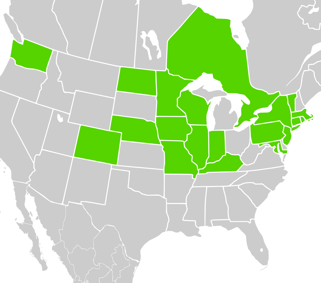
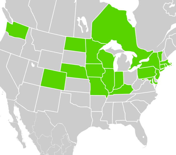
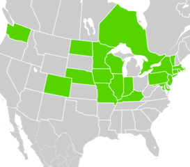
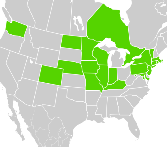
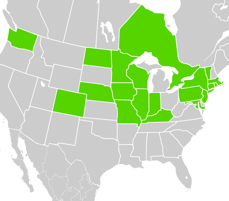
Recorded occurrences of Symphyotrichum × amethystinum in North America by province and state
Summary
[edit]
| Description |
English: Recorded occurrences of Symphyotrichum × amethystinum in North America by province and state: Ontario (Canada) and Colorado, Connecticut, Illinois, Indiana, Iowa, Kentucky, Maryland, Massachusetts, Minnesota, Missouri, Nebraska, New Jersey, New York, North Dakota, Pennsylvania, Rhode Island, Vermont, Washington, and Wisconsin (US). Data source: http://plantsoftheworldonline.org/taxon/urn:lsid:ipni.org:names:981926-1 |
| Date | (UTC) |
| Source |
This file was derived from: North America second level political division 2 and Greenland.svg:  |
| Author | |
| Permission (Reusing this file) |
This file is licensed under the Creative Commons Attribution-Share Alike 2.5 Generic license.
|
| This is a retouched picture, which means that it has been digitally altered from its original version. Modifications: Some states and provinces shaded green. The original can be viewed here: North America second level political division 2 and Greenland.svg:
|
Licensing
[edit]
I, the copyright holder of this work, hereby publish it under the following license:
This file is licensed under the Creative Commons Attribution-Share Alike 2.5 Generic license.
- You are free:
- to share – to copy, distribute and transmit the work
- to remix – to adapt the work
- Under the following conditions:
- attribution – You must give appropriate credit, provide a link to the license, and indicate if changes were made. You may do so in any reasonable manner, but not in any way that suggests the licensor endorses you or your use.
- share alike – If you remix, transform, or build upon the material, you must distribute your contributions under the same or compatible license as the original.
Original upload log
[edit]
This image is a derivative work of the following images:
- File:North America second level political division 2 and Greenland.svg licensed with Cc-by-sa-2.5
- 2008-03-18T13:57:36Z CarolSpears 1789x2154 (375406 Bytes) minor validation problems repaired
- 2008-03-18T13:41:52Z CarolSpears 1789x2154 (375406 Bytes) {{Information |Description={{en|Map of North America and its second-level political divisions. Canadian provinces, US and Mexican states. Canada, Mexico, United States. Non-contiguous parts of a states/provinces are "grouped
Uploaded with derivativeFX
File history
Click on a date/time to view the file as it appeared at that time.
| Date/Time | Thumbnail | Dimensions | User | Comment | |
|---|---|---|---|---|---|
| current | 19:34, 14 September 2021 | | 1,084 × 954 (181 KB) | Eewilson (talk | contribs) | Cropped 10 % horizontally, 6 % vertically using CropTool with precise mode. |
| 21:26, 30 August 2021 |  | 1,208 × 1,012 (228 KB) | Eewilson (talk | contribs) | == {{int:filedesc}} == {{Information |Description={{en|Map of North America and its second-level political divisions. Canadian provinces and territories, US and Mexican states. Canada, Mexico, United States. Non-contiguous parts of a states/provinces are "grouped" together with the main area of the state/provinces, so any state/provinces can be coloured in completion with one click anywhere on the state/provinces's area. Also, all states/provinces have a "id" attached to them, making them e... |
You cannot overwrite this file.
File usage on Commons
The following page uses this file:
File usage on other wikis
The following other wikis use this file:
- Usage on en.wikipedia.org
- Usage on species.wikimedia.org
- Usage on www.wikidata.org