File:Syria and Iraq 2014-onward War map.png
Jump to navigation
Jump to search
Size of this preview: 785 × 600 pixels. Other resolutions: 314 × 240 pixels | 628 × 480 pixels | 1,005 × 768 pixels | 1,280 × 978 pixels | 2,560 × 1,956 pixels | 4,501 × 3,439 pixels.
Original file (4,501 × 3,439 pixels, file size: 1.75 MB, MIME type: image/png)
Captions
Captions
Add a one-line explanation of what this file represents

|
This file has been superseded by Syrian, Iraqi, and Lebanese insurgencies.png. It is recommended to use the other file. Please note that deleting superseded images requires consent.
|

|
Summary
[edit]| Description |
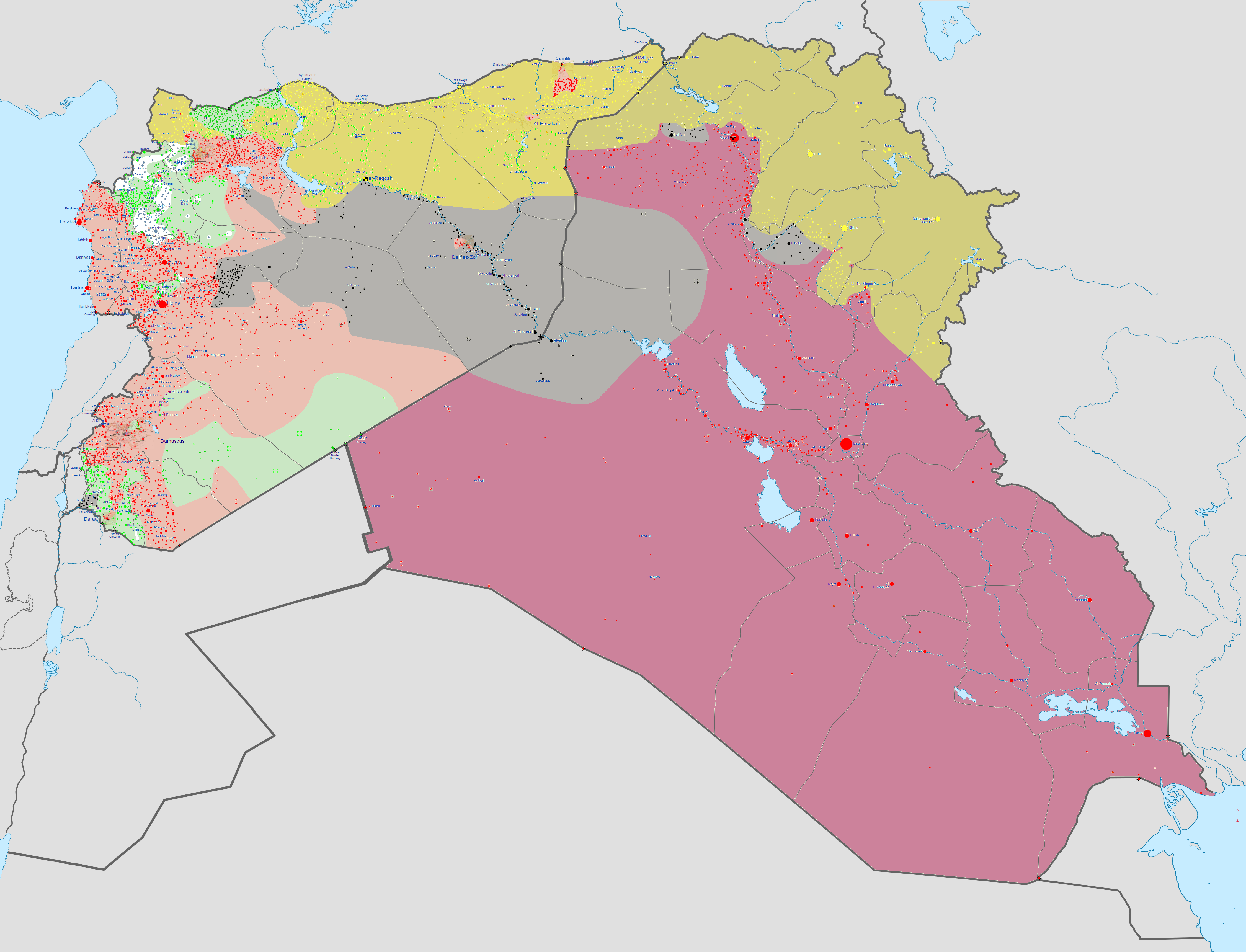
Azərbaycanca: Suriya vətəndaş müharibəsi və İraq müqaviməti (2011-h.h.) xəritəsi
İraq Şam İslam Dövləti (İŞİD)
Mübahisəli ərazi Català: Mapa de la w:ca:Guerra civil siriana i Guerra civil iraquiana
Controltat per la w:ca:Oposició síria
Controltat pel w:ca:Govern de Síria
Controltat pel w:ca:Govern d'Iraq
Controltat per l'w:ca:Estat Islàmic (EI)
Controltat per w:ca:Front Al-Nusra
Controltat pels Kurds sirians
Controltat pels Kurds iraquians
Territoris en disputa Čeština: Mapa občanské války v Sýrii a iracké krize
Pod kontrolou syrské opozice
Pod kontrolou syrské vlády
Pod kontrolou irácké vlády
Pod kontrolou Islámského státu
Pod kontrolou fronty an-Nusrá
Pod kontrolou syrských Kurdů
Pod kontrolou iráckých Kurdů
Sporná území Dansk: Kort over Borgerkrigen i Syrien og Islamisk Stats krig i Irak
Kontrolleret af den syriske opposition
Kontrolleret af den syriske regering
Kontrolleret af den irakiske regering
Kontrolleret af Islamisk Stat (ISIS / ISIL / IS)
Kontrolleret af al-Nusra-Fronten
Kontrolleret af syriske kurdere
Kontrolleret af Irakisk Kurdistan
Situationen uklar Deutsch: Karte des Bürgerkriegs in Syrien und des Aufstands im Irak
Kontrolliert von syrischen Rebellen
Kontrolliert von der syrischen Regierung
Kontrolliert von der irakischen Regierung
Kontrolliert vom Islamischen Staat (IS)
Kontrolliert von der al-Nusra-Front
Kontrolliert von den syrischen Kurden
Kontrolliert von den irakischen Kurden
Umstrittene Gebiete English: Map of the Syrian Civil War and the Iraq War (2014–present).
Controlled by the Syrian opposition
Controlled by the Syrian government
Controlled by the Iraqi government
Controlled by the Islamic State of Iraq and the Levant (ISIL)
Controlled by Tahrir al-Sham (HTS)
Controlled by Syrian Kurdistan
Controlled by Iraqi Kurdistan
Español: Mapa de la Guerra Civil Siria y la Guerra de Irak.
Controlado por los rebeldes sirios
Controlado por el gobierno sirio
Controlado por el gobierno iraquí
Controlado por el Estado Islámico de Irak y el Levante (ISIL)
Controlado por el Frente Al-Nusra
Controlado por los kurdos sirios
Controlado por los kurdos iraquíes
Zonas en disputa Esperanto: Mapo de la Milito Civila Siria kaj la Gerilo Iraka.
Regata de siriaj ribeluloj
Regata de la siria registaro
Regata de la iraka registaro
Regata de la Islama Ŝtato de Irako kaj la Levantenio (ISIL)
Regata de la Fronto al-Nusra
Regata de la siriaj kurdoj
Regata de la irakaj kurdoj
Tero pridisputata Français : Carte actualisée de la guerre d'Irak et de la guerre civile syrienne.
Contrôlé par l'Armée syrienne libre et le Front islamique
Contrôlé par le gouvernement syrien
Contrôlé par le gouvernement irakien
Contrôlé par l'État islamique
Contrôlé par le Front al-Nosra
Contrôlé par les w:fr:Forces démocratiques syriennes
Contrôlé par les Peshmergas Kurdes irakiens
Zones contestées Italiano: Mappa della Guerra_civile_siriana e della guerra civile in Iraq.
Controllato dai Forze ribelli siriane
Controllato dal Governo siriano
Controllato dal Governo iracheno
Controllato dallo Stato Islamico
Controllato dal Fronte al-Nusra
Controllato dai curdi siriani
Controllato dai curdi iracheni
Zone contese Kurdî: Map of the Syrian Civil War u Iraqi insurgency.
Controlled by Syrian opposition
Controlled by Syrian government
Controlled by Iraqi government
Controlled by the Islamic State of Iraq and the Levant (Daeş)
Controlled by al-Nusra
Controlled by Syrian Kurds
Controlled by Iraqi Kurds
Disputed territory Nederlands: Kaart van de Syrische Burgeroorlog en de Iraakse opstand na 2011.
Beheerst door Syrische rebellen
Beheerst door de Syrische regering
Beheerst door de Iraakse regering
Beheerst door de Islamitische Staat in Irak en de Levant (ISIS)
Beheerst door Syrische Koerden
Polski: Mapa wojny domowej w Syrii i rebelii w Iraku
kontrolowane przez syryjskich rebeliantów
kontrolowane przez syryjski rząd
kontrolowane przez iracki rząd
kontrolowane przez Państwo Islamskie (ISIL)
kontrolowane przez Dżabhat an-Nusra
kontrolowane przez syryjskich Kurdów
kontrolowane przez irackich Kurdów
sporne tereny Svenska: Karta över Inbördeskriget i Syrien och Islamisk Statens krig i Irak
Kontrollerat av den syriska oppositionen (FSA)
Kontrollerat av den syriska regeringen
Kontrollerat av den irakiska regeringen
Kontrollerat av Islamisk Staten (ISIS / ISIL / IS)
Kontrollerat av al-Nusrafronten (Jahbat al-Nusra)
Kontrollerat av syriska kurder och allierade (YPG/YPJ/MFS)
Kontrollerat av Irakiska Kurdistan (KRG peshmerga, YPG, PKK)
Situationen oklar Русский: Карта Гражданской войны в Сирии и Гражданской войны в Ираке
Контролируется Сирийской оппозицией
Контролируется Сирийским правительством
Контролируется Правительством Ирака
Контролируется Исламским государством Ирака и Леванта (ИГИЛ)
Контролируется Фронтом ан-Нусра
Контролируется Сирийскими Курдами
Контролируется Иракскими Курдами
Спорные территории 日本語: シリア内戦およびISILの台頭によるシリア・イラク地域の勢力地図
シリア反政府勢力(※下記勢力除く)の制御下
シリア政府(アサド政権)の制御下
イラク政府の制御下
ISILの制御下
アル=ヌスラ戦線の制御下
シリアにおけるクルド人勢力の制御下
イラクにおけるクルド人勢力の制御下
論争地帯 中文(繁體): 敘利亞內戰及伊拉克內戰地圖
敘利亞反政府武裝控制區
敘利亞政府控制區
伊拉克政府控制區
伊斯蘭國 (ISIL)控制區
敘利亞基地組織控制區
敘利亞庫德族控制區
伊拉克庫德族控制區
有爭議區域 العربية : خريطة الأزمة السورية و التمرد العراقي
يسيطر عليها الثوار السوريون
يسيطر عليها الحكومة السورية
يسيطر عليها الحكومة العراقية
يسيطر عليها داعش
يسيطر عليها جبهة النصرة
يسيطر عليها أكراد سوريا
يسيطر عليها أكراد العراق
مناطق متنازعة فارسی : نقشهٔ جنگ داخلی سوریه و شورش عراق
در دست معارضان سوری
در دست دولت سوریه
در دست دولت عراق
در دست داعش
در دست جبههٔ نصرت
در دست کردهای سوریه
در دست کردهای عراق
مناطق مورد مناقشه |
||||
| Date | |||||
| Source | |||||
| Author | Haghal Jagul | ||||
| Other versions |
Note: Comments "areas of activity" means that this is not territorial control is shown.
|


.svg)


.svg)


.svg)


_Territory_Change_2014-2016.gif)

_(within_Northern_Syria).svg)


.png)
.svg)


_map.png)
.svg)


.svg)


L'ex État islamique d'Irak (EII - ISIS), puis État islamique en Irak et au Levant (EIIL - ISIL - DA'ASH) devenu aujourd'hui État islamique (EI - IS - DAESH)
- Chronologie en cartes du conflit militaire :
- 01 janvier 2014 - 04 janvier 2014 : Â Racca (est Syrie) , guerre de État islamique en Irak et au Levant contre Front al-Nosra et d'Ahrar al-Sham + Prise Falloudja (centre Irak)
- 13 janvier 2014 - 21 janvier 2014 : Implantation EIIL entre Alep et la frontière turque (nord Syrie)
- 11 juin 2014 - 13 juin 2014 : Prise plusieurs champs pétroliers et gaziers d'Irak + Mossoul (nord-est Irak)
- 16 juin 2014 - 21 juin 2014 : Avancée EIIL en direction de la capitale Bagdad (centre Irak)
- 28 juin 2014 - 19 juillet 2014 : État islamique en Irak et au Levant (EIIL) devient État islamique (EI) + prise frontière Jordanie-Irak et encerclement Deir ez-Zor (sud-est Syrie)
- 09 Août 2014 - 24 août 2014 : Début contre-attaque Kurde et premiers bombardements américains en Irak et Implantation EI à l'est de Homs (centre Syrie)
- 18 septembre 2014 - 20 septembre 2014 : Encerclement Kobané (Kurde) par EI (nord Syrie)
- 20 septembre 2014 - 20 octobre 2014 : Avancées de l'EI au nord d'Alep, à Kobané et Tall Brak et des rebelles dans la région de Deraa.
- 20 octobre 2014 - 21 décembre 2014 : Début de la contre-offensive kurde à Kobané. Recul de l'EI dans la région de Sinjar. Nouvelles conquêtes des rebelles dans le gouvernorat de Deraa. Montée en puissance du Front Al Nosra dans celui d'Idlib.
- 21 décembre 2014 - 20 mars 2015 : Poursuite de la contre-offensive kurde à Kobané, Tall Hamis et Tall Brak. Attaque de l'EI à Tall Tamer. Offensive du régime irakien dans la province de Salah ad-Din.
- 20 mars 2015 - 22 mai 2015 : Poursuite de l'avancée kurde dans la région de Kobané et contre-attaque à Tall Tamer. Formation de l'Armée de la Conquête qui prend Idlib et Jisr al-Choghour. Prise de Palmyre (Syrie) et Ramadi (Irak) par l'EI. Reconquête de Tikrit par le régime irakien.
- 22 mai 2015 - 17 juin 2015 : Avancée de l'Armée de la Conquête dans le gouvernorat d'Idlib et de l'EI face aux rebelles au nord d'Alep. Prise de Tall Abyad par les forces kurdes qui font leur jonction et repoussent une attaque de l'EI sur Hassaké. Contre-offensive du régime irakien dans la province d'Al-Anbar.
- 17 juin 2015 - 21 septembre 2015 : La quasi totalité du gouvernorat d'Idlib passe sous contrôle rebelle. Stabilisation du front EI - kurdes qui contôlent le nord du gouvernorat de Raqqa et repoussent une seconde attaque sur Hassaké. Poursuite des offensives du gouvernement irakien dans les provinces de Salah ad-Din et Al-Anbar sans gains significatifs. Combats à Deraa entre rebelles et régime, dans la région de Damas entre rebelles et Hezbollah, le long de la frontière libanaise et au nord d'Alep entre rebelles et EI sans gains significatifs dans tous les cas.
- 21 septembre 2015 - 15 novembre 2015 : Contre-offensive générale du régime syrien avec l'appui de la Russie. Gains teritoriaux du régime principalement au sud d'Alep. En Irak l'EI est repoussé au nord de Baiji par les troupes irakiennes. Les kurdes prennent Sinjar.
- 15 novembre 2015 - 8 février 2016 : En Syrie : Offensive de Tichrine des FDS qui repoussent l'Etat islamique. Offensive des forces fidèles au régime syrien dans la région de Lattaquié et au nord d'Alep avec des gains territoriaux significatifs face aux rebelles et formation de la poche d'Azaz. Offensive de l'Etat islamique à Deir Ezzor qui réduit encore le territoire contrôlé par le régime syrien. En Irak : reprise de Ramadi, quasi intégralement détruite, par les forces fidèles au gouvernement irakien.
- 8 février 2016 - 27 mars 2016 : La trêve entre le régime syrien et une partie des groupes rebelles fige en partie la situation. Les évènements notables sont l'avancée des kurdes au sud du gouvernorat de Hasakah et la reprise de Palmyre par le régime, au détriment de l'Etat islamique dans les deux cas. Les kurdes s'emparent également du sud de la poche d'Azaz tandis que l'Etat Islamique progresse dans la région de Deraa, au détriment des rebelles dans les deux cas. En Irak le régime accroit son contrôle sur la région d'Al Anbar sans parvenir à en chasser l'EI.
- 27 mars 2016 - en cours :
.gif)

|
This file may be updated to reflect new information. If you wish to use a specific version of the file without it being overwritten, please upload the required version as a separate file. |
Licensing
[edit]
I, the copyright holder of this work, hereby publish it under the following license:
| This file is made available under the Creative Commons CC0 1.0 Universal Public Domain Dedication. | |
| The person who associated a work with this deed has dedicated the work to the public domain by waiving all of their rights to the work worldwide under copyright law, including all related and neighboring rights, to the extent allowed by law. You can copy, modify, distribute and perform the work, even for commercial purposes, all without asking permission.
|
Any autoconfirmed user can overwrite this file from the same source. Please ensure that overwrites comply with the guideline.
File history
Click on a date/time to view the file as it appeared at that time.
| Date/Time | Thumbnail | Dimensions | User | Comment | |
|---|---|---|---|---|---|
| current | 20:54, 14 June 2017 | | 4,501 × 3,439 (1.75 MB) | BlueHypercane761 (talk | contribs) | Update. |
| 05:51, 14 June 2017 |  | 4,501 × 3,439 (1.75 MB) | BlueHypercane761 (talk | contribs) | 6-14-2017 Update. | |
| 04:36, 11 June 2017 |  | 4,501 × 3,439 (1.75 MB) | BlueHypercane761 (talk | contribs) | The previous upload didn't work. | |
| 04:34, 11 June 2017 |  | 4,501 × 3,439 (1.75 MB) | BlueHypercane761 (talk | contribs) | 6-11-2017 Update. | |
| 02:09, 10 June 2017 |  | 4,501 × 3,439 (1.75 MB) | BlueHypercane761 (talk | contribs) | 6-10-2017 Update. | |
| 23:29, 9 June 2017 |  | 4,501 × 3,439 (1.75 MB) | BlueHypercane761 (talk | contribs) | 6-9-2017 Update. | |
| 06:24, 9 June 2017 |  | 4,501 × 3,439 (1.75 MB) | BlueHypercane761 (talk | contribs) | 6-9-2017 Major update. Also updated some background graphics. | |
| 20:36, 7 September 2016 |  | 4,501 × 3,439 (2.42 MB) | Banak (talk | contribs) | Per module | |
| 01:06, 5 September 2016 |  | 4,501 × 3,439 (2.43 MB) | Banak (talk | contribs) | Update per module | |
| 08:38, 26 August 2016 |  | 4,501 × 3,439 (2.42 MB) | Banak (talk | contribs) | Cleanup and update, mainly updating Qayyarah and Jarabulus. |
You cannot overwrite this file.
File usage on Commons
The following 24 pages use this file:
- User:Magog the Ogre/Maps of conflicts/2015 April
- User:Magog the Ogre/Maps of conflicts/2015 August
- User:Magog the Ogre/Maps of conflicts/2015 December
- User:Magog the Ogre/Maps of conflicts/2015 February
- User:Magog the Ogre/Maps of conflicts/2015 January
- User:Magog the Ogre/Maps of conflicts/2015 July
- User:Magog the Ogre/Maps of conflicts/2015 June
- User:Magog the Ogre/Maps of conflicts/2015 March
- User:Magog the Ogre/Maps of conflicts/2015 May
- User:Magog the Ogre/Maps of conflicts/2015 November
- User:Magog the Ogre/Maps of conflicts/2015 October
- User:Magog the Ogre/Maps of conflicts/2015 September
- User:Magog the Ogre/Maps of conflicts/2016 April
- User:Magog the Ogre/Maps of conflicts/2016 August
- User:Magog the Ogre/Maps of conflicts/2016 February
- User:Magog the Ogre/Maps of conflicts/2016 January
- User:Magog the Ogre/Maps of conflicts/2016 July
- User:Magog the Ogre/Maps of conflicts/2016 June
- User:Magog the Ogre/Maps of conflicts/2016 March
- User:Magog the Ogre/Maps of conflicts/2016 May
- User:Magog the Ogre/Maps of conflicts/2016 September
- User:Magog the Ogre/Maps of conflicts/2017 June
- User talk:BlueHypercane761
- User talk:Newsboy39
File usage on other wikis
The following other wikis use this file:
- Usage on ar.wikipedia.org
- Usage on ast.wikipedia.org
- Usage on cs.wikinews.org
- Usage on de.wikipedia.org
- Usage on en.wikipedia.org
- User:SirVivor
- Talk:Control of cities during the Syrian civil war/Archive 20
- Talk:Syrian civil war/Archive 35
- Wikipedia:Wikipedia Signpost/2014-08-13/Traffic report
- Wikipedia:Wikipedia Signpost/Single/2014-08-13
- Wikipedia:Top 25 Report/August 3 to 9, 2014
- User:Soffredo/Iraq-Syria War map
- Wikipedia:Top 25 Report/August 10 to 16, 2014
- Wikipedia:Wikipedia Signpost/2014-08-27/Traffic report
- Wikipedia:Top 25 Report/August 17 to 23, 2014
- Wikipedia:Wikipedia Signpost/2014-09-03/Traffic report
- Wikipedia:Top 25 Report/August 24 to 30, 2014
- Wikipedia:Wikipedia Signpost/2014-09-10/Traffic report
- Wikipedia:Top 25 Report/August 31 to September 6, 2014
- Wikipedia:Wikipedia Signpost/2014-09-17/Traffic report
- Wikipedia:Wikipedia Signpost/2014-09-24/Traffic report
- Wikipedia:Top 25 Report/September 7 to 13, 2014
- Wikipedia:Top 25 Report/September 14 to 20, 2014
- Wikipedia:Wikipedia Signpost/2014-10-01/Traffic report
- Wikipedia:Top 25 Report/September 21 to 27, 2014
- Wikipedia:Top 25 Report/September 28 to October 4, 2014
- Wikipedia:Top 25 Report/October 5 to 11, 2014
- Wikipedia:Top 25 Report/October 19 to 25, 2014
- Talk:Islamic State/Archive 26
- Wikipedia:Top 25 Report/February 1 to 7, 2015
- Wikipedia:Top 25 Report/February 8 to 14, 2015
- Talk:Iraqi insurgency (2011–2013)/Archive 1
- Wikipedia:Top 25 Report/February 15 to 21, 2015
- Wikipedia:Top 25 Report/February 22 to 28, 2015
- Wikipedia:Top 25 Report/March 1 to 7, 2015
- Wikipedia:Top 25 Report/March 8 to 14, 2015
- Talk:Islamic State/Archive 32
- Wikipedia:Top 25 Report/May 17 to 23, 2015
- Wikipedia:Wikipedia Signpost/Single/2014-10-01
- Wikipedia:Wikipedia Signpost/Single/2014-09-24
- Wikipedia:Wikipedia Signpost/Single/2014-09-17
- Wikipedia:Wikipedia Signpost/Single/2014-09-10
- Wikipedia:Wikipedia Signpost/Single/2014-08-27
- Wikipedia:Wikipedia Signpost/Single/2014-09-03
View more global usage of this file.
Categories:
- Maps of Islamic State of Iraq and the Levant
- Current civil wars maps
- Maps of the Syrian Civil War
- Maps of the Syrian Civil War in 2017
- Maps of the Syrian Civil War in 2016
- Maps of the Syrian Civil War in 2015
- Maps of the Syrian Civil War in 2014
- Maps of the Iraqi Civil War (2014–2017)
- Maps of Iraqi Kurdistan
- Maps of Syrian Kurdistan
- Conflicts in 2017
- Conflicts in 2016
- Conflicts in 2015
- Conflicts in 2014
- 2017 in Iraq
- 2016 in Iraq
- 2015 in Iraq
- 2014 in Iraq