File:Syrian, Iraqi, and Lebanese insurgencies.svg

Original file (SVG file, nominally 1,538 × 1,161 pixels, file size: 4.83 MB)
Captions
Captions
Summary
[edit]

|
This file may be updated to reflect new information. If you wish to use a specific version of the file without it being overwritten, please upload the required version as a separate file. |
| Description |
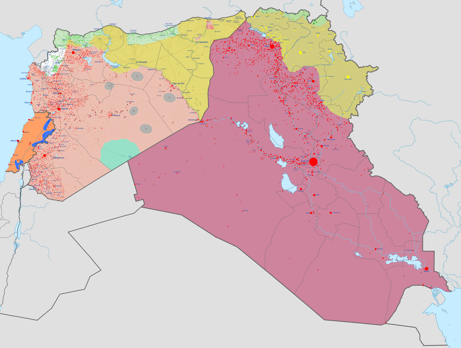
Map of the Syrian Civil War, the Iraq Civil War (2014–present), and the Lebanese insurgency. For previous revisions of the battle map (not including Lebanon) before June 2015, see File:Syria and Iraq 2014-onward War map.png. After updating this map, please also update the date(s) at w:Module:Iraq Syria map date, used to denote the date in articles. In the respective colours: |
| Date | |
| Source | Own work Derivate of Syrian Civil War map.svg by Ecrusized, Iraqi Civil War map (2014–present).svg by Clyde H. Mapping and Lebanese insurgency.svg by Oganesson007. |
| Author | Ecrusized |
| Other versions |
|
.svg)
.svg)

Licensing
[edit]
| This file is made available under the Creative Commons CC0 1.0 Universal Public Domain Dedication. | |
| The person who associated a work with this deed has dedicated the work to the public domain by waiving all of their rights to the work worldwide under copyright law, including all related and neighboring rights, to the extent allowed by law. You can copy, modify, distribute and perform the work, even for commercial purposes, all without asking permission.
|
File history
Click on a date/time to view the file as it appeared at that time.
| Date/Time | Thumbnail | Dimensions | User | Comment | |
|---|---|---|---|---|---|
| current | 23:42, 31 January 2024 | | 1,538 × 1,161 (4.83 MB) | Ecrusized (talk | contribs) | Fixes |
| 22:35, 31 January 2024 |  | 1,538 × 1,161 (4.85 MB) | Ecrusized (talk | contribs) | Fixes | |
| 22:12, 31 January 2024 |  | 1,538 × 1,161 (4.88 MB) | Ecrusized (talk | contribs) | Uploaded own work with UploadWizard |
You cannot overwrite this file.
File usage on Commons
The following 5 pages use this file:
File usage on other wikis
The following other wikis use this file:
- Usage on als.wikipedia.org
- Usage on am.wikipedia.org
- Usage on ar.wikipedia.org
- العراق
- تنظيم الدولة الإسلامية (داعش)
- تدخل حزب الله في الحرب الأهلية السورية
- التدخل الإيراني في العراق (2014–الآن)
- بوابة:تنظيم الدولة الإسلامية (داعش)/صورة مختارة/أرشيف
- بوابة:تنظيم الدولة الإسلامية (داعش)/صورة مختارة/1
- قائمة الحروب والمعارك التي تشمل تنظيم الدولة الإسلامية (داعش)
- تداعيات الحرب الأهلية السورية
- الخط الزمني للأحداث المتعلقة بداعش (2016)
- التدخل العسكري الدولي ضد تنظيم الدولة الإسلامية (داعش)
- Usage on arz.wikipedia.org
- Usage on ast.wikipedia.org
- Usage on azb.wikipedia.org
- Usage on bcl.wikipedia.org
- Usage on be-tarask.wikipedia.org
- Usage on be.wikipedia.org
- Usage on bg.wikipedia.org
- Usage on bn.wikipedia.org
- Usage on br.wikipedia.org
- Usage on ce.wikipedia.org
- Usage on cs.wikipedia.org
- Usage on cy.wikipedia.org
- Usage on da.wikipedia.org
- Usage on de.wikipedia.org
- Usage on de.wikinews.org
- Usage on diq.wikipedia.org
- Usage on el.wikipedia.org
- Usage on en.wikipedia.org
- Kurdistan
- Talk:List of ongoing armed conflicts
- Spillover of the Syrian civil war
- War against the Islamic State
- History of Iraq (2011–present)
- List of wars and battles involving the Islamic State
- Iranian intervention in Iraq (2014–present)
- Hezbollah involvement in the Syrian civil war
- Timeline of the War in Iraq (2014)
- Timeline of the Islamic State (2016)
- Rojava–Kurdistan Region relations
- Template:International military intervention against the Islamic State infobox
- Usage on es.wikipedia.org
- Usage on et.wikipedia.org
View more global usage of this file.
Metadata
- Maps of Islamic State of Iraq and the Levant
- Current civil wars maps
- Maps of the Syrian Civil War in 2018
- Maps of the Syrian Civil War in 2017
- Maps of the Syrian Civil War in 2016
- Maps of the Syrian Civil War in 2015
- Maps of the Iraqi Civil War (2014–2017)
- Maps of Lebanon
- Maps of Iraqi Kurdistan
- Maps of Syrian Kurdistan
- Conflicts in 2018
- Conflicts in 2017
- Conflicts in 2016
- Conflicts in 2015
- 2017 in Iraq
- 2016 in Iraq
- 2015 in Iraq
- 2017 in politics of Lebanon
- 2016 in Lebanon
- 2015 in Lebanon