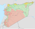
File:Syrian Civil War map (March 15 2013).svg

Original file (SVG file, nominally 922 × 762 pixels, file size: 18.22 MB)
Captions
Captions
Summary
[edit]| DescriptionSyrian Civil War map (March 15 2013).svg |
English: Detailed map of Syria showing the approximate frontlines during mid-March 2013; inspired by Ermanarich's work. All credit goes to Cedric Labrousse's work (https://twitter.com/syria_rebel_obs).
In the respective colours: |
|||||
| Date | ||||||
| Source | Own work | |||||
| Author | Rr016 | |||||
| SVG development InfoField | This oversized W3C-invalid icon was created with Inkscape. This icon uses embedded text that can be easily translated using a text editor.
|
Licensing
[edit]- You are free:
- to share – to copy, distribute and transmit the work
- to remix – to adapt the work
- Under the following conditions:
- attribution – You must give appropriate credit, provide a link to the license, and indicate if changes were made. You may do so in any reasonable manner, but not in any way that suggests the licensor endorses you or your use.
- share alike – If you remix, transform, or build upon the material, you must distribute your contributions under the same or compatible license as the original.
File history
Click on a date/time to view the file as it appeared at that time.
| Date/Time | Thumbnail | Dimensions | User | Comment | |
|---|---|---|---|---|---|
| current | 21:54, 30 August 2021 |  | 922 × 762 (18.22 MB) | Rr016 (talk | contribs) | Corrections to Hama and Homs frontlines |
| 15:12, 8 December 2020 |  | 922 × 762 (18.22 MB) | Rr016 (talk | contribs) | Corrections here and there | |
| 19:52, 19 March 2020 |  | 922 × 762 (18.76 MB) | Rr016 (talk | contribs) | Corrections to Damascus area | |
| 14:10, 2 March 2020 |  | 922 × 762 (18.76 MB) | Rr016 (talk | contribs) | Corrections to Deir ez Zor province | |
| 20:04, 11 January 2020 |  | 922 × 762 (18.75 MB) | Rr016 (talk | contribs) | More corrections to Daraa province | |
| 17:37, 24 December 2019 |  | 922 × 762 (18.75 MB) | Rr016 (talk | contribs) | Changes to Daraa and Quneitra frontlines | |
| 13:15, 12 September 2019 |  | 922 × 762 (18.75 MB) | Rr016 (talk | contribs) | Corrections made: 1) Dabaa airbase (Homs) was taken by rebels 18 April 2013 2) Zayta and Nazariyah (Homs) were always under SAA/Hezbollah control 3) Shirij (Hasakah) was seized by YPG mid-September 2013 | |
| 18:06, 20 August 2019 |  | 922 × 762 (18.74 MB) | Rr016 (talk | contribs) | Corrections made: 1) Khan Shaykhun (Idlib) was under siege until March 2014 2) Ayn Issa (Raqqa) was taken by rebels 30 March 2013 3) Tell Maaruf (Hasakah) was under YPG control since late February 2013 4) Thayyem Oil Field (Deir ez Zor) was under rebel control since late February 2013 | |
| 19:25, 19 July 2019 |  | 922 × 762 (18.29 MB) | Rr016 (talk | contribs) | Corrections made: 1) Jabal Turkman (Latakia) frontlines fixed 2) Qabtin & Junayd (Aleppo) were taken by rebels 14 March 2013 3) Sarrin (Aleppo) was not under YPG control yet | |
| 23:49, 21 June 2019 |  | 922 × 762 (18.29 MB) | Rr016 (talk | contribs) | Corrections made: 1) Namer (Daraa) was taken by SAA in May 2013 2) Tall Rusayn (Hasakah) was taken by YPG in November 2013 3) Qara and an-Nabek (Damascus) were taken by rebels in May/June 2013 |
You cannot overwrite this file.
File usage on Commons
The following 12 pages use this file:
- User:Magog the Ogre/Maps of conflicts/2019 August
- User:Magog the Ogre/Maps of conflicts/2019 December
- User:Magog the Ogre/Maps of conflicts/2019 July
- User:Magog the Ogre/Maps of conflicts/2019 June
- User:Magog the Ogre/Maps of conflicts/2019 May
- User:Magog the Ogre/Maps of conflicts/2019 September
- User:Magog the Ogre/Maps of conflicts/2020 December
- User:Magog the Ogre/Maps of conflicts/2020 January
- User:Magog the Ogre/Maps of conflicts/2020 March
- User:Magog the Ogre/Maps of conflicts/2021 August
- User:Rr016
- File:Syrian Civil War map (March 15 2013).svg
File usage on other wikis
The following other wikis use this file:
- Usage on bg.wikipedia.org
- Usage on bs.wikipedia.org
- Usage on en.wikipedia.org
- Usage on fa.wikipedia.org
- Usage on fr.wikipedia.org
- Usage on vi.wikipedia.org
Metadata
This file contains additional information such as Exif metadata which may have been added by the digital camera, scanner, or software program used to create or digitize it. If the file has been modified from its original state, some details such as the timestamp may not fully reflect those of the original file. The timestamp is only as accurate as the clock in the camera, and it may be completely wrong.
| Width | 921.83002 |
|---|---|
| Height | 761.91602 |
