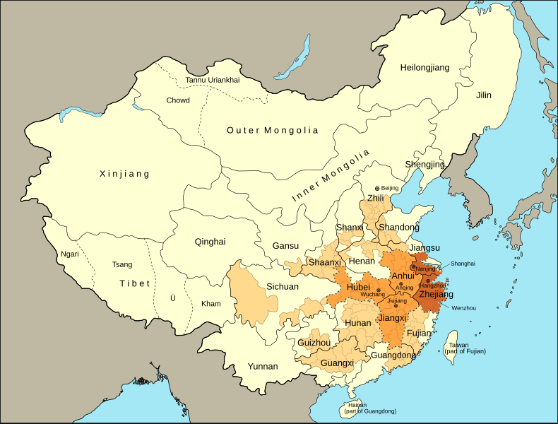
File:Taiping Heavenly Kingdom map.svg
From Wikimedia Commons, the free media repository
Jump to navigation
Jump to search

Size of this PNG preview of this SVG file: 790 × 600 pixels. Other resolutions: 316 × 240 pixels | 632 × 480 pixels | 1,012 × 768 pixels | 1,280 × 972 pixels | 2,560 × 1,944 pixels | 964 × 732 pixels.
Original file (SVG file, nominally 964 × 732 pixels, file size: 366 KB)
File information
Structured data
Captions
Captions
A map showing the extent of the Taiping Heavenly Kingdom
Summary
[edit]| DescriptionTaiping Heavenly Kingdom map.svg |
English: A map showing the extent of the Taiping Heavenly Kingdom
Outline of the Taiping Heavenly Kingdom
|
| Date | |
| Source |
Own work based on:
|
| Author | M.Bitton |
| Other versions |
|
Licensing
[edit]I, the copyright holder of this work, hereby publish it under the following license:
This file is licensed under the Creative Commons Attribution-Share Alike 4.0 International license.
- You are free:
- to share – to copy, distribute and transmit the work
- to remix – to adapt the work
- Under the following conditions:
- attribution – You must give appropriate credit, provide a link to the license, and indicate if changes were made. You may do so in any reasonable manner, but not in any way that suggests the licensor endorses you or your use.
- share alike – If you remix, transform, or build upon the material, you must distribute your contributions under the same or compatible license as the original.
File history
Click on a date/time to view the file as it appeared at that time.
| Date/Time | Thumbnail | Dimensions | User | Comment | |
|---|---|---|---|---|---|
| current | 21:28, 23 October 2022 |  | 964 × 732 (366 KB) | M.Bitton (talk | contribs) | Guandong → Guangdong |
| 20:18, 23 October 2022 |  | 964 × 732 (366 KB) | M.Bitton (talk | contribs) | more minor improvements | |
| 19:49, 23 October 2022 |  | 964 × 732 (366 KB) | M.Bitton (talk | contribs) | minor improvements | |
| 23:02, 18 September 2022 |  | 964 × 732 (366 KB) | M.Bitton (talk | contribs) | Corrected a spelling mistake and optimized the svg | |
| 13:15, 16 September 2022 |  | 964 × 732 (381 KB) | M.Bitton (talk | contribs) | Separated Shanghai and Wenzhu from the rest | |
| 15:58, 15 September 2022 |  | 964 × 732 (380 KB) | M.Bitton (talk | contribs) | removed all but the most important cities | |
| 14:17, 15 September 2022 |  | 964 × 732 (382 KB) | M.Bitton (talk | contribs) | Updated the map using a new source | |
| 19:33, 12 September 2022 |  | 964 × 732 (297 KB) | M.Bitton (talk | contribs) | Uploaded own work with UploadWizard |
You cannot overwrite this file.
File usage on Commons
The following 5 pages use this file:
File usage on other wikis
The following other wikis use this file:
- Usage on ar.wikipedia.org
- Usage on ast.wikipedia.org
- Usage on bg.wikipedia.org
- Usage on ca.wikipedia.org
- Usage on de.wikipedia.org
- Usage on en.wikipedia.org
- Usage on eo.wikiquote.org
- Usage on es.wikipedia.org
- Usage on et.wikipedia.org
- Usage on he.wikipedia.org
- Usage on it.wikipedia.org
- Usage on pt.wikipedia.org
- Usage on uk.wikipedia.org
- Usage on www.wikidata.org
- Usage on zh-yue.wikipedia.org
Metadata
This file contains additional information such as Exif metadata which may have been added by the digital camera, scanner, or software program used to create or digitize it. If the file has been modified from its original state, some details such as the timestamp may not fully reflect those of the original file. The timestamp is only as accurate as the clock in the camera, and it may be completely wrong.
| Width | 964.4 |
|---|---|
| Height | 732.03 |
Hidden categories:
