File:The World of 5 MHz.png
Jump to navigation
Jump to search
Size of this preview: 800 × 398 pixels. Other resolutions: 320 × 159 pixels | 640 × 318 pixels | 1,024 × 509 pixels | 1,280 × 637 pixels | 4,058 × 2,018 pixels.
Original file (4,058 × 2,018 pixels, file size: 1.09 MB, MIME type: image/png)
Captions
Captions
Add a one-line explanation of what this file represents
Summary
[edit]
| Description |
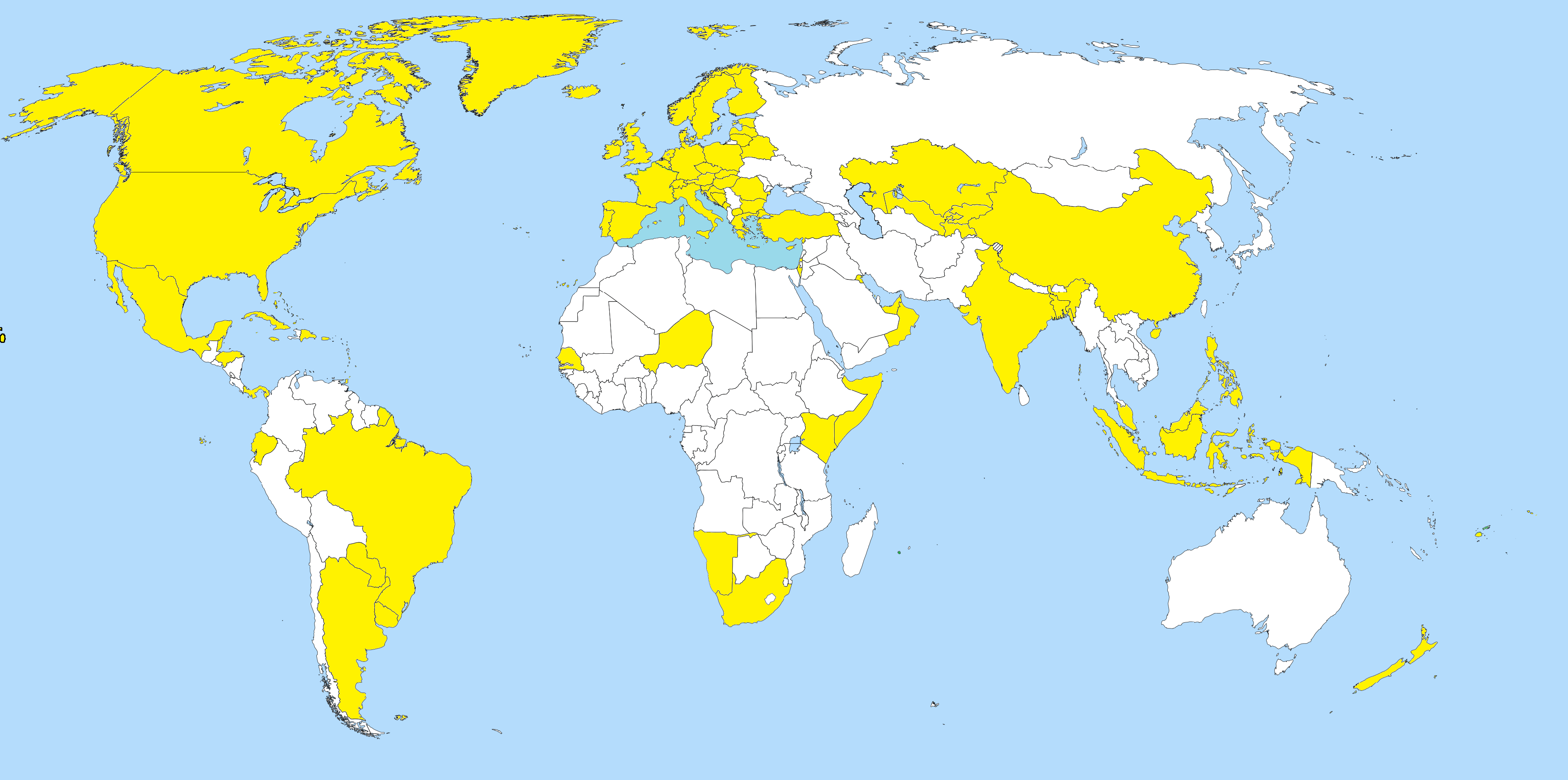
English: This map shows all the countries that currently have an official Amateur Radio presence on 5 MHz / 60m, whether it be by WRC-15, Article 4.4, Trial or any combination of these. |
| Date | |
| Source | From Wikimedia Commons File: A large blank world map with oceans marked in blue.svg |
| Author |
Petr Dlouhy (original) Paul Gaskell (yellow colouration) |

|
This file may be updated to reflect new information. If you wish to use a specific version of the file without it being overwritten, please upload the required version as a separate file. |

|
This map image could be re-created using vector graphics as an SVG file. This has several advantages; see Commons:Media for cleanup for more information. If an SVG form of this image is available, please upload it and afterwards replace this template with
{{vector version available|new image name}}.Note: Existing vector data is available from File:A large blank world map with oceans marked in blue.svg. It is recommended to name the SVG file “The World of 5 MHz.svg”—then the template Vector version available (or Vva) does not need the new image name parameter. |
Licensing
[edit]
| This file is made available under the Creative Commons CC0 1.0 Universal Public Domain Dedication. | |
| The person who associated a work with this deed has dedicated the work to the public domain by waiving all of their rights to the work worldwide under copyright law, including all related and neighboring rights, to the extent allowed by law. You can copy, modify, distribute and perform the work, even for commercial purposes, all without asking permission.
|
Any autoconfirmed user can overwrite this file from the same source. Please ensure that overwrites comply with the guideline.
File history
Click on a date/time to view the file as it appeared at that time.
| Date/Time | Thumbnail | Dimensions | User | Comment | |
|---|---|---|---|---|---|
| current | 23:42, 27 October 2021 | | 4,058 × 2,018 (1.09 MB) | Paul Gaskell (talk | contribs) | Green colour correction |
| 16:22, 21 October 2021 |  | 4,058 × 2,018 (1.09 MB) | Paul Gaskell (talk | contribs) | Added Malaysia - currently emcomm only (WRC-15 Allocation) | |
| 22:48, 7 June 2021 |  | 4,058 × 2,018 (1.09 MB) | Paul Gaskell (talk | contribs) | Reverted to version as of 00:21, 20 May 2021 (UTC) | |
| 07:40, 3 June 2021 |  | 4,058 × 2,018 (1.09 MB) | Paul Gaskell (talk | contribs) | Kyrgyzstan Correction | |
| 00:21, 20 May 2021 |  | 4,058 × 2,018 (1.09 MB) | Paul Gaskell (talk | contribs) | Reverted to version as of 09:54, 11 May 2021 (UTC) | |
| 12:49, 16 May 2021 |  | 4,058 × 2,018 (1.09 MB) | Paul Gaskell (talk | contribs) | offshore island | |
| 09:54, 11 May 2021 |  | 4,058 × 2,018 (1.09 MB) | Paul Gaskell (talk | contribs) | Added New Zealand (WRC-15 Allocation) | |
| 18:41, 2 January 2021 |  | 4,058 × 2,018 (1.09 MB) | Paul Gaskell (talk | contribs) | Added Uzbekistan and Tajikistan | |
| 06:57, 23 December 2020 |  | 4,096 × 2,033 (1.02 MB) | Paul Gaskell (talk | contribs) | Added Austria | |
| 00:44, 14 November 2020 |  | 4,096 × 2,033 (1.02 MB) | Paul Gaskell (talk | contribs) | Removed New Zealand |
You cannot overwrite this file.
File usage on Commons
The following 20 pages use this file:
- User:Chumwa/OgreBot/Potential transport maps/2019 November 21-30
- User:Chumwa/OgreBot/Travel and communication maps/2018 August 1-10
- User:Chumwa/OgreBot/Travel and communication maps/2018 December 1-10
- User:Chumwa/OgreBot/Travel and communication maps/2018 November 1-10
- User:Chumwa/OgreBot/Travel and communication maps/2018 November 11-20
- User:Chumwa/OgreBot/Travel and communication maps/2018 October 21-31
- User:Chumwa/OgreBot/Travel and communication maps/2018 September 1-10
- User:Chumwa/OgreBot/Travel and communication maps/2019 January 11-20
- User:Chumwa/OgreBot/Travel and communication maps/2019 June 1-10
- User:Chumwa/OgreBot/Travel and communication maps/2019 March 11-20
- User:Chumwa/OgreBot/Travel and communication maps/2019 November 21-30
- User:Chumwa/OgreBot/Travel and communication maps/2020 December 21-31
- User:Chumwa/OgreBot/Travel and communication maps/2020 February 10-19
- User:Chumwa/OgreBot/Travel and communication maps/2020 March 1-10
- User:Chumwa/OgreBot/Travel and communication maps/2020 March 21-31
- User:Chumwa/OgreBot/Travel and communication maps/2020 November 11-20
- User:Chumwa/OgreBot/Travel and communication maps/2021 January 1-10
- User:Chumwa/OgreBot/Travel and communication maps/2021 June 1-10
- User:Chumwa/OgreBot/Travel and communication maps/2021 October 21-31
- File:The World of 5 MHz Nov. 2019.png (file redirect)
File usage on other wikis
The following other wikis use this file:
- Usage on de.wikipedia.org
- Usage on en.wikipedia.org
- Usage on hu.wikipedia.org