File:Timezones2008-GE.png
Jump to navigation
Jump to search
Size of this preview: 800 × 413 pixels. Other resolutions: 320 × 165 pixels | 640 × 331 pixels | 1,024 × 529 pixels | 1,280 × 662 pixels | 3,558 × 1,839 pixels.
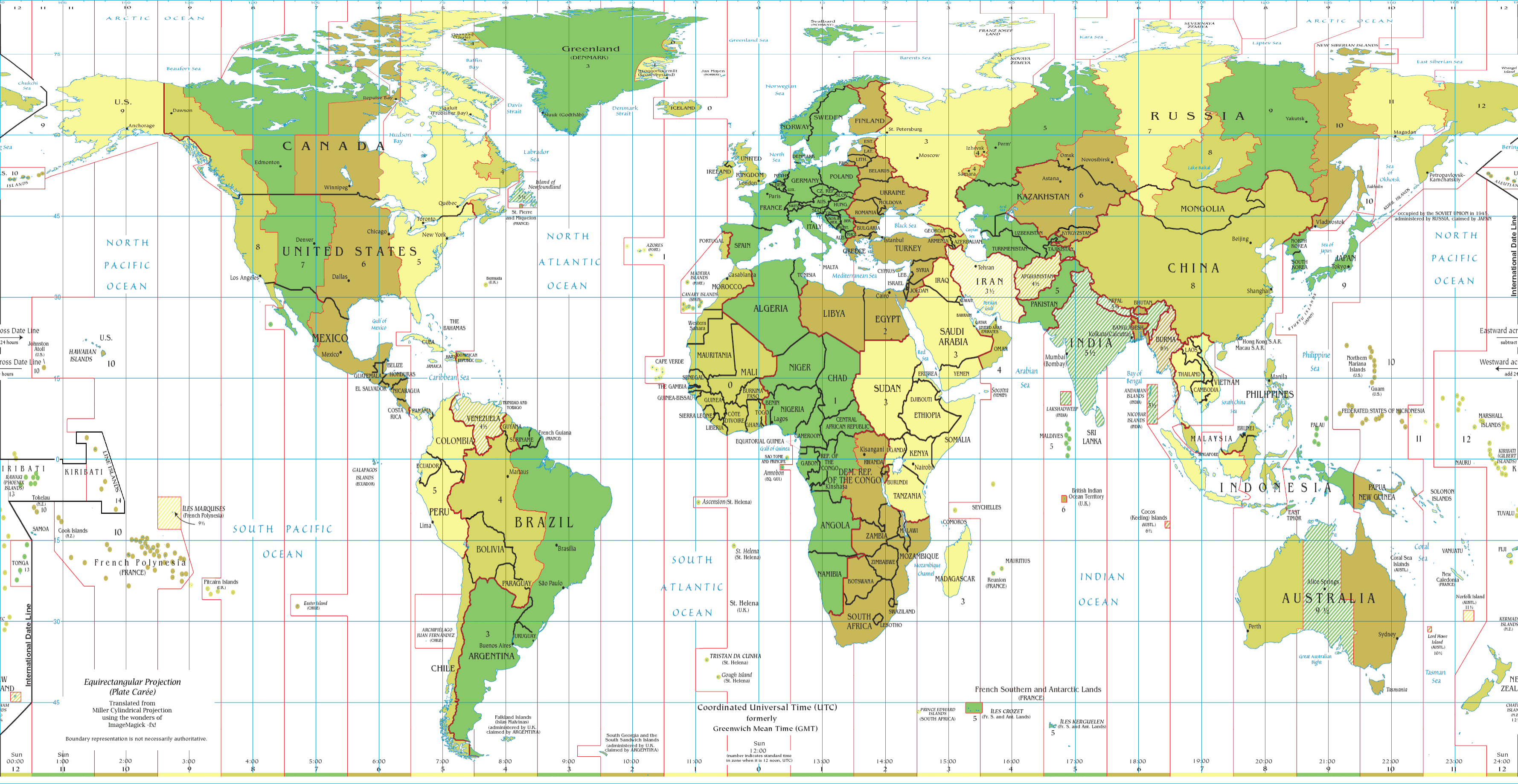
Original file (3,558 × 1,839 pixels, file size: 709 KB, MIME type: image/png)
Captions
Captions
Add a one-line explanation of what this file represents

|
This file has been superseded by World Time Zones Map.png. It is recommended to use the other file. Please note that deleting superseded images requires consent. Reason to use the other file: "The new image is more up-to-date including Time Zones changes."
|

|
| Description |
English: World map of time zones as of June 2008. Covers (exactly) latitude 85°N to 60°S, longitude 180°W to 180°E. Specially constructed to be usable as an accurate image overlay in Google Earth. |
| Date | (UTC) |
| Source | |
| Author |
|

|
This map image could be re-created using vector graphics as an SVG file. This has several advantages; see Commons:Media for cleanup for more information. If an SVG form of this image is available, please upload it and afterwards replace this template with
{{vector version available|new image name}}.
It is recommended to name the SVG file “Timezones2008-GE.svg”—then the template Vector version available (or Vva) does not need the new image name parameter. |
| This is a retouched picture, which means that it has been digitally altered from its original version. Modifications: Cropped; translated into Equirectangular projection for alignment with imagery in Google Earth.. The original can be viewed here: Timezones2008.png:
|
I, the copyright holder of this work, hereby publish it under the following license:
| |
This work has been released into the public domain by its author, Example, at the [[::|English Wikipedia]] project. This applies worldwide. In case this is not legally possible: |
Original upload log
[edit]
This image is a derivative work of the following images:
- Image:Timezones2008.png licensed with PD-user-w
- 2008-08-29T18:04:19Z File Upload Bot (Magnus Manske) 3583x1917 (1284684 Bytes) {{BotMoveToCommons|en.wikipedia}} {{Information |Description={{en|World map of time zones as of June 2008.}} |Source=Transferred from [http://en.wikipedia.org en.wikipedia]; transferred to Commons by [[User:Phatom87]] using
Uploaded with derivativeFX
File history
Click on a date/time to view the file as it appeared at that time.
| Date/Time | Thumbnail | Dimensions | User | Comment | |
|---|---|---|---|---|---|
| current | 00:00, 31 August 2008 | | 3,558 × 1,839 (709 KB) | Norville (talk | contribs) | {{Information |Description={{en|World map of time zones as of June 2008. Covers latitude 85°N to 60°S, longitude 180°W to 180°E. Specially modified to be usable as an accurate image overlay in Google Earth. |Source=*Image:Timezones2008.png |Da |
You cannot overwrite this file.
File usage on Commons
There are no pages that use this file.