File:Tokage 2016-11-26 0210Z.png
Jump to navigation
Jump to search

Size of this preview: 484 × 599 pixels. Other resolutions: 194 × 240 pixels | 388 × 480 pixels | 620 × 768 pixels | 827 × 1,024 pixels | 2,100 × 2,600 pixels.
Original file (2,100 × 2,600 pixels, file size: 11.58 MB, MIME type: image/png)
Captions
Captions
Add a one-line explanation of what this file represents
Summary
[edit]| Description |
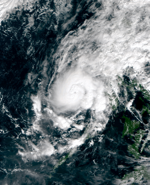
English: Tropical Storm Tokage south of Scarborough Shoal (Huangyan Dao) on November 26, 2016. |
| Date | |
| Source | RealEarth™ |
| Author | AHI image captured by the Japan Meteorology Agency’s Himawari-8 satellite |
| Camera location | | View this and other nearby images on: OpenStreetMap |
|---|
Licensing
[edit]This image was produced by the SSEC/CIMSS, University of Wisconsin–Madison. All the images published on their website can be freely used, as long as the source is acknowledged. (disclaimer (archive))
|
 |

File history
Click on a date/time to view the file as it appeared at that time.
| Date/Time | Thumbnail | Dimensions | User | Comment | |
|---|---|---|---|---|---|
| current | 18:25, 11 January 2023 | | 2,100 × 2,600 (11.58 MB) | TheWxResearcher (talk | contribs) | 500m resolution |
| 15:08, 26 November 2016 |  | 960 × 1,280 (2.22 MB) | Meow (talk | contribs) | User created page with UploadWizard |
You cannot overwrite this file.
File usage on Commons
The following page uses this file:
File usage on other wikis
The following other wikis use this file:
- Usage on en.wikipedia.org