File:Topographic map example.png
Jump to navigation
Jump to search
No higher resolution available.
Topographic_map_example.png (600 × 600 pixels, file size: 152 KB, MIME type: image/png)
Captions
Captions
Add a one-line explanation of what this file represents
Summary
[edit]
| Description |
Esperanto: La bildo estas kopiita de wikipedia:en. La originala priskribo estas:
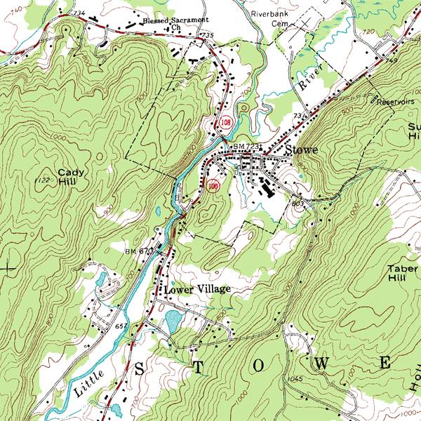
English: An inset from the USGS topographic map of Stowe, Vermont, USA, featuring 20-foot (6.096 m) contour intervals. The scale is 1:24,000.
עברית: מפה טופוגרפית באדיבות USGS.
במפה בולטים קוי הגובה (בצבע אדמדם) הנותנים תמונה תלת מימדית למי שיודע לפענח אותם. בהפרש של כל מאה מטרים, קו הגובה בולט ולידו כתוב מספרו. מצד שמאל ניתן לראות את גבעת קאדי שגובה פסגתה הוא 1122 מטר. במרכז המפה אפשר לראות נחל (בתכלת) שעובר בגיא, מכיוון צפון-מזרח לדרום-מערב. במרכז הגיא יש מאגר מים המסומן בתכלת. כמו כן ניתן לראות במפה רשת של כבישים (קו אדום לבן), ולידם בתים (קוביות שחורות). עוד במפה שבילים העולים אל הגבעות. (קוים שחורים מקווקוים). |
| Source | Sample taken from the public domain USGS Digital Raster Graphic file o44072d6.tif for the Stowe, VT quadrangle |
| Author | USGS |
Licensing
[edit]
This image is in the public domain in the United States because it only contains materials that originally came from the United States Geological Survey, an agency of the United States Department of the Interior. For more information, see the official USGS copyright policy.
|
Original upload log
[edit]
- 30 September 2005, 11:23 . . Riumplus (talk) . . 600x600 (155211 bytes) (Losslessly recompressed the image, shrinking file size by 5% (gAMA chunk preserved))
- 12 May 2004, 14:23 . . Redjar (talk) . . 600x600 (160792 bytes) (example of a topographic map)
| date/time | username | edit summary |
|---|---|---|
| 12 December 2005, 23:13 | Rcc105 | (adding name of quad) |
| 3 October 2004, 21:19 | BrokenSegue | (usgs) |
| 4 June 2004, 06:20 | Template namespace initialisation script | |
| 12 May 2004, 14:34 | Redjar | (added description and source information) |
| 12 May 2004, 14:23 | Redjar | (example of a topographic map) |
File history
Click on a date/time to view the file as it appeared at that time.
| Date/Time | Thumbnail | Dimensions | User | Comment | |
|---|---|---|---|---|---|
| current | 18:24, 18 March 2006 | | 600 × 600 (152 KB) | Maksim (talk | contribs) | La bildo estas kopiita de wikipedia:en. La originala priskribo estas: '''Description:''' Example of a topographic map with contour intervals '''Source:''' Sample taken from the public domain USGS Digital Raster Graphic file o44072d6.tif for the Stowe, V |
You cannot overwrite this file.
File usage on Commons
The following 6 pages use this file:
File usage on other wikis
The following other wikis use this file:
- Usage on af.wikipedia.org
- Usage on ar.wikipedia.org
- Usage on ast.wikipedia.org
- Usage on az.wikipedia.org
- Usage on be-tarask.wikipedia.org
- Usage on be.wikipedia.org
- Usage on bg.wikipedia.org
- Usage on bn.wikipedia.org
- Usage on bs.wikipedia.org
- Usage on ca.wikipedia.org
- Usage on ckb.wikipedia.org
- Usage on cs.wikipedia.org
- Usage on cy.wikipedia.org
- Usage on da.wikipedia.org
- Usage on de.wikipedia.org
- Usage on el.wikipedia.org
- Usage on en.wikipedia.org
View more global usage of this file.