File:Topographic map of Svalbard.svg

Original file (SVG file, nominally 2,497 × 2,537 pixels, file size: 1.56 MB)
Captions
Captions
Summary
[edit]| Description |
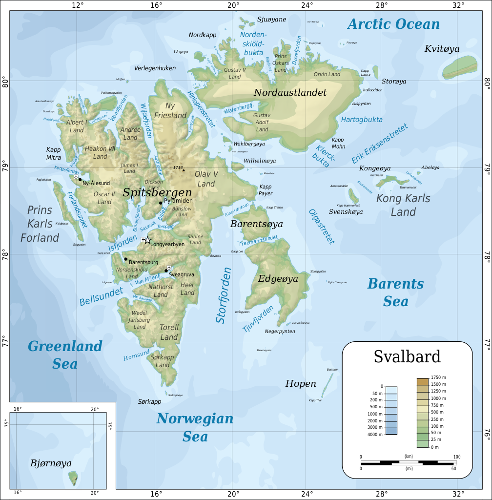
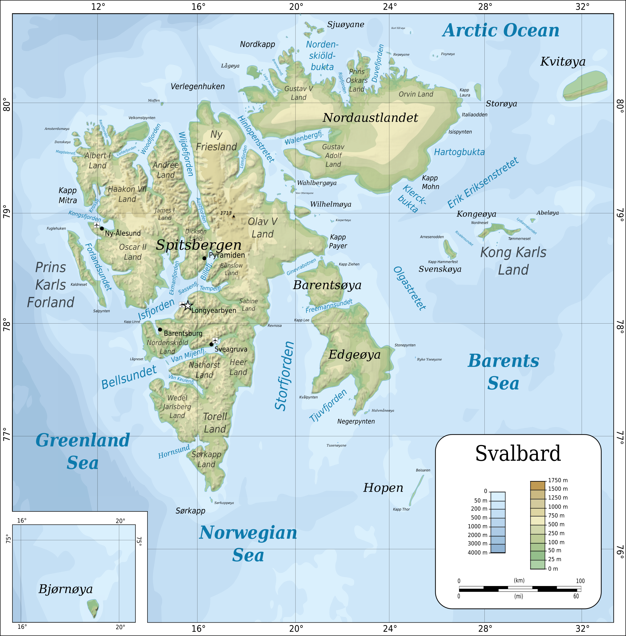
English: Topographic map of Svalbard.
Suomi: Huippuvuorten topografinen kartta.
日本語: スヴァールバル諸島の地形図。
Norsk bokmål: Topografisk kart over Svalbard.
Polski: Mapa topograficzna Svalbardu.
Русский: Топографическая_карта Шпицбергена.
Українська: Топографічна_карта Свальбарда. |
| Date | |
| Source |
Self-made in Inkscape by Mysid. |
| Author | Oona Räisänen (Mysid) |
| Other versions |
Derivative works of this file: Topographic map of Svalbard uk.svg
[]
|


|
This SVG file contains embedded text that can be translated into your language, using any capable SVG editor, text editor or the SVG Translate tool. For more information see: About translating SVG files. |
Licensing
[edit]

|
Permission is granted to copy, distribute and/or modify this document under the terms of the GNU Free Documentation License, Version 1.2 or any later version published by the Free Software Foundation; with no Invariant Sections, no Front-Cover Texts, and no Back-Cover Texts. A copy of the license is included in the section entitled GNU Free Documentation License. |
- You are free:
- to share – to copy, distribute and transmit the work
- to remix – to adapt the work
- Under the following conditions:
- attribution – You must give appropriate credit, provide a link to the license, and indicate if changes were made. You may do so in any reasonable manner, but not in any way that suggests the licensor endorses you or your use.
- share alike – If you remix, transform, or build upon the material, you must distribute your contributions under the same or compatible license as the original.
File history
Click on a date/time to view the file as it appeared at that time.
| Date/Time | Thumbnail | Dimensions | User | Comment | |
|---|---|---|---|---|---|
| current | 11:57, 11 December 2019 | | 2,497 × 2,537 (1.56 MB) | Omotecho (talk | contribs) | File uploaded using svgtranslate tool (https://tools.wmflabs.org/svgtranslate/). Added translation for ja. |
| 11:28, 11 December 2019 |  | 2,497 × 2,537 (1.55 MB) | Omotecho (talk | contribs) | File uploaded using svgtranslate tool (https://tools.wmflabs.org/svgtranslate/). Added translation for ja. | |
| 07:55, 6 September 2010 |  | 2,497 × 2,537 (1.39 MB) | Mysid (talk | contribs) | less opacity for the shading | |
| 07:51, 6 September 2010 |  | 2,497 × 2,537 (1.39 MB) | Mysid (talk | contribs) | fixed more spelling as per talk + revised the relief shading | |
| 10:49, 22 July 2010 |  | 2,497 × 2,537 (4.31 MB) | Mysid (talk | contribs) | fixed a plethora of spelling errors as pointed out in talk | |
| 13:24, 19 July 2010 |  | 2,497 × 2,537 (4.3 MB) | Mysid (talk | contribs) | further font cleanup | |
| 21:54, 22 June 2010 |  | 2,496 × 3,006 (4.25 MB) | Mysid (talk | contribs) | fonts | |
| 13:53, 22 June 2010 |  | 2,496 × 3,006 (4.23 MB) | Mysid (talk | contribs) | revised | |
| 18:27, 25 February 2008 |  | 2,400 × 2,898 (4.47 MB) | Mysid (talk | contribs) | shading | |
| 19:29, 16 February 2008 |  | 2,400 × 2,898 (1.29 MB) | Mysid (talk | contribs) | ok, works not. |
You cannot overwrite this file.
File usage on Commons
The following 9 pages use this file:
- Atlas of Svalbard
- Svalbard
- File:Topographic map of Svalbard.svg
- File:Topographic map of Svalbard de.svg
- File:Topographic map of Svalbard lv.svg
- File:Topographic map of Svalbard ru.svg
- File:Topographic map of Svalbard uk.svg
- File talk:Norway Svalbard location map.svg
- Template:Other versions/Topographic map of Svalbard
File usage on other wikis
The following other wikis use this file:
- Usage on af.wikipedia.org
- Usage on az.wikipedia.org
- Usage on be-tarask.wikipedia.org
- Usage on bg.wikipedia.org
- Usage on cy.wikipedia.org
- Usage on da.wikipedia.org
- Usage on de.wikipedia.org
- Usage on de.wikivoyage.org
- Usage on diq.wikipedia.org
- Usage on el.wikipedia.org
- Usage on en.wikipedia.org
- Usage on en.wikisource.org
- Usage on en.wikivoyage.org
- Usage on en.wiktionary.org
- Usage on es.wikipedia.org
- Usage on fa.wikipedia.org
- Usage on fi.wikipedia.org
- Usage on fr.wikipedia.org
- Usage on gl.wikipedia.org
- Usage on he.wikipedia.org
- Usage on he.wikivoyage.org
- Usage on hi.wikipedia.org
View more global usage of this file.