File:US Bank footprint 2010-01.png
Jump to navigation
Jump to search

Size of this preview: 800 × 410 pixels. Other resolutions: 320 × 164 pixels | 640 × 328 pixels | 1,024 × 524 pixels | 1,832 × 938 pixels.
Original file (1,832 × 938 pixels, file size: 321 KB, MIME type: image/png)
Captions
Captions
Add a one-line explanation of what this file represents
Summary
[edit]
| Description |
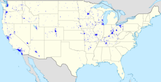
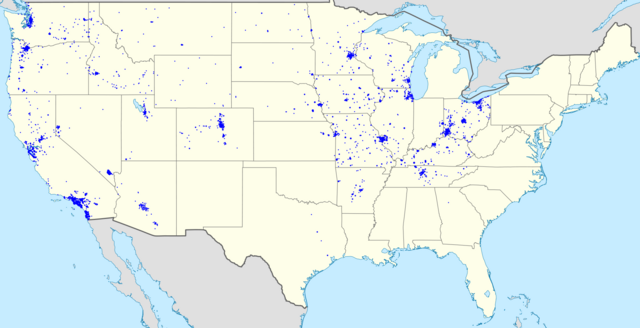
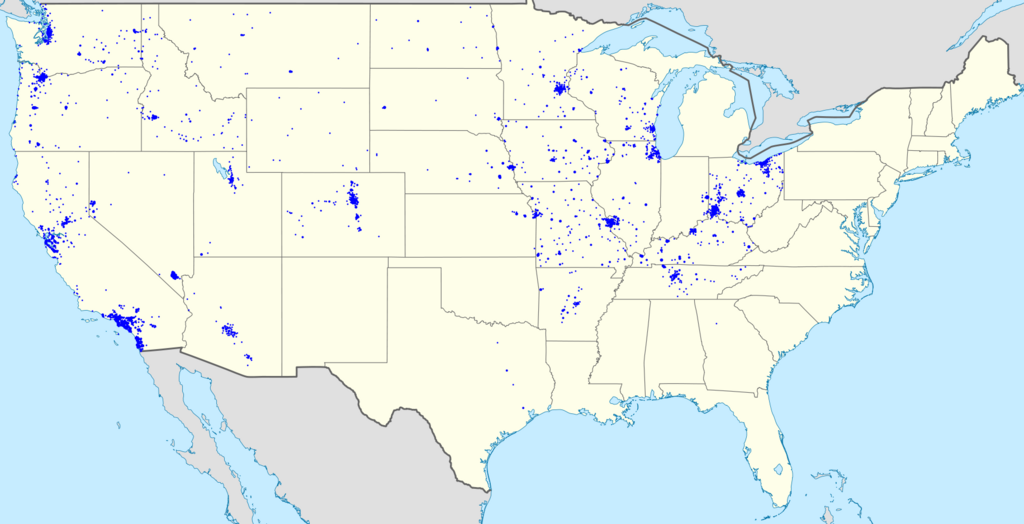
English: Footprint of U.S. Bancorp. Cities with more than one branch have progressively larger points. |
| Date | (UTC) |
| Source |
This file was derived from: USA location map.svg:
|
| Author |
|
| Other versions |
 |
| Point Maps
══▻ FAQ ◅══ ══▻ Create your own ◅══ |
Licensing
[edit]
I, the copyright holder of this work, hereby publish it under the following licenses:

|
Permission is granted to copy, distribute and/or modify this document under the terms of the GNU Free Documentation License, Version 1.2 or any later version published by the Free Software Foundation; with no Invariant Sections, no Front-Cover Texts, and no Back-Cover Texts. A copy of the license is included in the section entitled GNU Free Documentation License. |
This file is licensed under the Creative Commons Attribution-Share Alike 3.0 Unported license.
- You are free:
- to share – to copy, distribute and transmit the work
- to remix – to adapt the work
- Under the following conditions:
- attribution – You must give appropriate credit, provide a link to the license, and indicate if changes were made. You may do so in any reasonable manner, but not in any way that suggests the licensor endorses you or your use.
- share alike – If you remix, transform, or build upon the material, you must distribute your contributions under the same or compatible license as the original.
You may select the license of your choice.
Original upload log
[edit]
The original description page was here. All following user names refer to en.wikipedia.
- 2010-01-05 21:44 Magog the Ogre 1832×938× (329105 bytes) recrop
- 2010-01-05 21:40 Magog the Ogre 1623×950× (305197 bytes) {{Information |Description=Footprint of [[Hungtindon Bank]]. Cities with more than one branch have progressively larger points. |Source=I created this work entirely by myself; derived form [[:File:USA location map.svg]]. |Date=~~~~~ |Author=[[User:Magog t
This image is a derivative work of the following images:
- File:USA location map.svg licensed with Cc-by-sa-3.0, GFDL
- 2008-07-29T20:04:42Z NordNordWest 1859x968 (738148 Bytes) {{Information |Description= {{de|Positionskarte der [[:de:Vereinigte Staaten|Vereinigten Staaten]]}} Quadratische Plattkarte, N-S-Streckung 120 %. Geographische Begrenzung der Karte: * N: 49.8° N * S: 24.2° N * W: 125.5° W
Page texted generated with derivativeFX
File history
Click on a date/time to view the file as it appeared at that time.
| Date/Time | Thumbnail | Dimensions | User | Comment | |
|---|---|---|---|---|---|
| current | 18:40, 9 March 2013 | | 1,832 × 938 (321 KB) | OgreBot (talk | contribs) | (BOT): Uploading old version of file from en.wikipedia; originally uploaded on 2010-01-05 21:44:30 by Magog the Ogre |
| 18:40, 9 March 2013 |  | 1,623 × 950 (298 KB) | OgreBot (talk | contribs) | (BOT): Uploading old version of file from en.wikipedia; originally uploaded on 2010-01-05 21:40:06 by Magog the Ogre |
You cannot overwrite this file.
File usage on Commons
The following 2 pages use this file:
- File:USBankfootprint.png (file redirect)
- File:US Bank footprint 2013-03.png