File:Venezia Giulia province.png
Jump to navigation
Jump to search

Size of this preview: 291 × 598 pixels. Other resolutions: 117 × 240 pixels | 233 × 480 pixels | 373 × 768 pixels | 498 × 1,024 pixels | 1,930 × 3,967 pixels.
Original file (1,930 × 3,967 pixels, file size: 414 KB, MIME type: image/png)
Captions
Captions
Add a one-line explanation of what this file represents

|
File:Provinces of Venezia Giulia (1923-1947).svg is a vector version of this file. It should be used in place of this PNG file when not inferior.
File:Venezia Giulia province.png → File:Provinces of Venezia Giulia (1923-1947).svg
For more information, see Help:SVG. |
.svg) |
Summary
[edit]
| Description |
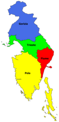
Italiano: Province della Venezia Giulia nel periodo che intercorre dal 1923 al 1947, elencate dall'alto verso il basso: Gorizia, Trieste, Fiume, Pola. Non viene riportata la provincia di Zara. English: Provinces of Venezia Giulia in the 1923 -1947 period: Gorizia, Trieste, Fiume, Pola. Zara's one isn't depicted. |
| Date | |
| Source | Own work |
| Author | Karplus |
Licensing
[edit]
I, the copyright holder of this work, hereby publish it under the following license:
This file is licensed under the Creative Commons Attribution-Share Alike 3.0 Unported license.
- You are free:
- to share – to copy, distribute and transmit the work
- to remix – to adapt the work
- Under the following conditions:
- attribution – You must give appropriate credit, provide a link to the license, and indicate if changes were made. You may do so in any reasonable manner, but not in any way that suggests the licensor endorses you or your use.
- share alike – If you remix, transform, or build upon the material, you must distribute your contributions under the same or compatible license as the original.
File history
Click on a date/time to view the file as it appeared at that time.
| Date/Time | Thumbnail | Dimensions | User | Comment | |
|---|---|---|---|---|---|
| current | 10:28, 16 June 2022 | | 1,930 × 3,967 (414 KB) | Karplus (talk | contribs) | fixed lower eastern border, according to italian administrative levels of 1924 |
| 21:12, 14 June 2022 |  | 2,793 × 5,881 (658 KB) | Karplus (talk | contribs) | fixed part of eastern border, added name of former italian administrative levels and resolution increased | |
| 18:47, 24 April 2013 |  | 1,837 × 3,234 (296 KB) | Karplus (talk | contribs) | il comune di Capodistria ora é correttamente assegnato alla provincia di Pola | |
| 21:18, 14 April 2013 |  | 1,941 × 3,410 (321 KB) | Karplus (talk | contribs) | User created page with UploadWizard |
You cannot overwrite this file.
File usage on Commons
The following 2 pages use this file:
File usage on other wikis
The following other wikis use this file:
- Usage on sr.wikipedia.org