File:Venezuela Division Politica Territorial.svg
Jump to navigation
Jump to search

Size of this PNG preview of this SVG file: 781 × 600 pixels. Other resolutions: 313 × 240 pixels | 625 × 480 pixels | 1,000 × 768 pixels | 1,280 × 983 pixels | 2,560 × 1,966 pixels | 2,121 × 1,629 pixels.
Original file (SVG file, nominally 2,121 × 1,629 pixels, file size: 141 KB)
Captions
Captions
Add a one-line explanation of what this file represents
| Description |
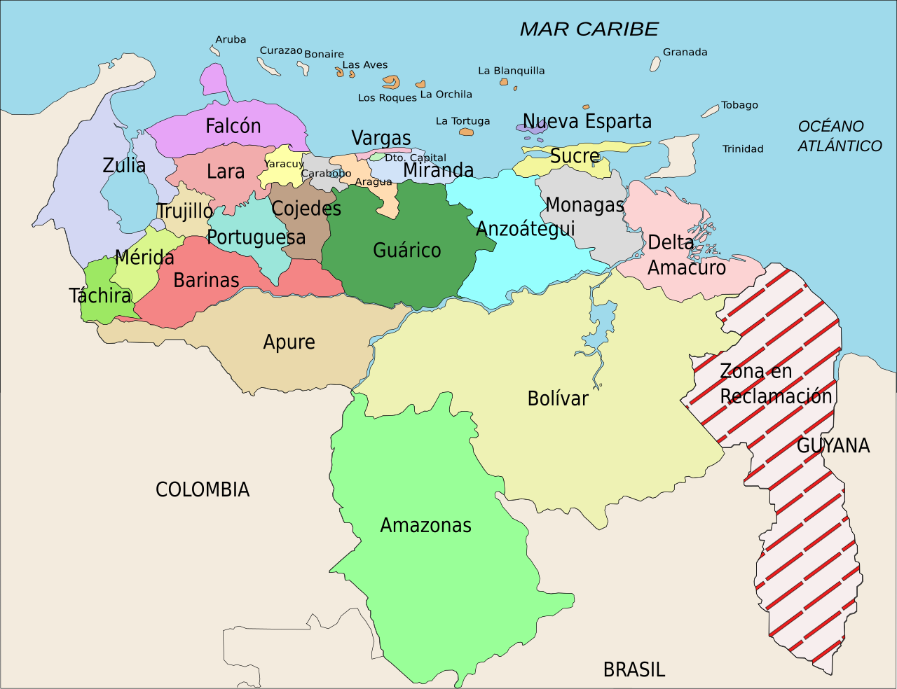
Español: División Político Territorial de Venezuela. Es un mapa acerca de los estados de Venezuela o división político territorial. La zona en reclamación aun no se sabe si pertenece a Guyana o a Venezuela, por eso se suele colocar de esa manera.
English: Political divisions of Venezuela. The Reclamation zone is Guyanan territory claimed by Venezuela. |
| Date | |
| Source | self work, Image:Venezuela politica copy.png based |
| Author | Wilfredor |
| Permission (Reusing this file) |
Own work, copyleft: Multi-license with GFDL and Creative Commons CC-BY-SA-2.5 and older versions (2.0 and 1.0) |
| Other versions |
Derivative works of this file: Venezuela Division Politica Territorial mk.svg
[]
|


This W3C-unspecified vector image was created with Inkscape .
I, the copyright holder of this work, hereby publish it under the following licenses:

|
Permission is granted to copy, distribute and/or modify this document under the terms of the GNU Free Documentation License, Version 1.2 or any later version published by the Free Software Foundation; with no Invariant Sections, no Front-Cover Texts, and no Back-Cover Texts. A copy of the license is included in the section entitled GNU Free Documentation License. |
| This file is licensed under the Creative Commons Attribution-Share Alike 3.0 Unported license. | ||
| ||
| This licensing tag was added to this file as part of the GFDL licensing update. |
This file is licensed under the Creative Commons Attribution-Share Alike 2.5 Generic, 2.0 Generic and 1.0 Generic license.
- You are free:
- to share – to copy, distribute and transmit the work
- to remix – to adapt the work
- Under the following conditions:
- attribution – You must give appropriate credit, provide a link to the license, and indicate if changes were made. You may do so in any reasonable manner, but not in any way that suggests the licensor endorses you or your use.
- share alike – If you remix, transform, or build upon the material, you must distribute your contributions under the same or compatible license as the original.
You may select the license of your choice.
File history
Click on a date/time to view the file as it appeared at that time.
| Date/Time | Thumbnail | Dimensions | User | Comment | |
|---|---|---|---|---|---|
| current | 21:00, 16 April 2008 | | 2,121 × 1,629 (141 KB) | Wilfredor (talk | contribs) | {{Information |Description= '''(Spanish):''' División Político Territorial de Venezuela. Es un mapa acerca de los estados de Venezuela o división político territorial. La zona en reclamación aun no se sabe si pertenece a Guyana o a Venezuela, por es |
| 15:17, 21 April 2007 |  | 2,121 × 1,629 (140 KB) | Wilfredor (talk | contribs) | {{Information |Description= '''(Spanish):''' División Político Territorial de Venezuela. Es un mapa acerca de los estados de Venezuela o división político territorial. La zona en reclamación aun no se sabe si pertenece a Guyana o a Venezuela, por es | |
| 21:11, 19 April 2007 |  | 2,121 × 1,629 (135 KB) | Spundun (talk | contribs) | Reverted to earlier revision | |
| 21:10, 19 April 2007 |  | 2,119 × 1,629 (135 KB) | Spundun (talk | contribs) | Reverted to earlier revision | |
| 14:52, 19 April 2007 |  | 2,121 × 1,629 (135 KB) | Wilfredor (talk | contribs) | {{Information |Description= '''(Spanish):''' División Político Territorial de Venezuela </br> '''(English):''' Politic Territorial Division of Venezuela |Source=self work, Image:Venezuela politica copy.png based |Date=2007 |Author=[[user:wilfredo | |
| 00:33, 18 April 2007 |  | 2,119 × 1,629 (135 KB) | Wilfredor (talk | contribs) | {{Information |Description= '''(Spanish):''' División Político Territorial de Venezuela </br> '''(English):''' Politic Territorial Division of Venezuela |Source=self work |Date=2007 |Author=Wilfredo R. Rodriguez H. |Permission=Own wo | |
| 23:55, 17 April 2007 |  | 2,119 × 1,629 (124 KB) | Wilfredor (talk | contribs) | {{Information |Description= '''(Spanish):''' División Político Territorial de Venezuela </br> '''(English):''' Politic Territorial Division of Venezuela |Source=self work |Date=2007 |Author=Wilfredo R. Rodriguez H. |Permission=Own wo | |
| 20:56, 17 April 2007 |  | 2,160 × 1,664 (107 KB) | Wilfredor (talk | contribs) | {{Information |Description= '''(Spanish):''' División Político Territorial de Venezuela </br> '''(English):''' Politic Territorial Division of Venezuela |Source=self work |Date=2007 |Author=Wilfredo R. Rodriguez H. |Permission=Own wo | |
| 13:30, 17 April 2007 |  | 2,160 × 1,664 (88 KB) | Wilfredor (talk | contribs) | {{Information |Description= '''(Spanish):''' División Político Territorial de Venezuela </br> '''(English):''' Politic Territorial Division of Venezuela |Source=self work |Date=2007 |Author=Wilfredo R. Rodriguez H. |Permission=Own wo | |
| 02:54, 17 April 2007 |  | 2,160 × 1,664 (83 KB) | Wilfredor (talk | contribs) | {{Information |Description= '''(Spanish):''' División Político Territorial de Venezuela </br> '''(English):''' Politic Territorial Division of Venezuela |Source=self work |Date=2007 |Author=Wilfredo R. Rodriguez H. |Permission=Own wo |
You cannot overwrite this file.
File usage on Commons
The following 10 pages use this file:
- Atlas of Venezuela
- Commons:Featured picture candidates/Image:Venezuela Division Politica Territorial.svg
- Commons:Featured picture candidates/Log/April 2007
- Commons:Quality images candidates/Archives April 2007
- File:Venezuela Division Politica Territorial.svg
- File:Venezuela Division Politica Territorial ka.svg
- File:Venezuela Division Politica Territorial mk.svg
- File:Venezuela politica copy.png
- Template:Other versions/Venezuela Division Politica Territorial
- Category:Relations of Guyana and Venezuela
File usage on other wikis
The following other wikis use this file:
- Usage on an.wikipedia.org
- Usage on be.wikipedia.org
- Usage on br.wikipedia.org
- Usage on bs.wikipedia.org
- Usage on cs.wikipedia.org
- Usage on da.wikipedia.org
- Usage on de.wikipedia.org
- Usage on en.wikipedia.org
- Usage on es.wikipedia.org
- Categoría:Estados de Venezuela
- Wikiproyecto Discusión:Venezuela/1
- Categoría:Municipios de Venezuela
- Usuario:Dezulovic
- Anexo:Gobernadores de Venezuela
- Agua potable y saneamiento en Venezuela
- Categoría:Geografía de Venezuela por estado
- Categoría:Localidades de Venezuela por estado
- Wikiproyecto:Relaciones bilaterales/creados
- Usage on es.wikibooks.org
- Usage on es.wikinews.org
- Usage on fiu-vro.wikipedia.org
- Usage on fi.wikipedia.org
- Usage on frr.wikipedia.org
- Usage on fr.wikipedia.org
- Projet:Géographie/Palettes de navigation
- Modèle:Palette États du Venezuela
- États du Venezuela
- État de Bolívar
- État de La Guaira
- État de Táchira
- État de Lara
- État de Falcón
- État d'Yaracuy
- État de Carabobo
- État de Zulia
- État de Portuguesa
- État de Trujillo
- État de Cojedes
- État d'Aragua
- État d'Amazonas (Venezuela)
- État de Guárico
View more global usage of this file.