File:VitoshaPlateau-1.jpg
Jump to navigation
Jump to search

Size of this preview: 800 × 531 pixels. Other resolutions: 320 × 213 pixels | 640 × 425 pixels | 1,024 × 680 pixels | 1,280 × 850 pixels | 2,560 × 1,700 pixels | 3,162 × 2,100 pixels.
Original file (3,162 × 2,100 pixels, file size: 3.71 MB, MIME type: image/jpeg)
Captions
Captions
Add a one-line explanation of what this file represents
This photograph was taken with a Nikon D90
Summary
[edit]
| Description |
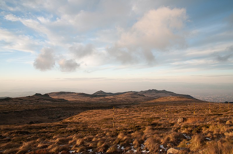
English: „Torfeno Branishte“ (Turf Reserve), the natural reserve on Vitosha Mountain, Bulgaria with the peak of „Ushite“ (1906 m) in the background and „Lavcheto peak“ (2053 m) in the closer left. The reserve spreads at average altitude of almost 2000 metres. The city of Sofia is visible in the far right background.
Български: Природният резерват „Торфено бранище“ на Витошкото плато, с връх „Ушите“ (1906 m) в дъното и връх „Лъвчето“ (2053 m) близко ляво. Резерватът се простира на средна надморска височина от почти 2000 метра. Град София се вижда в дъното в дясно. |
| Date | |
| Source | Own work |
| Author | MrPanyGoff |
| Camera location | | View this and other nearby images on: OpenStreetMap |
|---|
Licensing
[edit]
 |
This illustration was made by MrPanyGoff
Please credit this : © Plamen Agov • studiolemontree in the immediate vicinity of the image. If you use some of my photos, an email to
Do not copy this image illegally by ignoring the terms of the license below, as it is not in the public domain. |
Plamen Agov • studiolemontree, the copyright holder of this work, hereby publishes it under the following licenses:
This file is licensed under the Creative Commons Attribution-Share Alike 3.0 Unported license.
Attribution: Plamen Agov • studiolemontree
- You are free:
- to share – to copy, distribute and transmit the work
- to remix – to adapt the work
- Under the following conditions:
- attribution – You must give appropriate credit, provide a link to the license, and indicate if changes were made. You may do so in any reasonable manner, but not in any way that suggests the licensor endorses you or your use.
- share alike – If you remix, transform, or build upon the material, you must distribute your contributions under the same or compatible license as the original.

|
Permission is granted to copy, distribute and/or modify this document under the terms of the GNU Free Documentation License, Version 1.2 or any later version published by the Free Software Foundation; with no Invariant Sections, no Front-Cover Texts, and no Back-Cover Texts. A copy of the license is included in the section entitled GNU Free Documentation License. |
You may select the license of your choice.
| Annotations | This image is annotated: View the annotations at Commons |
This image has been assessed using the Quality image guidelines and is considered a Quality image.
|
File history
Click on a date/time to view the file as it appeared at that time.
| Date/Time | Thumbnail | Dimensions | User | Comment | |
|---|---|---|---|---|---|
| current | 16:34, 22 November 2010 | | 3,162 × 2,100 (3.71 MB) | MrPanyGoff (talk | contribs) | {{Information |Description={{en|1=en:Torfeno Branishte (Turf Reserve), the natural reserve on en:Vitosha Mountain, Bulgaria with the peak of “Ushite” (1906 m) in the background and “Lavcheto peak” (2053 m) in the closer left. The reserve s |
You cannot overwrite this file.
File usage on Commons
The following 7 pages use this file:
- User:MrPanyGoff/Places/Bulgaria/Sofia
- User talk:MrPanyGoff/Archive
- Commons:Featured picture candidates/File:VitoshaPlateau-1.jpg
- Commons:Featured picture candidates/Log/December 2010
- Commons:Quality images/Subject/Places/Natural structures/archive 2008 to 2012
- Commons:Quality images candidates/Archives November 2010
- File:VitoshaPlateau-1.jpg
File usage on other wikis
The following other wikis use this file:
- Usage on az.wikipedia.org
- Usage on en.wikipedia.org
- Usage on fr.wikipedia.org
- Usage on ja.wikipedia.org
- Usage on sq.wikipedia.org
- Usage on sr.wikipedia.org
- Usage on tr.wikipedia.org
- Usage on uk.wikipedia.org