File:Vrstevnice.png
Jump to navigation
Jump to search
No higher resolution available.
Vrstevnice.png (177 × 144 pixels, file size: 11 KB, MIME type: image/png)
Captions
Captions
Add a one-line explanation of what this file represents
Summary
[edit]
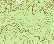
| Description |
English: contour lines
Čeština: vrstevnice |
| Date | (UTC) |
| Source | |
| Author |
|
| This is a retouched picture, which means that it has been digitally altered from its original version. Modifications: croped for another use. The original can be viewed here: Topographic map example.png:
|
Licensing
[edit]
| I, the copyright holder of this work, release this work into the public domain. This applies worldwide. In some countries this may not be legally possible; if so: I grant anyone the right to use this work for any purpose, without any conditions, unless such conditions are required by law. |
Original upload log
[edit]
This image is a derivative work of the following images:
- File:Topographic_map_example.png licensed with PD-USGov-USGS
- 2006-03-18T18:24:02Z Maksim 600x600 (155211 Bytes) La bildo estas kopiita de wikipedia:en. La originala priskribo estas: '''Description:''' Example of a topographic map with contour intervals '''Source:''' Sample taken from the public domain USGS Digital Raster Graphic file
Uploaded with derivativeFX
File history
Click on a date/time to view the file as it appeared at that time.
| Date/Time | Thumbnail | Dimensions | User | Comment | |
|---|---|---|---|---|---|
| current | 12:36, 11 June 2009 | | 177 × 144 (11 KB) | Palu (talk | contribs) | {{Information |Description={{en|contour lines}} {{cs|vrstevnice}} |Source=*File:Topographic_map_example.png |Date=2009-06-11 13:33 (UTC) |Author=*File:Topographic_map_example.png: USGS *derivative work: ~~~ |Permission=see below |other_version |
You cannot overwrite this file.
File usage on Commons
There are no pages that use this file.
File usage on other wikis
The following other wikis use this file:
- Usage on de.wikipedia.org