File:WWII Europe 1941-1942 Map EN.png
Jump to navigation
Jump to search
Size of this preview: 654 × 600 pixels. Other resolutions: 262 × 240 pixels | 523 × 480 pixels | 837 × 768 pixels | 1,090 × 1,000 pixels.
Original file (1,090 × 1,000 pixels, file size: 99 KB, MIME type: image/png)
Captions
Captions
Add a one-line explanation of what this file represents

|
This military map image could be re-created using vector graphics as an SVG file. This has several advantages; see Commons:Media for cleanup for more information. If an SVG form of this image is available, please upload it and afterwards replace this template with
{{vector version available|new image name}}.
It is recommended to name the SVG file “WWII Europe 1941-1942 Map EN.svg”—then the template Vector version available (or Vva) does not need the new image name parameter. |
Summary
[edit]Ελληνικά: Εδαφικές κατακτήσεις του Ράιχ
Español: Conquistas territoriales del Reich
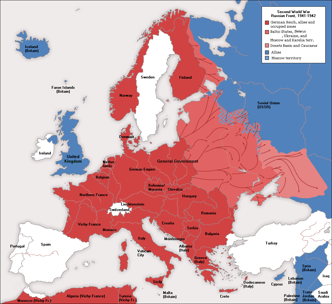
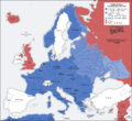
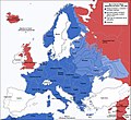
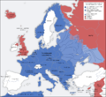
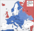
A map of German front of the Second World War circa 1941-1942. The original German-language map was created by User:San Jose on 17 April 2005. It can be found here.
This image is a translation of the original, created and released under the terms of the GNU Free Documentation License. It was created and uploaded by User:ArmadniGeneral on 22 December 2005.
| This is a retouched picture, which means that it has been digitally altered from its original version. Modifications: altered colors to reflect other map color schemes on the wiki page Nazi_Germany. The original can be viewed here: Second world war europe 1941-1942 map en.png:
|
[]
-
 Deutsch
 -
 English
 -
 English (alt)
 -
 polski
 -
 українська
 -
 հայերեն
 -
 中文(简体)
 -
 中文(繁體)


_en.png)
.png)
.jpg)
Licensing
[edit]

|
Permission is granted to copy, distribute and/or modify this document under the terms of the GNU Free Documentation License, Version 1.2 or any later version published by the Free Software Foundation; with no Invariant Sections, no Front-Cover Texts, and no Back-Cover Texts. A copy of the license is included in the section entitled GNU Free Documentation License. |
| This file is licensed under the Creative Commons Attribution-Share Alike 3.0 Unported license. | ||
| ||
| This licensing tag was added to this file as part of the GFDL licensing update. |
File history
Click on a date/time to view the file as it appeared at that time.
| Date/Time | Thumbnail | Dimensions | User | Comment | |
|---|---|---|---|---|---|
| current | 09:37, 23 September 2009 | | 1,090 × 1,000 (99 KB) | Ianjameslyon (talk | contribs) | == Summary == {{SVG|map}} {{el|Εδαφικές κατακτήσεις του Ράιχ}} {{es|Conquistas territoriales del Reich}} A map of German front of the Second World War circa 1941-1942. The original German-language map was created by [[User:San Jo |
You cannot overwrite this file.
File usage on Commons
The following 9 pages use this file:
- File:1941年到1942年二戰歐洲戰場局勢.png
- File:2svitovavijnamapa.jpg
- File:Second world war europe 1941-1942 map de.png
- File:Second world war europe 1941-1942 map en.png
- File:Second world war europe 1941-1942 map hy.png
- File:Second world war europe 1941-1942 map pl.png
- File:WWII Europe 1941-1942 Map EN.png
- File:欧洲局势 1941-1942.png
- Template:Other versions/World War II in Europe, 1941-1942
File usage on other wikis
The following other wikis use this file:
- Usage on cs.wikipedia.org
- Usage on pt.wikipedia.org
- Usage on rm.wikipedia.org