File:Weihnachtsflut61.jpg
Jump to navigation
Jump to search
Size of this preview: 702 × 600 pixels. Other resolutions: 281 × 240 pixels | 562 × 480 pixels | 899 × 768 pixels | 1,199 × 1,024 pixels | 2,048 × 1,749 pixels.
Original file (2,048 × 1,749 pixels, file size: 2.46 MB, MIME type: image/jpeg)
Captions
Captions
Add a one-line explanation of what this file represents
Summary
[edit]| Description |
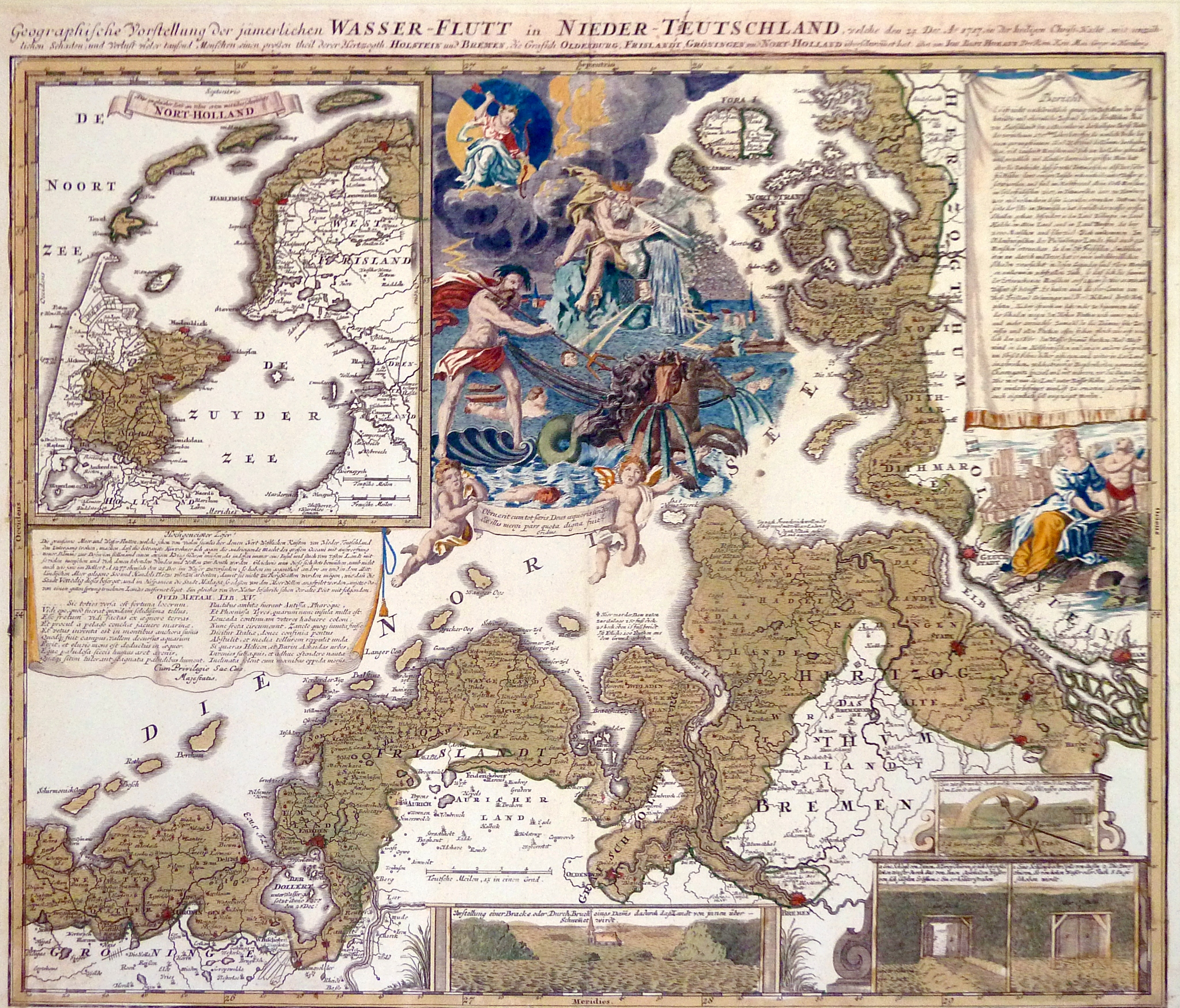
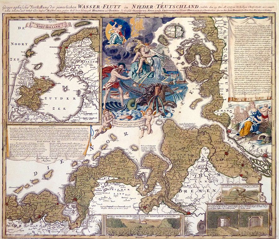
English: The Christmas flood of 1717 Deutsch: Geographische Vorstellung der jämmerlichen WASSER-FLUTT in NIEDERTEUTSCHLAND, welche den 25.Dec. Ao. 1717, in der heiligen Christ-Nacht, mit unzählichen Schaden und Verlust vieler tausend Menschen einen großen theil derer Hertzogth. HOLSTEIN und BREMEN, die Grafsch. OLDENBURG, FRISLANDT, GRÖNINGEN und NORT-HOLLAND überschwemmet hat. |
|||||||||||||||||||||||
| Date | ||||||||||||||||||||||||
| Source | http://www.ich-war-hier.de/wp-content/uploads/2012/03/P1040061.jpg | |||||||||||||||||||||||
| Author |
|
|||||||||||||||||||||||
| Permission (Reusing this file) |
|
|||||||||||||||||||||||
| Other versions |
|
|||||||||||||||||||||||
.jpg)


File history
Click on a date/time to view the file as it appeared at that time.
| Date/Time | Thumbnail | Dimensions | User | Comment | |
|---|---|---|---|---|---|
| current | 09:04, 6 November 2013 | | 2,048 × 1,749 (2.46 MB) | Matthias Süßen (talk | contribs) | {{Information |Description={{en|1=The Christmas flood of 1717}}{{de|1=Geographische Vorstellung der jämmerlichen WASSER-FLUTT in NIEDERTEUTSCHLAND, welche den 25.Dec. Ao. 1717, in der heiligen Christ-Nacht, mit unzählichen Schaden und Verlust vieler ... |
You cannot overwrite this file.
File usage on Commons
The following 5 pages use this file:
File usage on other wikis
The following other wikis use this file:
- Usage on af.wikipedia.org
- Usage on cs.wikipedia.org
- Usage on de.wikipedia.org
- Usage on fr.wikipedia.org
- Usage on nds.wikipedia.org
- Usage on nl.wikipedia.org
- Usage on pl.wikipedia.org
- Usage on sl.wikipedia.org
- Usage on uk.wikipedia.org
- Usage on www.wikidata.org
Metadata
Categories:
- Christmas flood 1717
- Johann Baptist Homann
- Old weather and climate maps
- 1718 maps of Europe
- Maps of weather in 1717
- Maps of floods
- Maps of weather and climate of Denmark
- 1710s maps of Denmark
- Old maps of Lower Saxony
- Lower Saxony in the 1710s
- Old maps of Schleswig-Holstein
- 1710s maps of the Netherlands
- Maps of weather events in the Netherlands
- Hydrographic maps of the Netherlands
- Maps of East Frisia
- 18th-century diagrams
- Maps of the Dollard