File:Western sahara moroccan walls topographic map-en.svg
Jump to navigation
Jump to search

Size of this PNG preview of this SVG file: 711 × 600 pixels. Other resolutions: 285 × 240 pixels | 569 × 480 pixels | 911 × 768 pixels | 1,214 × 1,024 pixels | 2,429 × 2,048 pixels | 1,187 × 1,001 pixels.
Original file (SVG file, nominally 1,187 × 1,001 pixels, file size: 1.06 MB)
Captions
Captions
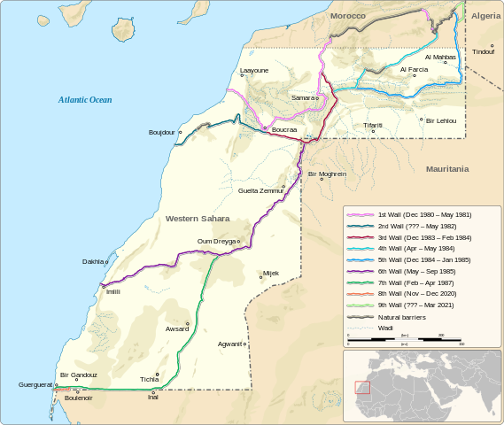
Location of the Moroccan sand walls in the Western Sahara
Summary
[edit]| Description |
English: Location of the Moroccan sand walls in the Western Sahara
|
||||||||||||||
| Date | |||||||||||||||
| Source |
Own work based on: Information from:
|
||||||||||||||
| Author | Goran_tek-en | ||||||||||||||
| Permission (Reusing this file) |
This file is licensed under the Creative Commons Attribution-Share Alike 4.0 International license. Attribution: Goran_tek-en
|
||||||||||||||
| Other versions |
|
||||||||||||||
| SVG development | This vector image was created with Inkscape. |
||||||||||||||


| Object location | | View this and other nearby images on: OpenStreetMap |
|---|


File history
Click on a date/time to view the file as it appeared at that time.
| Date/Time | Thumbnail | Dimensions | User | Comment | |
|---|---|---|---|---|---|
| current | 12:32, 15 July 2023 | | 1,187 × 1,001 (1.06 MB) | Goran tek-en (talk | contribs) | Updated with wall 9 as requested by Antemister |
| 17:28, 25 September 2022 |  | 1,187 × 1,001 (1.05 MB) | Goran tek-en (talk | contribs) | {{Information |description ={{en|Location of the Moroccan sand walls in the Western Sahara}} {{Institution |wikidata=Q510052}} {{Institution |wikidata=Q6250}} |date =2022-09-25 |source ={{Own based|Western sahara walls moroccan map-en.svg|Maps template-en.svg|BlankMap-World gray.svg|b1=M0tty|b2=Sting|b3=LivingShadow}} <br> Derived from; *[https://www.openstreetmap.org/#map=7/24.617/-13.513&layers=C OSM] Information from: *[https://googleearthcommunity.proboards.com/... |
You cannot overwrite this file.
File usage on Commons
The following 12 pages use this file:
- User:Goran tek-en/Gallery/2022
- File:Western sahara territorial control 1976-1979 topographic map-en.svg
- File:Western sahara territorial control 1979-1981 topographic map-en.svg
- File:Western sahara territorial control topographic map-en.svg
- File:Western sahara walls moroccan.png
- File:Western sahara walls moroccan map-ar.svg
- File:Western sahara walls moroccan map-de.svg
- File:Western sahara walls moroccan map-en.svg
- File:Western sahara walls moroccan map-es.svg
- File:Western sahara walls moroccan map-eu.svg
- File:Western sahara walls moroccan map-fr.svg
- Template:Other versions/Western Sahara walls map
File usage on other wikis
The following other wikis use this file:
- Usage on ru.wikipedia.org