File:Westernsaharamapunlabeled.png
Jump to navigation
Jump to search

Size of this preview: 602 × 599 pixels. Other resolutions: 241 × 240 pixels | 482 × 480 pixels | 1,009 × 1,004 pixels.
Original file (1,009 × 1,004 pixels, file size: 157 KB, MIME type: image/png)
Captions
Captions
Add a one-line explanation of what this file represents
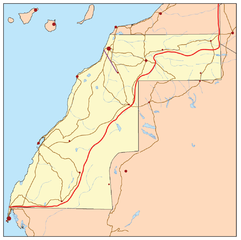
| Description | This is a general map of Western Sahara. | |||
| Date | ||||
| Source | Own work based primarily on the Digital Chart of the World. With this UN map and commercial atlases (Rand McNally, Google, Encarta, and National Geographic) used as references. | |||
| Author | Kmusser | |||
| Permission (Reusing this file) |
I, the copyright holder of this work, hereby publish it under the following license: This file is licensed under the Creative Commons Attribution-Share Alike 2.5 Generic license.
|
|||
| Other versions |
The English language version of this map is at image:Westernsaharamap.png
|


File history
Click on a date/time to view the file as it appeared at that time.
| Date/Time | Thumbnail | Dimensions | User | Comment | |
|---|---|---|---|---|---|
| current | 14:34, 2 February 2007 | | 1,009 × 1,004 (157 KB) | Kmusser (talk | contribs) | This is a general map of Western Sahara based primarily on the Digital Chart of the World. With [http://www.un.org/depts/Cartographic/map/dpko/minurso.pdf this UN map] and commercial atlases (Ran |
You cannot overwrite this file.
File usage on Commons
The following page uses this file: