File:WuerzburgPano1024.jpg
Jump to navigation
Jump to search
Size of this preview: 799 × 189 pixels. Other resolutions: 320 × 76 pixels | 640 × 151 pixels | 1,024 × 242 pixels | 1,280 × 303 pixels | 4,328 × 1,024 pixels.
Original file (4,328 × 1,024 pixels, file size: 2.05 MB, MIME type: image/jpeg)
Captions
Captions
Add a one-line explanation of what this file represents
Summary
[edit]| Description |
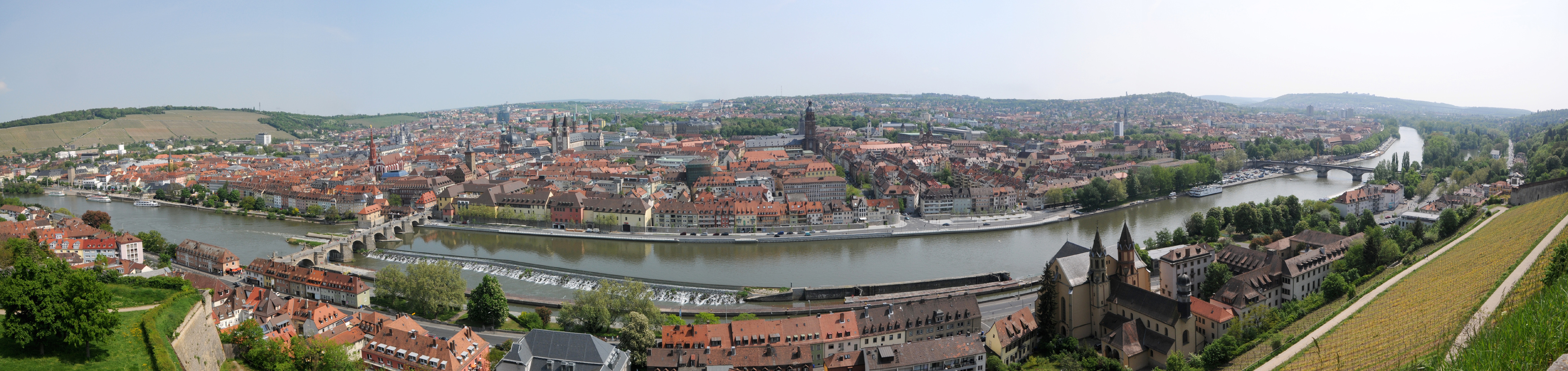
Deutsch: Panorama Würzburg, Blick von der Feste Marienberg auf Main und Innenstadt
English: Panorama Würzburg, view from castle Marienberg to river Main and city |
| Date | Taken on 3 May 2009 |
| Source | Own work |
| Author | Hubert Berberich (HubiB) |
| Permission (Reusing this file) |
Author: Hubert Berberich, see below |
| Camera location | | View this and other nearby images on: OpenStreetMap |
|---|
Licensing
[edit]This file is licensed under the Creative Commons Attribution-Share Alike 3.0 Unported license.
- You are free:
- to share – to copy, distribute and transmit the work
- to remix – to adapt the work
- Under the following conditions:
- attribution – You must give appropriate credit, provide a link to the license, and indicate if changes were made. You may do so in any reasonable manner, but not in any way that suggests the licensor endorses you or your use.
- share alike – If you remix, transform, or build upon the material, you must distribute your contributions under the same or compatible license as the original.
| Annotations | This image is annotated: View the annotations at Commons |


File history
Click on a date/time to view the file as it appeared at that time.
| Date/Time | Thumbnail | Dimensions | User | Comment | |
|---|---|---|---|---|---|
| current | 13:28, 12 June 2009 | 4,328 × 1,024 (2.05 MB) | HubiB (talk | contribs) | {{Information |Description = {{de|Panorama Würzburg, Blick von der Feste Marienberg auf Main und Innenstadt}} {{en|Panorama Würzburg, view from castle Marienberg to river Main and city}} |Source = own work |Date = 2009-05-03 (photo taken on that day) |A |
You cannot overwrite this file.
File usage on Commons
There are no pages that use this file.