File:ZatokaPuckaXVIIwiek-Wladyslawowo.jpg

Original file (1,018 × 1,439 pixels, file size: 552 KB, MIME type: image/jpeg)
Captions
Captions
| DescriptionZatokaPuckaXVIIwiek-Wladyslawowo.jpg |
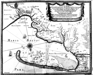
Polski: :• mapa Zatoki Puckiej sporządzona przez szwedzkiego kartografa E. Dahlberga na podstawie mapy F. Getkanta i opublikowana w Norymberdze w 1696 roku w opracowaniu Samuela von Pufendorfa pt. "De rebus de Carolo Gustavo gestis", str. 66, tabl. 8
|
|||||
| Date | ||||||
| Source |
|
|||||
| Author | drawn by: F. Getkant, E. Dahlberg | |||||
| Permission (Reusing this file) |
|
|||||
| Other versions |
 |
|||||
File history
Click on a date/time to view the file as it appeared at that time.
| Date/Time | Thumbnail | Dimensions | User | Comment | |
|---|---|---|---|---|---|
| current | 18:31, 30 September 2009 |  | 1,018 × 1,439 (552 KB) | Julo (talk | contribs) | {{Information |Description={{pl|1= <br> ;kolaż dwóch fotokopii z książki ''Ziemia pucka - przeszłość i teraźniejszość'' :• mapa Zatoki Puckiej sporządzona przez szwedzkiego kartografa E. Dahlberga na podstawie mapy [[:w:F |
You cannot overwrite this file.
File usage on Commons
The following page uses this file:
File usage on other wikis
The following other wikis use this file:
- Usage on pl.wikipedia.org
Metadata
This file contains additional information such as Exif metadata which may have been added by the digital camera, scanner, or software program used to create or digitize it. If the file has been modified from its original state, some details such as the timestamp may not fully reflect those of the original file. The timestamp is only as accurate as the clock in the camera, and it may be completely wrong.
| _error | 0 |
|---|