File talk:Somali Civil War (2009-present).svg
Khatumo state control is wrong
[edit].svg&action=edit§ion=1)
This map shows Khatumo as in control of a huge swath of territory between Somaliland and puntland. This is not reflected in the sources available. Las Anod is firmly in the control of Somaliland forces. Per this source [[1]] Buhoodle has fallen under the control of a local warlord who seized it from Khatumo forces.XavierGreen (talk) 18:55, 3 May 2016 (UTC)
.svg#c-XavierGreen-2016-05-03T18:55:00.000Z-Khatumo_state_control_is_wrong)
Legend
[edit].svg&action=edit§ion=2)
what is the meaning of blue (around Beledweyne and Merca)? --79.194.228.109 11:52, 27 May 2016 (UTC)
.svg#c-79.194.228.109-2016-05-27T11:52:00.000Z-Legend)
update
[edit].svg&action=edit§ion=3)
This needs an update. — Preceding unsigned comment was added by 108.4.159.12 (talk) 01:03, 27 October 2016 (UTC)
.svg#c-108.4.159.12-2016-10-27T01:03:00.000Z-update)
update 2018
[edit].svg&action=edit§ion=4)
If there are active members, can someone update the map--Murza-Zade (talk) 08:08, 20 September 2018 (UTC)
.svg#c-Murza-Zade-2018-09-20T08:08:00.000Z-update_2018)
The Puntland state itself is not marked...
[edit].svg&action=edit§ion=5)
If there is a separatly colored territory described as "Disputed territory between Somaliland and Puntland" then it is really peculiar that the Puntland state is not. 5.174.153.75 08:48, 7 January 2023 (UTC)
.svg#c-5.174.153.75-20230107084800-The_Puntland_state_itself_is_not_marked...)
Some changes
[edit].svg&action=edit§ion=6)
Somali forces recaptured Haradhere (see the article about Somali civil war (2009- )). See here: Somali Forces Capture Two Towns from Militants. voanews. Voice of America. Retrieved on 19 January 2023. Пан Хаунд (talk) 14:32, 2 March 2023 (UTC)
.svg#c-Пан_Хаунд-20230302143200-Some_changes)
Changes
[edit].svg&action=edit§ion=7)
The areas/towns of Rab Dhuure, Burgabo, and Qanadala have been recaptured from Al-Shabaab/ISIS, and the town/area of Fafahdun has been captured by Al-Shabaab. RowanJ LP2 (talk) 21:04, 29 October 2023 (UTC)
.svg#c-RowanJ_LP2-20231029210400-Changes)
Most recent map by REACH and Unosat
[edit].svg&action=edit§ion=8)
https://twitter.com/EmreAltinbas89/status/1736864862611845259 Billboardbillal (talk) 07:51, 26 December 2023 (UTC)
.svg#c-Billboardbillal-20231226075100-Most_recent_map_by_REACH_and_Unosat)
Updating northern region.
[edit].svg&action=edit§ion=9)
The borders between Somaliland and Puntland have remained unchanged since 2020.
I've revised the map due to numerous developments in the last four years within the disputed territory, notably Puntland holding voter registration in all of Eastern Sanaag in 2023 and the current frontlines between Somaliland and SSC-Khaatumo have moved away from Las Anod to Oog/Guumays.
I've additionally removed the Khatumo and disputed Puntland shading, as both entities are under the Somali government. Sifeeye (talk) 23:03, 12 January 2024 (UTC)
.svg#c-Sifeeye-20240112230300-Updating_northern_region.)
- @Hawkers994 Why revert the changes I've made? I've linked my sources above, what are your sources that Somaliland control anything east of Oog or Erigavo? Sifeeye (talk) 17:26, 18 January 2024 (UTC)
- Undependable source, no were in the article does it state sanaag or places are under militia control. The last reliable source is correctly used which correlates to that particular file. Hawkers994 (talk) 20:26, 18 January 2024 (UTC)
- If HiiraanOnline is undependable for you, then there are also articles and reports from reputable sources such as the International Crisis Group that have reported on recent frontline changes in Sool.
- On the Horizon: October 2023-March 2024 | Crisis Group
The new frontlines between Dhulbahante clan militias and government forces stablised in September after the Dhulbahante captured several army positions near Las Anod, the capital of Sool region, effectively driving Somaliland forces out of Dhulbahante territory.
A spark from either side could set off new fighting on the frontline between Oog and Guumays towns in Sool.
- I've also linked the results of Puntland's voter registration from the Transitional Puntland Electoral Commission's official Facebook page. The post includes a full breakdown of all polling stations' locations in Sanaag. You can see the villages and towns in Erigabo district that took part in the voter registration but are currently wrongly listed as controlled by Somaliland forces.
- This map shows how the situation in the Somali Civil War keeps changing, it's absurd that you're clinging to a four year old version and refusing to consider any new sources. Sifeeye (talk) 22:23, 18 January 2024 (UTC)
- The whole map is incorrect. There is no gabiley under Berbera location, which is why it’s an incorrect revert Hawkers994 (talk) 08:54, 28 February 2024 (UTC)
- @Hawkers994: Can you explain this a little more. Gabiley seems to be in the same location and under the control of Somaliland in the other versions. We cannot keep using a 2020 version of this conflict, what changes would you be OK with to bring an accurate map of this conflict up to date with 2024? Would you agree to Freetrashbox's proposal below? Abzeronow (talk) 17:52, 28 February 2024 (UTC)
- I think they're talking about how Gabiley is in the wrong location and how that invalidates the new map. It also invalidates the old map so I'm not sure why this line is being used. But they are correct about how there is no town called Gabiley (or at least no notable one) southeast of Berbera like the new and old map show. You can see by checking other maps but the town of Gabiley is in reality located a tad northwest of Hargeisa. Like it is here https://en.wikipedia.org/wiki/Template:Somali_Civil_War_detailed_map. Overall I think Freetrashbox's proposal would be agreeable, though Gabiley should be relocated so the conversation can be focused on the real issue at hand, that being source dependability.
- Ope. I think I found the origin of the error. As you can see here https://maps.lib.utexas.edu/maps/tpc/txu-pclmaps-oclc-22834566_k-6d.jpg (Center left of 6-1) there is a spring called Karin Gabiile, or just Gabileh here https://maps.lib.utexas.edu/maps/onc/txu-pclmaps-oclc-8322829_k_6.jpg (Bottom center of 7-1) Both are topographic maps from Perry-Castañeda Library Map Collection https://maps.lib.utexas.edu/maps/topo/ AVeryBigHat (talk) 18:30, 30 April 2024 (UTC)
- Ah, OK. I would agree that the location of Gabiley should be fixed. Abzeronow (talk) 18:36, 30 April 2024 (UTC)
- @Hawkers994: Can you explain this a little more. Gabiley seems to be in the same location and under the control of Somaliland in the other versions. We cannot keep using a 2020 version of this conflict, what changes would you be OK with to bring an accurate map of this conflict up to date with 2024? Would you agree to Freetrashbox's proposal below? Abzeronow (talk) 17:52, 28 February 2024 (UTC)
- The whole map is incorrect. There is no gabiley under Berbera location, which is why it’s an incorrect revert Hawkers994 (talk) 08:54, 28 February 2024 (UTC)
- Undependable source, no were in the article does it state sanaag or places are under militia control. The last reliable source is correctly used which correlates to that particular file. Hawkers994 (talk) 20:26, 18 January 2024 (UTC)
.svg#c-Sifeeye-20240118172600-Sifeeye-20240112230300)
.svg#c-Hawkers994-20240118202600-Sifeeye-20240118172600)
.svg#c-Sifeeye-20240118222300-Hawkers994-20240118202600)
.svg#c-Hawkers994-20240228085400-Sifeeye-20240118222300)
.svg#c-Abzeronow-20240228175200-Hawkers994-20240228085400)
.svg#c-AVeryBigHat-20240430183000-Abzeronow-20240228175200)
.svg#c-Abzeronow-20240430183600-AVeryBigHat-20240430183000)
Both are inappropriate. The map of Hawkers994 shows Las Anod, which is not controlled by Somaliland, as being under Somaliland control. However, that is clearly wrong, and there are a number of sources that indicate that Somaliland has withdrawn from Las Anod. On the other hand, Sifeeye's map lacks evidence. Cities such as Badhan, Buuhoodle, and Las Anod on this map are not under Somaliland control, but the towns in between are unknown, with a few exceptions. My suggestion is that the area that the two are disputing should be entered as a "Disputed Area" as indicated by the BBC, and only towns that are known to belong should be entered separately. Freetrashbox (talk) 12:50, 29 January 2024 (UTC)
.svg#c-Freetrashbox-20240129125000-Updating_northern_region.)
- This sounds like a reasonable compromise. Abzeronow (talk) 17:30, 29 January 2024 (UTC)
.svg#c-Abzeronow-20240129173000-Freetrashbox-20240129125000)
- UNOSAT is the United Nations Satellite Centre, and is a reliable source and is recent (December 2023). This map by them suggests the map of Sifeeye is for the most part correct and up-to-date. Billboardbillal (talk) 21:49, 29 January 2024 (UTC)
- There is no evidence that UNOSAT created the linked map. Freetrashbox (talk) 11:11, 30 January 2024 (UTC)
.svg#c-Billboardbillal-20240129214900-Freetrashbox-20240129125000)
.svg#c-Freetrashbox-20240130111100-Billboardbillal-20240129214900)
Map conflicts
[edit].svg&action=edit§ion=10)
@Sifeeye, Hawkers994, AVeryBigHat, Abzeronow, Freetrashbox, Billboardbillal, and Ecrusized:
Ok so I've reverted back to the map which shows Khatumo State with that large swath of land as per a map from the Crsis Group which I believe is pretty reliable. More specifically it states in another issue that the "Front line shifted away from Sool region’s capital Las Anod. Following Dhulbahante militiamen’s major victory with Aug capture of Goojacade army base near Las Anod, new front line emerged between Oog and Guumays villages in western Sool. New division corresponds roughly to boundaries between Isaaq and Dhulbahante clans, with Isaaq being dominant grouping in Somaliland." According to its newest issue the frontline has remianed the same with a lull in fighting.
Hawkers994 says that map is wrong tho but he has not provided sources saying that his is right and I couldn't find it in the changes. I don't think it's reaonable to use an old map just because a place is in a wrong location.
The map apparently from the UNOSAT links back to reddit, which isn't a reliable source.
Concerning Al-Shabaab control, I know nothing about lol but that's where the most difference seems to be. The current map for Al-Shabaab control I believe comes from Political Geography Now which dates back to 2021 (3 year old) and I have no idea the reliablity of. I think that map of control also incorperates a newer 2023 issue (1 year old) for the Harhardhere area.
Again I don't know the source for the other map of its control because there's no source listed for it in the section above.
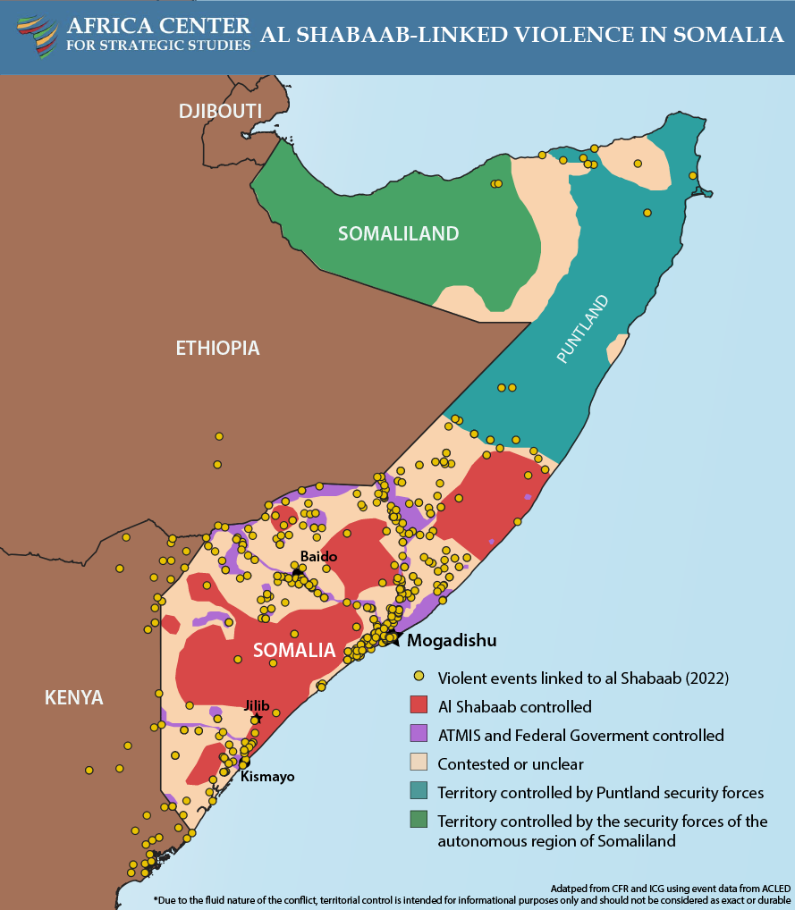
There's also a 2022 (2 year old) map from the African Center for Strategic Studies which gives Al-Sabaab a lot of control.
Lastly, there's map pushed by Ecrusized on both of the Somali Civil War main pages which gives Al-Sabaab even more control. This maps cites a tw itter post which is something I would not consider reliable. It also does not include Khatumo territory such as Las Anod.
Oh and there's also the Module:Somali Civil War detailed map which is all over the place.
Wowzers122 (talk) 15:49, 31 May 2024 (UTC)
.svg#c-Wowzers122-20240531154900-Map_conflicts)
- @Wowzers122: I'm not "pushing" anything and I have no personal interest in these maps. The current map, including the one you've added does not have a single reference. For that reason I replaced it with what I could find. The references you've listed above are dating back to 2021 and 2023, prior to the File:Somali Al-Shabaab Offensive (2022-23).svg. (The sourcing of this file is in the talk page).
- Apologies if my previous message was unclear. I didn't mean "pushing" in a negative way, nor did I imply any personal interest in the maps on your part. I mentioned you because you created a map that conflicts with another one, and that map was added to the main pages by you. My concern is that there should be consensus on the differences instead of having multiple conflicting maps. Another issue is the lack of sources. I started the discussion to find sources for an up-to-date map since there was some conversation happening here awhile back. I reverted to the previous map because it showed Khatumo State, which controls that territory, unlike the other map. Like I said I know nothing of the southern conflict and just stated references I found in the file changes. I stated the years because they were of concern to me. I couldn't find sources in the file changes for the other map version, as I previously mentioned. Wowzers122 (talk) 21:30, 2 June 2024 (UTC)
- @Wowzers122: ... You are not addressing the primary issue here which are citations. I came across that Twitter post a few days ago and decided the create a new file because the old one was not citing ANYTHING. Which is a common issue in most Wikipedia maps. "modules" citing other Wikipedia pages are not citations. I uploaded a new file, because I know many users tend to edit war in these war map files. I didn't modify anything except what was precisely shown in the twitter post which I cited. It is currently the only map showing the Somali Civil War that actually cites a source. It is also up to date. Please adress this first. The account cited belongs to this news website: https://actafabula.net/ Ecrusized (talk) 21:56, 2 June 2024 (UTC)
- Yes, the lack of sources is also a concern of mine, but I am not suggesting using modules or Wikipedia as a source. I apologize for not noticing that the account was linked to an actual news site and that it is their official account. I now believe that your map the best version to use for the main pages. However, it lacks a citation for the conflict in the north, which should at least show the disputed territory between Khatumo State and Somaliland. You criticize this map for having no sources, but yours cites this map as a source for the north. I've provided a source from the Crisis Group for the conflict there, and another person below cited a BBC article showing the disputed area. Wowzers122 (talk) 22:26, 2 June 2024 (UTC)
- I could adjust Somaliland as its seen in this file or here File:Somaliland (orthographic projection).svg. Otherwise you can modify the file I've uploaded and post it here and I can save it, or you can request overwrite access on my file, however, I wouldn't suggest the latter tends to result in edit warring between editors. Ecrusized (talk) 23:13, 2 June 2024 (UTC)
- Yes, the lack of sources is also a concern of mine, but I am not suggesting using modules or Wikipedia as a source. I apologize for not noticing that the account was linked to an actual news site and that it is their official account. I now believe that your map the best version to use for the main pages. However, it lacks a citation for the conflict in the north, which should at least show the disputed territory between Khatumo State and Somaliland. You criticize this map for having no sources, but yours cites this map as a source for the north. I've provided a source from the Crisis Group for the conflict there, and another person below cited a BBC article showing the disputed area. Wowzers122 (talk) 22:26, 2 June 2024 (UTC)
- @Wowzers122: ... You are not addressing the primary issue here which are citations. I came across that Twitter post a few days ago and decided the create a new file because the old one was not citing ANYTHING. Which is a common issue in most Wikipedia maps. "modules" citing other Wikipedia pages are not citations. I uploaded a new file, because I know many users tend to edit war in these war map files. I didn't modify anything except what was precisely shown in the twitter post which I cited. It is currently the only map showing the Somali Civil War that actually cites a source. It is also up to date. Please adress this first. The account cited belongs to this news website: https://actafabula.net/ Ecrusized (talk) 21:56, 2 June 2024 (UTC)
- Apologies if my previous message was unclear. I didn't mean "pushing" in a negative way, nor did I imply any personal interest in the maps on your part. I mentioned you because you created a map that conflicts with another one, and that map was added to the main pages by you. My concern is that there should be consensus on the differences instead of having multiple conflicting maps. Another issue is the lack of sources. I started the discussion to find sources for an up-to-date map since there was some conversation happening here awhile back. I reverted to the previous map because it showed Khatumo State, which controls that territory, unlike the other map. Like I said I know nothing of the southern conflict and just stated references I found in the file changes. I stated the years because they were of concern to me. I couldn't find sources in the file changes for the other map version, as I previously mentioned. Wowzers122 (talk) 21:30, 2 June 2024 (UTC)
.svg)
.svg#c-Wowzers122-20240602213000-Wowzers122-20240531154900)
.svg#c-Ecrusized-20240602215600-Wowzers122-20240602213000)
.svg#c-Wowzers122-20240602222600-Ecrusized-20240602215600)
.svg)
.svg#c-Ecrusized-20240602231300-Wowzers122-20240602222600)

.
- @Wowzers122: I've modified the Somaliland border and restored the file on English Wikipedia page for Somali Civil War. Ecrusized (talk) 11:40, 7 June 2024 (UTC) thumb|right.
- In this wall of text, you are discrediting other sources you've found, and replacing it with Wikipedia module, that is again fully unreferenced. w:WP:NOTSOURCE. Ecrusized (talk) 19:10, 31 May 2024 (UTC)
- I am not replacing it with the Wikipedia module; in fact, I discredited it because, as I mentioned, it's all over the place. Additionally, I discredited yours because Twitter is not a reliable source and should not be used, which is what your map relies on. The only source I find that I believe is reliable is from the Crisis Group, but that only covers the north. I would like to thank you, however, for mentioning the sources in the talk of File:Somali Al-Shabaab Offensive (2022-23).svg as it seems to also be reliable. Wowzers122 (talk) 21:30, 2 June 2024 (UTC)
- In the discussion section above, it appears Gabiley's location is erroneous. That should be fixed. Abzeronow (talk) 19:18, 31 May 2024 (UTC)
- @Wowzers122: The Crsis Group's map does not show the Khatumo State's territory, it only shows that this is a disputed area, as does the BBC. In other words, the Crsis Group's map is also evidence that neither the designation of this area as Somalia (Khatumo State) nor Somaliland is neutral. Freetrashbox (talk) 05:53, 2 June 2024 (UTC)
- Are you sure? It does not state that it's the disputed territory, and as shown by the BBC map, the disputed area is more to the west. The Crisis Group page discusses the shift in the frontline which is why I believe it's showing the frontline. Plus, it also matches the description of the frontline from the same page which is "between Oog and Guumays villages in western Sool." Wowzers122 (talk) 21:59, 2 June 2024 (UTC)
- I agree with Freetrashbox that Khatumo State should be put as "disputed territory" separate from Somalia and Somaliland. Abzeronow (talk) 20:50, 2 June 2024 (UTC)
- I think this is a reasonable compromise as long as it also shows the places that we know for sure are in the hands of each. Wowzers122 (talk) 22:02, 2 June 2024 (UTC)
- Pinging @Wowzers122: once again. You do not appear to be responding to multiple users whom you have pinged including myself. Please provide explicitly what source you are using to update the file. As I've said above, Wikipedia is not a source. Neither is mixing multiple sources for obvious synthesis issues. Ecrusized (talk) 20:47, 2 June 2024 (UTC)
- Calm down I was uploading a mass amount of maps I had finished and then was going to respond to this. Wowzers122 (talk) 21:02, 2 June 2024 (UTC)
.svg#c-Ecrusized-20240607114000-Map_conflicts)
.svg#c-Ecrusized-20240531191000-Ecrusized-20240607114000)
.svg#c-Wowzers122-20240602213000-Ecrusized-20240531191000)
.svg#c-Abzeronow-20240531191800-Ecrusized-20240531191000)
.svg#c-Freetrashbox-20240602055300-Ecrusized-20240607114000)
.svg#c-Wowzers122-20240602215900-Freetrashbox-20240602055300)
.svg#c-Abzeronow-20240602205000-Freetrashbox-20240602055300)
.svg#c-Wowzers122-20240602220200-Abzeronow-20240602205000)
.svg#c-Ecrusized-20240602204700-Ecrusized-20240607114000)
.svg#c-Wowzers122-20240602210200-Ecrusized-20240602204700)
Issue about sources
[edit].svg&action=edit§ion=11)
.svg&action=edit&summary=Fulfilling+%5B%5BTemplate%3AEditprotected%7Cedit+request%5D%5D+by+Zabezt)
.svg&action=edit&summary=Fulfilling%20%5B%5BTemplate%3AEdit%20request%7Cedit%20request%5D%5D%20by%20%5B%5BUser%3AZabezt%7CZabezt%5D%5D.%20Thanks%20for%20helping%21)
The Map is wrong and poorly sourced. Zabezt (talk) 15:28, 28 August 2024 (UTC)
.svg#c-Zabezt-20240828152800-Issue_about_sources)
- Please detail why you think the map is wrong, using reliable sources. Abzeronow (talk) 17:48, 28 August 2024 (UTC)
- I can list why the source is wrong.
- It’s too simplified. The lines drawn are completely straight, which Ecrusized had to weirdly smooth out.
- It doesn’t know who is exactly fighting. The map shows Somaliland as an ally with Somalia helping them defeat Al-Shabaab. Which is obviously, not true.
- The map used in the background is really low quality. Just LOOK at Xaafun and Djibouti. I’m so confused on how this map is here, listed as a source on Wikipedia today.
- ISIS. I found no source on ISIS taking anymore territory since its arrival in 2015.
- Zabezt (talk) 17:58, 28 August 2024 (UTC)
- And for the Khatumo situation, Ecrusized used a map with no source, (which is literally his main argument) Please replace it (if you can) with the previous map under the files history, which sites these three sources; Political Geography Now The International Crisis Group and The International Crisis Group, Again. Zabezt (talk) 18:16, 28 August 2024 (UTC)
- I definitely agree that improvements should be made like demarcating Khatumo State as disputed territory, and the previous discussed error of Gabiley's location. On the question of making it clear that Somaliland, Somalia's federal government and Al-Shabaab are all different factions, what is your proposal to fix that? Abzeronow (talk) 18:19, 28 August 2024 (UTC)
- My proposal to fix all of this is to change the current map to this one. and to add back the sources I just mentioned. Zabezt (talk) 18:31, 28 August 2024 (UTC)
- That doesn't fix the Khatumo or Gabiley issue, and that map didn't have a consensus for it (as evidenced by reverts and previous discussion trying to come to a consensus on how the map is supposed to look). Abzeronow (talk) 18:39, 28 August 2024 (UTC)
- Then what should we do? We can’t just make a new map, this war rarely gets any attention. The source for the map I recommended is 3 years old! Finding a good source is like finding a needle in a haystack. Zabezt (talk) 18:45, 28 August 2024 (UTC)
- The only thing that can be done is try to find consensus for a particular map. I agree with my colleague Jmabel's action to protect the page. Compromises may have to be made, Wikimedia Commons is a collaborative project. I can agree there are flaws to Ecrusized's map, but the way forward to find agreement on how to fix it. Abzeronow (talk) 18:55, 28 August 2024 (UTC)
- Until we can all find an agreement, I’m gonna remove the maps on all of the Somali Civil War related articles. Zabezt (talk) 18:58, 28 August 2024 (UTC)
- The only thing that can be done is try to find consensus for a particular map. I agree with my colleague Jmabel's action to protect the page. Compromises may have to be made, Wikimedia Commons is a collaborative project. I can agree there are flaws to Ecrusized's map, but the way forward to find agreement on how to fix it. Abzeronow (talk) 18:55, 28 August 2024 (UTC)
- Then what should we do? We can’t just make a new map, this war rarely gets any attention. The source for the map I recommended is 3 years old! Finding a good source is like finding a needle in a haystack. Zabezt (talk) 18:45, 28 August 2024 (UTC)
- That doesn't fix the Khatumo or Gabiley issue, and that map didn't have a consensus for it (as evidenced by reverts and previous discussion trying to come to a consensus on how the map is supposed to look). Abzeronow (talk) 18:39, 28 August 2024 (UTC)
- My proposal to fix all of this is to change the current map to this one. and to add back the sources I just mentioned. Zabezt (talk) 18:31, 28 August 2024 (UTC)
- I definitely agree that improvements should be made like demarcating Khatumo State as disputed territory, and the previous discussed error of Gabiley's location. On the question of making it clear that Somaliland, Somalia's federal government and Al-Shabaab are all different factions, what is your proposal to fix that? Abzeronow (talk) 18:19, 28 August 2024 (UTC)
- And for the Khatumo situation, Ecrusized used a map with no source, (which is literally his main argument) Please replace it (if you can) with the previous map under the files history, which sites these three sources; Political Geography Now The International Crisis Group and The International Crisis Group, Again. Zabezt (talk) 18:16, 28 August 2024 (UTC)
- I can list why the source is wrong.
.svg#c-Abzeronow-20240828174800-Zabezt-20240828152800)
.svg#c-Zabezt-20240828175800-Abzeronow-20240828174800)
.svg#c-Zabezt-20240828181600-Zabezt-20240828175800)
.svg#c-Abzeronow-20240828181900-Zabezt-20240828181600)
.svg#c-Zabezt-20240828183100-Abzeronow-20240828181900)
.svg#c-Abzeronow-20240828183900-Zabezt-20240828183100)
.svg#c-Zabezt-20240828184500-Abzeronow-20240828183900)
.svg#c-Abzeronow-20240828185500-Zabezt-20240828184500)
.svg#c-Zabezt-20240828185800-Abzeronow-20240828185500)
Zabezt, I see "edit request" template. Can you state what you want to edit? --Jarekt (talk) 15:44, 29 August 2024 (UTC)
.svg#c-Jarekt-20240829154400-Issue_about_sources)
- The map, the previous map under the files history DOES have sources, I found them. They are Political Geography Now, and The International Crisis Group, twice. The reason Ecrusized changed the map is because the previous one didn’t have a source, and now since sources was found, his edit is no longer necessary. Zabezt (talk) 23:07, 29 August 2024 (UTC)
- Those look like probably respectable sources. That said, they represent 2021 and two even more recent dates, respectively. I still have no answer to my question in the next section as to what this map is even supposed to represent. - Jmabel ! talk 04:48, 30 August 2024 (UTC)
.svg#c-Zabezt-20240829230700-Jarekt-20240829154400)
.svg#c-Jmabel-20240830044800-Zabezt-20240829230700)
.svg)
.svg#c-Zabezt-20240830131400-Jmabel-20240830044800)
What date is this map intended to reflect?
[edit].svg&action=edit§ion=12)
The name says "present" but the categories say 2016. Should this map be frozen at 2016 (and renamed accordingly), or should it be marked {{Current}} (and categories changed accordingly)? - Jmabel ! talk 18:31, 28 August 2024 (UTC)
.svg#c-Jmabel-20240828183100-What_date_is_this_map_intended_to_reflect?)
- @Sifeeye, Hawkers994, AVeryBigHat, Freetrashbox, Billboardbillal, and Ecrusized: to get feedback on this. Abzeronow (talk) 18:41, 28 August 2024 (UTC)
.svg#c-Abzeronow-20240828184100-Jmabel-20240828183100)
Sourcing.
[edit].svg&action=edit§ion=13)
@Ecrusized, under the request of @Cullen328, I want to have a discussion with you about these maps. Zabezt (talk) 04:36, 29 August 2024 (UTC)
.svg#c-Zabezt-20240829043600-Sourcing.)
- The discussion should also take place on the talk pages of the two English Wikipedia articles where the map is in dispute. Cullen328 (talk) 04:41, 29 August 2024 (UTC)
- Gotcha. Zabezt (talk) 04:42, 29 August 2024 (UTC)
- Consider this: Perhaps this map reflects the situation in 2016 when the map was created, and perhaps the situation is considerably different in 2024. That does not mean the map should be deleted. Maybe the map can be captioned better and a similar map created showing the changed situation in 2024. Cullen328 (talk) 04:45, 29 August 2024 (UTC)
- That’s smart, I’ll try to mention that! Zabezt (talk) 04:49, 29 August 2024 (UTC)
- I've already explained to you that the previous map does not cite any sources and this one does. Ecrusized (talk) 10:38, 29 August 2024 (UTC)
- Yes, but then I did find the source for the map under the files history, and you still removed it for the same reason. Zabezt (talk) 12:13, 29 August 2024 (UTC)
- @Ecrusized The map you made severely overestimates the territory held by Al-Shabaab. In-fact it conflates presence and actual integral control. There needs to be a consensus reached as I have already found an issue such as El-Wak, Somalia claimed to be under Al-Shabaab when it was recaptured by SNA and AMISOM forces in 2019 [2] Replayerr (talk) 14:51, 30 August 2024 (UTC)
- 2019 was 5 years ago. The map is dated to May of this year, and includes the gains of Al-Shabaab made since 2022. Ecrusized (talk) 21:31, 30 August 2024 (UTC)
- Again: what date is this file supposed to represent? - Jmabel ! talk 22:03, 30 August 2024 (UTC)
- 2019 was 5 years ago. The map is dated to May of this year, and includes the gains of Al-Shabaab made since 2022. Ecrusized (talk) 21:31, 30 August 2024 (UTC)
- I've already explained to you that the previous map does not cite any sources and this one does. Ecrusized (talk) 10:38, 29 August 2024 (UTC)
- That’s smart, I’ll try to mention that! Zabezt (talk) 04:49, 29 August 2024 (UTC)
- Consider this: Perhaps this map reflects the situation in 2016 when the map was created, and perhaps the situation is considerably different in 2024. That does not mean the map should be deleted. Maybe the map can be captioned better and a similar map created showing the changed situation in 2024. Cullen328 (talk) 04:45, 29 August 2024 (UTC)
- Gotcha. Zabezt (talk) 04:42, 29 August 2024 (UTC)
.svg#c-Cullen328-20240829044100-Zabezt-20240829043600)
.svg#c-Zabezt-20240829044200-Cullen328-20240829044100)
.svg#c-Cullen328-20240829044500-Zabezt-20240829044200)
.svg#c-Zabezt-20240829044900-Cullen328-20240829044500)
.svg#c-Ecrusized-20240829103800-Zabezt-20240829044900)
.svg#c-Zabezt-20240829121300-Ecrusized-20240829103800)
.svg#c-Replayerr-20240830145100-Ecrusized-20240829103800)
.svg#c-Ecrusized-20240830213100-Replayerr-20240830145100)
.svg#c-Jmabel-20240830220300-Ecrusized-20240830213100)
Sourcing. (continued)
[edit].svg&action=edit§ion=14)
I'm simply want to settle this map with you. I assure you I'm not a sockpuppet account, or a bot. And even if I stop editing the file, more people will for years to come if you don't help to stop this mess. I have no idea why you're refusing to talk to me, I simply don't want your map up because I believe it's wrong and poorly sourced, and I don't want anymore major lies about my country. So please, just TALK to me. Zabezt (talk) 00:38, 29 August 2024 (UTC)
.svg#c-Zabezt-20240829003800-Sourcing._(continued))
- Can you at least tell me, THROUGHLY, why you're insisting that your map is correct on should be used on Wikipedia.? Zabezt (talk) 00:42, 29 August 2024 (UTC)
- I've already explained to you that the previous map does not cite any sources and this one does. Ecrusized (talk) 10:39, 29 August 2024 (UTC)
- What source did you cite? The source erroneously mentions that Al-Shabaab is still in places like Diinsoor which they were expelled by Amisom 9 years ago and current disputes are handled by the South-West State of Somalia, so the area connecting Diinsoor and Baidoa should be marked red.
- The road between between Baidoa and Mogadishu, notabaly including towns like Buur Hakaba, should be marked as red, albeit with Al-Shabaab presence in rural areas
- It even states that El-Wak is under Al-Shabaab control when there's AMISOM literally garrisoned there who visit often and aid locals with supplies. It was retaken by SNA in 2019.[3]
- I would like to know where you got the map source from and which year it was dated? This map by Koen Adams, dated in 2021 does not remotely put Al-Shabaab's territory at such size.[4]You tend to conflate one source and consider it the truth when you should be gathering multiple citations and reaching a consensus as I've already identified multiple errors with this. Replayerr (talk) 15:04, 30 August 2024 (UTC)
- To my understanding, the Al-Shabaab situation is completely sourced from A low quality map with 5K views posted by the Twitter account of an obscure and unreliable news cite. Ecrusized argues that he only made the map because the previous maps didn’t cite any sources, and he’s not really defending the map in any other way. Zabezt (talk) 15:49, 30 August 2024 (UTC)
- And this map came from May of this year. Zabezt (talk) 15:51, 30 August 2024 (UTC)
- It's the map of a news website (https://actafabula.net/). And the only source on Wikipedia that currently cites a map. If you can find a better source, the map can be replaced with that one. Ecrusized (talk) 21:30, 30 August 2024 (UTC)
- You can see the citation of the file in its description. It is entirely citing that source. Merging multiple sources is called WP:SYNTH and is not allowed. The source citated is dating to May 2024, so naturally one can expect changes from 9 years ago to have changed since then. Ecrusized (talk) 21:29, 30 August 2024 (UTC)
- @Ecrusized on Wikipedia, we do not use Twitter as a source as it is considered highly unreliable. From what I can see, the tweet only has 12 likes and doesn't cite any sources. Nor is the map included in the website(https://actafabula.net) and if it was, it. Do you have any sources that state El Wak to have been under Al-Shabaab control? 2019 isn't a change from "9 years ago".
- Unfortunately, the content you added to a Wikipedia article appears to be a minority or fringe viewpoint, and appears to have given undue weight to this minority viewpoint, and has been reverted. To maintain a neutral point of view, an idea that is not broadly supported by scholarship in its field must not be given undue weight in an article about a mainstream idea. Feel free to use the article's talk page to discuss this, and take a look at the welcome page to learn more about contributing to this encyclopedia.
- This is a poor attempt from your side to claim that it's WP:SYNTH when the map you used doesn't even include "SS-C Khatuumo" control or Somaliland control. [5] Replayerr (talk) 22:10, 30 August 2024 (UTC)
- I have already told this to several other editors. The only reason I updated the map in the first place is because the previous revisions did not cite any source. The reference may not be perfect, but its better than making a completely original research file. Ecrusized (talk) 22:34, 30 August 2024 (UTC)
- Also, the place for this discussion is not my talk page. Please move this to the article or the files talk page. Ecrusized (talk) 22:36, 30 August 2024 (UTC)
- The maps did cite sources, just not in the file's summary. If the source is not in the summary, check the files history or the talk page. Two of your sources are examples of this. This ones source is only on the file’s history and this ones source is only on the file’s talk page. Ecrusized (talk) 00:11, 31 August 2024 (UTC)
- @Zabezt and Replayerr: This discussion was moved to the appropriate place. Ecrusized (talk) 00:11, 31 August 2024 (UTC)
- And I don’t see how any of I sources I mentioned merge or contradict. (nvm found it.) Zabezt (talk) 00:07, 31 August 2024 (UTC)
- I've already pointed out multiple errors in the map, such as incorrectly labeling El Wak as being under Al-Shabaab control, which is simply not true. Additionally, conflating Al-Shabaab's control with their influence is misleading. I’ve mentioned before that Twitter is an unreliable source for this type of information.
- I also want to clarify that when creating a map related to a conflict, synthesising information from various sources is not only permitted but essential unless you're using a single source in the public domain. Wikipedia’s policy against synthesis does not apply here as strictly as it might in other contexts, especially on Commons as @Jmabel has mentioned.
- The collapse of logic is coming from your end. Where you state.
- - Adding multiple sources on the changing conflict is considered "WP:SYNTH"
- I have already told this to several other editors. The only reason I updated the map in the first place is because the previous revisions did not cite any source. The reference may not be perfect, but its better than making a completely original research file. Ecrusized (talk) 22:34, 30 August 2024 (UTC)
- To my understanding, the Al-Shabaab situation is completely sourced from A low quality map with 5K views posted by the Twitter account of an obscure and unreliable news cite. Ecrusized argues that he only made the map because the previous maps didn’t cite any sources, and he’s not really defending the map in any other way. Zabezt (talk) 15:49, 30 August 2024 (UTC)
- I've already explained to you that the previous map does not cite any sources and this one does. Ecrusized (talk) 10:39, 29 August 2024 (UTC)
.svg#c-Zabezt-20240829004200-Zabezt-20240829003800)
.svg#c-Ecrusized-20240829103900-Zabezt-20240829004200)
.svg#c-Replayerr-20240830150400-Ecrusized-20240829103900)
.svg#c-Zabezt-20240830154900-Replayerr-20240830150400)
.svg#c-Zabezt-20240830155100-Zabezt-20240830154900)
.svg#c-Ecrusized-20240830213000-Zabezt-20240830154900)
.svg#c-Ecrusized-20240830212900-Replayerr-20240830150400)
.svg#c-Replayerr-20240830221000-Ecrusized-20240830212900)
.svg#c-Ecrusized-20240830223400-Replayerr-20240830221000)
.svg#c-Ecrusized-20240830223600-Ecrusized-20240830223400)
.svg)
.svg)
.svg#c-Ecrusized-20240831001100-Ecrusized-20240830223400)
.svg#c-Ecrusized-20240831001100-Ecrusized-20240830223400-1)
.svg#c-Zabezt-20240831000700-Ecrusized-20240830223400)
When the map you cited doesn't have Somaliland or SSC-Khatuumo control while the one you made does which is also "WP:SYNTH" according to your logic then.
- I understand that "the previous map wasn't cited" but the rampant disinformation in the new one isn't any better.
- The 2021 map which I have previously cited [6] and with a new 2023 update which includes the Harardhere offensive [7]. Replayerr (talk) 09:24, 31 August 2024 (UTC)
- Why can’t we just use this map? for Al-Shabaab control, I’ve seen this map all over cites like Reddit, With this one specifically listing sources in the post’s comment section. And the file’s history too now that I think about it. Zabezt (talk) 23:03, 5 September 2024 (UTC)
@Zabezt: your link there ("this map") is precisely to the file for which this is the discussion page. I doubt that is what you meant to do. - Jmabel ! talk 00:22, 6 September 2024 (UTC)- Are you sure? From my end it’s using File:Somali Civil War (2009-present).png a different file. Zabezt (talk) 00:51, 6 September 2024 (UTC)
- @Zabezt: My apologies, it was late at night here and I didn't notice the "png" vs. "svg". - Jmabel ! talk 10:53, 6 September 2024 (UTC)
- Are you sure? From my end it’s using File:Somali Civil War (2009-present).png a different file. Zabezt (talk) 00:51, 6 September 2024 (UTC)
- I have no issues with using that map as it falls in line with most recent developments as seen here in this map which is sourced from here [8] which is a stark difference from a biased map found on Twitter. Replayerr (talk) 13:22, 14 September 2024 (UTC)
- How about ISIS? I’m yet to see one of those maps show ISIS control. Zabezt (talk) 14:37, 14 September 2024 (UTC)
- From what I know, ISIS has a presence in the Galgala mountains so a dark black radius around that area. Replayerr (talk) 22:12, 14 September 2024 (UTC)
- So if we take this map, update the Khatumo situation regarding the Las Anod Conflict, and add the Islamic state, it would be one of the most accurate maps we have? Zabezt (talk) 01:08, 15 September 2024 (UTC)
- Yes it would. Where would you update the Khatumo situation? Badhan is in dispute with Somaliland and Puntland and currently treated as a district as Puntland where they have forces stationed and built a university there. Replayerr (talk) 10:16, 15 September 2024 (UTC)
- Really? I was just gonna use the source on this map, which Wowzers122 found. Zabezt (talk) 13:54, 15 September 2024 (UTC)
- You can use this map as it seems to reflect the conflict in Somalia. I think everyone here has come to agreement on it. Replayerr (talk) 22:05, 15 September 2024 (UTC)
- Really? I was just gonna use the source on this map, which Wowzers122 found. Zabezt (talk) 13:54, 15 September 2024 (UTC)
- Yes it would. Where would you update the Khatumo situation? Badhan is in dispute with Somaliland and Puntland and currently treated as a district as Puntland where they have forces stationed and built a university there. Replayerr (talk) 10:16, 15 September 2024 (UTC)
- So if we take this map, update the Khatumo situation regarding the Las Anod Conflict, and add the Islamic state, it would be one of the most accurate maps we have? Zabezt (talk) 01:08, 15 September 2024 (UTC)
- From what I know, ISIS has a presence in the Galgala mountains so a dark black radius around that area. Replayerr (talk) 22:12, 14 September 2024 (UTC)
- How about ISIS? I’m yet to see one of those maps show ISIS control. Zabezt (talk) 14:37, 14 September 2024 (UTC)
- Why can’t we just use this map? for Al-Shabaab control, I’ve seen this map all over cites like Reddit, With this one specifically listing sources in the post’s comment section. And the file’s history too now that I think about it. Zabezt (talk) 23:03, 5 September 2024 (UTC)
- Okay, so I emailed ActaFabula, and they said their map shows not just control, but presence as well. Zabezt (talk) 20:59, 14 September 2024 (UTC)
- That's is what I assumed too, I even stated before presence ≠ actual control over the territory. We should have this map changed to the one we're discussing about and have it edited to include the ISIL faction and update the Khatumo situation. Replayerr (talk) 10:17, 15 September 2024 (UTC)
- I guess it's also "WP:SYNTH" as ActaFabula also used multiple sources(just joking) but that excuse used by the person who added the map in the article was not valid whatsoever. It should be changed now. Replayerr (talk) 10:19, 15 September 2024 (UTC)
.svg#c-Replayerr-20240831092400-Ecrusized-20240830223400)
.png)
.svg#c-Zabezt-20240905230300-Replayerr-20240831092400)
.svg#c-Jmabel-20240906002200-Zabezt-20240905230300)
.svg#c-Zabezt-20240906005100-Jmabel-20240906002200)
.svg#c-Jmabel-20240906105300-Zabezt-20240906005100)
.svg#c-Replayerr-20240914132200-Zabezt-20240905230300)
.svg#c-Zabezt-20240914143700-Replayerr-20240914132200)
.svg#c-Replayerr-20240914221200-Zabezt-20240914143700)
.svg#c-Zabezt-20240915010800-Replayerr-20240914221200)
.svg#c-Replayerr-20240915101600-Zabezt-20240915010800)
.svg#c-Zabezt-20240915135400-Replayerr-20240915101600)
.svg#c-Replayerr-20240915220500-Zabezt-20240915135400)
.svg#c-Zabezt-20240914205900-Ecrusized-20240829103900)
.svg#c-Replayerr-20240915101700-Zabezt-20240914205900)
.svg#c-Replayerr-20240915101900-Zabezt-20240914205900)
![]() Comment synthesis in creating a map related to a conflict is not only permitted, but close to mandatory unless your single source is in the public domain. Please do not confuse Wikipedia's policy against synthesis with being a Commons policy.
Comment synthesis in creating a map related to a conflict is not only permitted, but close to mandatory unless your single source is in the public domain. Please do not confuse Wikipedia's policy against synthesis with being a Commons policy.
If your source for the geography of the conflict is copyrighted, it is basically mandatory to take only information, not expression, from that source, which means you must synthesize that with a map from some other source. And saying you cannot use information from more than one source on a map is like saying a Wikipedia article couldn't cite multiple, possibly conflicting, sources. The issue is for it to be clear to the viewer of the map what information came from what source.
I still see no answer to what I asked in another section of this page: what date is this map intended to correspond to? The current title implies that it somehow shows what is now a 15-year span, which for a static image of a changing situation makes no sense at all.
If we have conflicting descriptions of the situation on the ground, possibly at various dates, from a variety of plausible sources, we should have numerous maps, probably one expressing information from each source we intend to use, and possibly others synthesizing information from multiple sources and/or dates. It seems like people have been arguing back and forth about creating one map that will be all things to all people in an obviously changing and sometimes murky situation. That, of course, is impossible to achieve. - Jmabel ! talk 01:47, 31 August 2024 (UTC)
.svg#c-Jmabel-20240831014700-Sourcing._(continued))
- What is the exact map you are taking about? Zabezt (talk) 01:50, 31 August 2024 (UTC)
- I'm talking about the current file. With no clear statement of what it is supposed to represent, of course you cannot agree on what content it should have. - Jmabel ! talk 15:38, 31 August 2024 (UTC)
- This map is from May 22, 2024. Zabezt (talk) 15:59, 31 August 2024 (UTC)
- Then why is 2009 in the title, and why is the date given as February 2016? - Jmabel ! talk 17:19, 31 August 2024 (UTC)
- I think the file is named that so it goes with Somali Civil War (2009-present) And this file was created in 2016, and it literally says to see the file’s history for the most recent date. Zabezt (talk) 17:38, 31 August 2024 (UTC)
- I guess that's OK. I will edit the description accordingly. And, given a great deal of "fog of war" in this case, whose description of the situation on the ground is this file supposed to represent? - Jmabel ! talk 20:25, 31 August 2024 (UTC)
- Ecrusized. Zabezt (talk) 20:35, 31 August 2024 (UTC)
- And by the way, he originally made his own file. but then he decided to upload the map to this file for whatever reason. Zabezt (talk) 20:39, 31 August 2024 (UTC)
- @Ecrusized and Zabezt: again, given that there clearly cannot be one, universally agreed upon version of this, it is important that it express whose information it is based on, and that presumably should not be a particular Commons user, it should be one or more reasonably reliable sources. Reliability here does not mean perfect accuracy -- I doubt even the Somali military or any of other combatants have a perfectly accurate picture of the situation -- but it means general reputability for being knowledgeable and honest about the matter. And if this is intended as the map of the (as closely as possible) current situation, we probably should be overt about differences in what different sources may say (e.g. a striped shading for areas where our sources don't agree).
- Again, I've only looked a little, but I hope we have many maps each showing what a particular source says was the situation on a particular date. - Jmabel ! talk 22:34, 31 August 2024 (UTC)
- Ecrusized. Zabezt (talk) 20:35, 31 August 2024 (UTC)
- Edited accordingly. Note that this included removing three categories that (presumably incorrectly) indicated that this map represents the situation in 2016. If anyone who cannot edit has categories they want to add instead, please let me know, but we do not want to add categories that will be continually changing. - Jmabel ! talk 20:32, 31 August 2024 (UTC)
- I guess that's OK. I will edit the description accordingly. And, given a great deal of "fog of war" in this case, whose description of the situation on the ground is this file supposed to represent? - Jmabel ! talk 20:25, 31 August 2024 (UTC)
- I think the file is named that so it goes with Somali Civil War (2009-present) And this file was created in 2016, and it literally says to see the file’s history for the most recent date. Zabezt (talk) 17:38, 31 August 2024 (UTC)
- Then why is 2009 in the title, and why is the date given as February 2016? - Jmabel ! talk 17:19, 31 August 2024 (UTC)
- This map is from May 22, 2024. Zabezt (talk) 15:59, 31 August 2024 (UTC)
- I'm talking about the current file. With no clear statement of what it is supposed to represent, of course you cannot agree on what content it should have. - Jmabel ! talk 15:38, 31 August 2024 (UTC)
.svg#c-Zabezt-20240831015000-Jmabel-20240831014700)
.svg#c-Jmabel-20240831153800-Zabezt-20240831015000)
.svg#c-Zabezt-20240831155900-Jmabel-20240831153800)
.svg#c-Jmabel-20240831171900-Zabezt-20240831155900)
.svg#c-Zabezt-20240831173800-Jmabel-20240831171900)
.svg#c-Jmabel-20240831202500-Zabezt-20240831173800)
.svg#c-Zabezt-20240831203500-Jmabel-20240831202500)
.svg#c-Zabezt-20240831203900-Zabezt-20240831203500)
.svg#c-Jmabel-20240831223400-Zabezt-20240831203500)
.svg&diff=prev&oldid=918010650)
.svg#c-Jmabel-20240831203200-Zabezt-20240831173800)
Trying to understand consensus
[edit].svg&action=edit§ion=15)
There is a lot above. Am I understanding that there is a different map somewhere on Commons that should be copied to this name? Also, either for the map as it stands, or for whatever is to replace it, can someone write down all relevant sources to credit as sources for the graphic or otherwise to be cited as providing information integrated into the map? Thanks. - Jmabel ! talk 12:28, 16 September 2024 (UTC)
.svg#c-Jmabel-20240916122800-Trying_to_understand_consensus)
- No need! I recently edited File:Somali Civil War (2009-present).png. Where I added sources, and changed the map to the one that me, (and probably @Replayerr) agree on. The sources are on that file. Zabezt (talk) 18:42, 16 September 2024 (UTC)
- I think we've all reached consensus and the map you shared looks suitable for the article. As long as there are sources cited then that's fine by me. Replayerr (talk) 20:34, 16 September 2024 (UTC)
- Cool! I added the map to the articles. Zabezt (talk) 01:20, 17 September 2024 (UTC)
- After looking over the map. There's only one simple error that needs to be addressed. Jamaame(considered Al-Shabaab's bastion) isn't marked as Al-Shabaab controlled territory. Could you do this please. Replayerr (talk) 17:16, 18 September 2024 (UTC)
- I tried my best to add it, terribly I might add lol, I really need to start using a software like Inkscape, but thank you. Zabezt (talk) 19:02, 18 September 2024 (UTC)
- If we are not keeping this file image current, then its description needs to change. - Jmabel ! talk 04:15, 19 September 2024 (UTC)
- I’d just replace “current” with “a” in the caption. Zabezt (talk) 11:28, 19 September 2024 (UTC)
- It's all fine. The map is pretty splendid . Replayerr (talk) 17:35, 19 September 2024 (UTC)
- No, it's not "splendid": it is not clear what it represents. - Jmabel ! talk 21:09, 19 September 2024 (UTC)
- If we are not keeping this file image current, then its description needs to change. - Jmabel ! talk 04:15, 19 September 2024 (UTC)
- I tried my best to add it, terribly I might add lol, I really need to start using a software like Inkscape, but thank you. Zabezt (talk) 19:02, 18 September 2024 (UTC)
- After looking over the map. There's only one simple error that needs to be addressed. Jamaame(considered Al-Shabaab's bastion) isn't marked as Al-Shabaab controlled territory. Could you do this please. Replayerr (talk) 17:16, 18 September 2024 (UTC)
- Cool! I added the map to the articles. Zabezt (talk) 01:20, 17 September 2024 (UTC)
- I think we've all reached consensus and the map you shared looks suitable for the article. As long as there are sources cited then that's fine by me. Replayerr (talk) 20:34, 16 September 2024 (UTC)
.svg#c-Zabezt-20240916184200-Jmabel-20240916122800)
.svg#c-Replayerr-20240916203400-Zabezt-20240916184200)
.svg#c-Zabezt-20240917012000-Replayerr-20240916203400)
.svg#c-Replayerr-20240918171600-Zabezt-20240917012000)
.svg#c-Zabezt-20240918190200-Replayerr-20240918171600)
.svg#c-Jmabel-20240919041500-Zabezt-20240918190200)
.svg#c-Zabezt-20240919112800-Jmabel-20240919041500)
.svg#c-Replayerr-20240919173500-Zabezt-20240918190200)
.svg#c-Jmabel-20240919210900-Replayerr-20240919173500)
.svg&oldid=926396158)