File:Chile's salt flat ESA360999.tiff

Original file (5,000 × 5,000 pixels, file size: 70.07 MB, MIME type: image/tiff)
Captions
Captions
Summary
[edit]| Description |
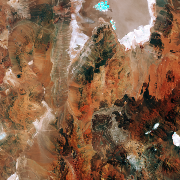
English: The Sentinel-2A satellite takes us to the diverse landscape of the eastern Atacama desert in South America. The region pictured lies around 200km east of the Chilean city of Antofagasta on the Pacific coast (not pictured), and is virtually devoid of vegetation.
At the top of the image we can see part of Chile’s largest salt flat, the Salar de Atacama. With an average elevation of some 2300 m above sea level, it is formed by waters flowing down from the Andes, which, having no drainage outlets, are forced to evaporate, leaving salt deposits. It is the world’s largest and purest active source of lithium, containing some 30% of the world's lithium reserve base, and providing almost 30% of the world’s lithium carbonate supply. The bright turquoise rectangles and squares visible along the top part of the image are evaporation ponds. Subsurface salt brines are pumped from beneath the saline crust in two different areas. In one of them, extracted salt brines have unrivalled concentration levels of potassium and lithium. In the other, the brines obtained contain high concentrations of sulphate and boron. In the lower right part of the image we can see the Socompa stratovolcano, known for its ‘debris avalanche deposit’ where the land collapsed on its western rim some 7000 years ago. The area has since been partially filled by lava, and we can see dark lava flows around the volcano. The multispectral instrument on Sentinel-2 uses parts of the infrared spectrum to analyse mineral composition where vegetation is sporadic. In this false-colour image, the intense shades of brown and orange come from the use of an infrared part of the spectrum leading to an exaggeration of colour intensity. This image – also featured on theEarth from Space video programme– was captured by Sentinel-2A on 8 March. The satellite is the first in the twin satellite Sentinel-2 mission for Europe’s Copernicus programme, and carries a wide-swath high-resolution multispectral imager with 13 spectral bands, for a new angle on our land and vegetation. |
| Date | |
| Source | http://www.esa.int/spaceinimages/Images/2016/05/Chile_s_salt_flat |
| Author | European Space Agency |
| Permission (Reusing this file) |
Contains modified Copernicus Sentinel data [2016], processed by ESA,CC BY-SA 3.0 IGO |
| Other versions |
|
| Title | Chile's salt flat |
| Location | Chile |
| Keywords | Deserts |
| Set | Earth observation image of the week |
| Mission | Sentinel-2 |
| Activity | Observing the Earth |

Licensing
[edit]This media was created by the European Space Agency (ESA).
Where expressly so stated, images or videos are covered by the Creative Commons Attribution-ShareAlike 3.0 IGO (CC BY-SA 3.0 IGO) licence, ESA being an Intergovernmental Organisation (IGO), as defined by the CC BY-SA 3.0 IGO licence. The user is allowed under the terms and conditions of the CC BY-SA 3.0 IGO license to Reproduce, Distribute and Publicly Perform the ESA images and videos released under CC BY-SA 3.0 IGO licence and the Adaptations thereof, without further explicit permission being necessary, for as long as the user complies with the conditions and restrictions set forth in the CC BY-SA 3.0 IGO licence, these including that:
See the ESA Creative Commons copyright notice for complete information, and this article for additional details.
|
 | |
This file is licensed under the Creative Commons Attribution-ShareAlike 3.0 IGO license. Attribution: ESA, CC BY-SA IGO 3.0
| ||

|
This image contains data from a satellite in the Copernicus Programme, such as Sentinel-1, Sentinel-2 or Sentinel-3. Attribution is required when using this image.
Attribution: Contains modified Copernicus Sentinel data 2016
The use of Copernicus Sentinel Data is regulated under EU law (Commission Delegated Regulation (EU) No 1159/2013 and Regulation (EU) No 377/2014). Relevant excerpts:
Free access shall be given to GMES dedicated data [...] made available through GMES dissemination platforms [...].
Access to GMES dedicated data [...] shall be given for the purpose of the following use in so far as it is lawful:
GMES dedicated data [...] may be used worldwide without limitations in time.
GMES dedicated data and GMES service information are provided to users without any express or implied warranty, including as regards quality and suitability for any purpose. |
File history
Click on a date/time to view the file as it appeared at that time.
| Date/Time | Thumbnail | Dimensions | User | Comment | |
|---|---|---|---|---|---|
| current | 13:02, 7 May 2017 |  | 5,000 × 5,000 (70.07 MB) | Fæ (talk | contribs) | == {{int:filedesc}} == {{information | description = {{en|1=The Sentinel-2A satellite takes us to the diverse landscape of the eastern Atacama desert in South America. The region pictured lies around 200km east of the Chilean city of Antofagasta on the... |
You cannot overwrite this file.
File usage on Commons
The following page uses this file: