File:Lake MacKay, Australia ESA376276.tiff

Original file (4,101 × 3,288 pixels, file size: 70.86 MB, MIME type: image/tiff)
Captions
Captions
Summary
[edit]| Description |
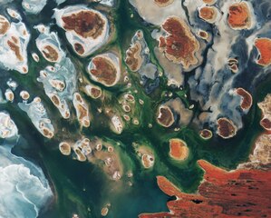
English: Lake MacKay, Australia, by Copernicus Sentinel-2B satellite.
Brown hills speckle the eastern part of Australia’s Lake MacKay in this satellite image. Located on the border of the states of Western Australia and Northern Territory, the salt lake only sees water after seasonal rainfall – if at all. It is classified as an ephemeral lake, meaning it exists only after precipitation. This is not the same as a seasonal lake, which sees water for longer periods. About half of Australia's rivers drain inland and often end in ephemeral salt lakes. The greens and blues in this image show desert vegetation or algae, soil moisture and minerals – mainly salt. On some of the brown ‘islands’ and on the shore in the lower right, we can see the east–west sand ridges forming lines in the landscape. The lake lies at the edge of the Great Sandy Desert, which covers nearly 285 000 sq km. Roads are scarce in the area, and often frequented by four-wheel drive adventurers. Roads include the Canning Stock Route about 300 km to the west of the image, or Tanami Track connecting Australia’s Stuart Highway to the Great Northern Highway around 300 km to the east. |
| Date | |
| Source | http://www.esa.int/spaceinimages/Images/2017/04/Lake_MacKay_Australia |
| Author | ESA / Copernicus Sentinel |
| Other versions |
|

Licensing
[edit]- You are free:
- to share – to copy, distribute and transmit the work
- to remix – to adapt the work
- Under the following conditions:
- attribution – You must give appropriate credit, provide a link to the license, and indicate if changes were made. You may do so in any reasonable manner, but not in any way that suggests the licensor endorses you or your use.
- share alike – If you remix, transform, or build upon the material, you must distribute your contributions under the same or compatible license as the original.
This file, which was originally posted to
http://www.esa.int/spaceinimages/Images/2017/04/Lake_MacKay_Australia, was reviewed on 6 May 2017 by reviewer Daphne Lantier, who confirmed that it was available there under the stated license on that date.
|

|
This image contains data from a satellite in the Copernicus Programme, such as Sentinel-1, Sentinel-2 or Sentinel-3. Attribution is required when using this image.
Attribution: Contains modified Copernicus Sentinel data 2017
The use of Copernicus Sentinel Data is regulated under EU law (Commission Delegated Regulation (EU) No 1159/2013 and Regulation (EU) No 377/2014). Relevant excerpts:
Free access shall be given to GMES dedicated data [...] made available through GMES dissemination platforms [...].
Access to GMES dedicated data [...] shall be given for the purpose of the following use in so far as it is lawful:
GMES dedicated data [...] may be used worldwide without limitations in time.
GMES dedicated data and GMES service information are provided to users without any express or implied warranty, including as regards quality and suitability for any purpose. |
File history
Click on a date/time to view the file as it appeared at that time.
| Date/Time | Thumbnail | Dimensions | User | Comment | |
|---|---|---|---|---|---|
| current | 10:38, 5 May 2017 |  | 4,101 × 3,288 (70.86 MB) | Yann (talk | contribs) | Transferred from http://esamultimedia.esa.int/img/2017/04/Lake_MacKay_S2B_15March2017_432_enhanced.tif |
| 10:38, 5 May 2017 |  | 4,101 × 3,288 (70.86 MB) | Yann (talk | contribs) | Transferred from http://esamultimedia.esa.int/img/2017/04/Lake_MacKay_S2B_15March2017_432_enhanced.tif |
You cannot overwrite this file.
File usage on Commons
The following 2 pages use this file:
File usage on other wikis
The following other wikis use this file:
- Usage on www.wikidata.org